
Attēls:Balti ap 13.gs.svg

Size of this PNG preview of this SVG file: 549 × 600 pikseļi. Citi izmēri: 220 × 240 pikseļi | 439 × 480 pikseļi | 703 × 768 pikseļi | 937 × 1 024 pikseļi | 1 874 × 2 048 pikseļi | 1 003 × 1 096 pikseļi.
Sākotnējais fails (SVG fails, definētais izmērs 1 003 × 1 096 pikseļi, faila izmērs: 530 KB)
| Šis fails ir no Vikikrātuves. Tā apraksts no attēla lapas Vikikrātuvē ir parādīts zemāk. Vikikrātuve ir brīvi licencēta failu krātuve. Tu vari tai palīdzēt. |
Kopsavilkums
| Apraksts |
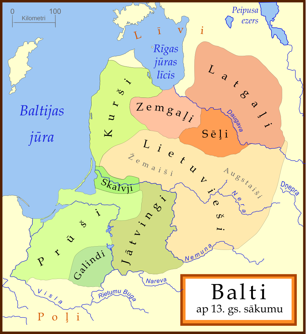
[] Català: Un mapa de les tribus bàltiques, cap al 1200 d.C. Els bàltics orientals es mostren en tons marrons mentre que els bàltics occidentals es mostren en verd. Els límits són aproximats. Aquest mapa utilitza una projecció de Mercator. Deutsch: Karte der baltischen Stämme um 1200. Ostbalten in Braun, Westbalten in Grün. Ungefähre Grenzen. English: A map of the Baltic Tribes, about 1200 AD. The Eastern Balts are shown in brown hues while the Western Balts are shown in green. The boundaries are approximate. This map uses a Mercator projection. Español: Mapa de las tribus bálticas, alrededor de 1200 d.C. Los bálticos orientales se muestran en tonos marrones, mientras que los bálticos occidentales están mostrados en verde. Las fronteras son aproximadas. Français : Une carte des peuples baltes vers 1200. Les Baltes orientaux sont représentés en marron, tandis que les Baltes occidentaux sont représentés en vert. Les frontières sont approximatives. Latviešu: Baltu cilšu apdzīvotās teritorijas aptuveni 12-13 gs. mijā. Robežas ir aptuvenas. Rietumbalti kartē iezīmēt zaļganos toņos, austrumbalti - brūnganos. Lietuvių: Baltų genčių teritorija apie 1200 metus. Vakarų baltų teritorija yra nuspalvinta žaliomis, rytų - rusvomis spalvomis. Teritorijos yra apytikslės. Magyar: A balti törzsek területei 1200 körül. A keleti-balt törzseket barnás, a nyugati-baltokat zöldes színek jelölik. Nederlands: De Baltische volkeren ca. 1200 AD. Oostbalten in bruin, Westbalten in groen. Grenzen zijn bij benadering. Polski: Mapa ukazuje plemiona Bałtyjskie, około 1200 n.e. Wschodni Bałtowie są w odcieniach brązu, zachodni - zieleni. Беларуская: Мапа балтыйскіх плямёнаў у канцы 12 — пачату 13 стагодзьдзяў. Тэрыторыі ўсходніх балтаў афарбаваныя ў карычневых адценьнях, у той жа час тэрыторыі заходніх балтаў афарбаваныя ў адценьні зялёнага колеру. Межы ўказаныя прыблізна. Русский: Карта балтийских племен в конце 12 – начале 13 веков. Территории восточных балтов окрашены в коричневых оттенках, в то время как территории западных балтов окрашены в оттенках зеленого цвета. Границы указаны приблизительно. Українська: Карта балтійських племен 1200 року. Території східних балтів фарбовані коричневими відтінтакми, а території західних балтів - зеленими. Межі народів вказані умовно. |
||
| Datums | |||
| Avots | Based on a map by en:Marija Gimbutas, published in The Balts (1963) LCC 63018018. Available at Vaidilute.com | ||
| Autors | en:user:MapMaster | ||
| Citas versijas |
[]
|
.svg&lang=ca)


.svg)

.svg)


In addition to Gimbutas, several other maps were also consulted, including:
- "Libiesi Citu Senas Latvijas Cilsu Vidu" (Livonians and other tribes of ancient Latvia 10th - 12th centuries) A map from the Latvijas Enciklopedja/ archive copy at the Wayback Machine
- Map at Emokykla.LT
- Another map at Emokykla.LT
This map uses a Mercator projection.
Other versions
Licence
Es, šī darba autortiesību īpašnieks, publicēju to saskaņā ar šo licenci:

|
Ir dota atļauja kopēt, izplatīt un/vai pārveidot šo dokumentu saskaņā ar GNU brīvās dokumentācijas licences, versijas 1.2 vai jebkuras vēlākas versijas, ko publiskojis Brīvās programmatūras fonds nosacījumiem; bez nemainīgajām sadaļā, priekšējā un aizmugurēja'vāka tekstiem. Licences kopija ir iekļauta sadaļā ar nosaukumu GNU brīvās dokumentācijas licence. |
| Šis fails tiek izplatīts saskaņā ar licences Creative Commons Atsauce-Līdzīgi Noteikumi 3.0 Vispārējiem noteikumiem. | ||
| ||
| This licensing tag was added to this file as part of the GFDL licensing update. |
Faila hronoloģija
Uzklikšķini uz datums/laiks kolonnā esošās saites, lai apskatītos, kā šis fails izskatījās tad.
| Datums/Laiks | Attēls | Izmēri | Dalībnieks | Komentārs | |
|---|---|---|---|---|---|
| tagadējais | 2008. gada 23. februāris, plkst. 19.35 | | 1 003 × 1 096 (530 KB) | Renata3 | color fixed |
| 2007. gada 22. janvāris, plkst. 06.16 |  | 1 003 × 1 096 (530 KB) | MapMaster | fixed one error | |
| 2007. gada 20. janvāris, plkst. 02.58 |  | 1 003 × 1 096 (515 KB) | MapMaster | Balti ap 13.gs. sākumu (Baltic tribes ca. 1200 AD) |
Faila lietojums
Šo failu izmanto šajās 18 lapās:
Globālais faila lietojums
Šīs Vikipēdijas izmanto šo failu:
- Izmantojums hr.wikipedia.org
- Izmantojums sh.wikipedia.org
- Izmantojums sk.wikipedia.org