
Attēls:Bronx Highlight New York City Map Julius Schorzman.png
Šī priekšskata izmērs: 616 × 600 pikseļi. Citi izmēri: 247 × 240 pikseļi | 493 × 480 pikseļi | 789 × 768 pikseļi | 1 052 × 1 024 pikseļi | 2 104 × 2 048 pikseļi | 2 652 × 2 582 pikseļi.
Sākotnējais fails (2 652 × 2 582 pikseļi, faila izmērs: 4,67 MB, MIME tips: image/png)
| Šis fails ir no Vikikrātuves. Tā apraksts no attēla lapas Vikikrātuvē ir parādīts zemāk. Vikikrātuve ir brīvi licencēta failu krātuve. Tu vari tai palīdzēt. |
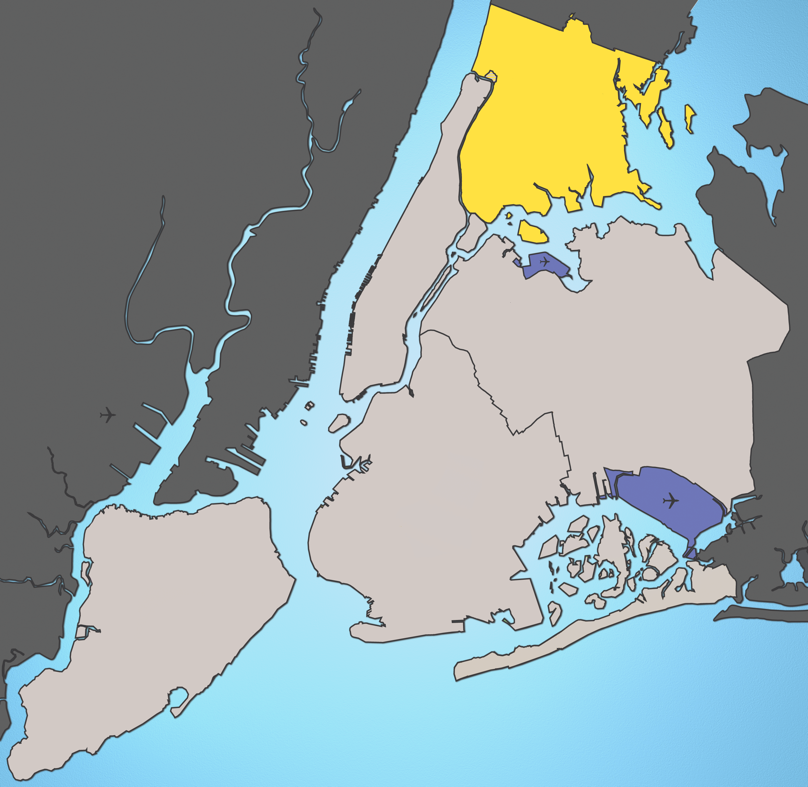
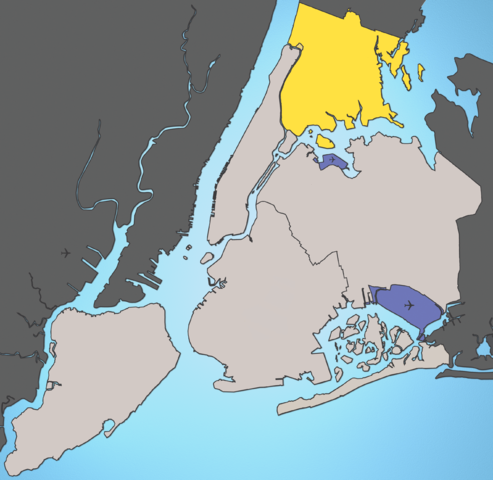
A map of New York City with the Bronx highlighted.

|
This map image could be re-created using vector graphics as an SVG file. This has several advantages; see Commons:Media for cleanup for more information. If an SVG form of this image is available, please upload it and afterwards replace this template with
{{vector version available|new image name}}.
It is recommended to name the SVG file “Bronx Highlight New York City Map Julius Schorzman.svg”—then the template Vector version available (or Vva) does not need the new image name parameter. |
Notes:
- Marble Hill is shown as part Manhattan, part Bronx. See Wikipedia:Marble Hill, Manhattan, New York for more information.
- Several islands (such as Rikers Island) are highlighted since they are governmentally a part of the Bronx
Source: I created this image using various maps and images.
Attribution: Julius Schorzman
Šis fails tiek izplatīts saskaņā ar licences Creative Commons Atsauce-Līdzīgi Noteikumi 2.5 Vispārējiem noteikumiem.
- Jūs varat brīvi:
- koplietot – kopēt, izplatīt un pārraidīt darbu
- remiksēt – pielāgot darbu
- Saskaņā ar šādiem nosacījumiem:
- atsaucoties – Tev ir jānorāda autors, saite uz licenci un to, vai veiktas kādas izmaiņas. To var darīt jebkādā saprātīgā veidā, bet ne tādā, kas norādītu, ka licencētājs atbalsta tevi vai veidu, kā tu izmanto šo darbu.
- nemainot licenci – Ja tu miksē, pārveido vai izmanto materiālu, tev savs devums jāpublicē ar to pašu vai saderīgu licenci kā oriģināls.
\
Faila hronoloģija
Uzklikšķini uz datums/laiks kolonnā esošās saites, lai apskatītos, kā šis fails izskatījās tad.
| Datums/Laiks | Attēls | Izmēri | Dalībnieks | Komentārs | |
|---|---|---|---|---|---|
| tagadējais | 2005. gada 19. augusts, plkst. 05.01 | | 2 652 × 2 582 (4,67 MB) | Quasipalm | A map of New York City with the Bronx highlighted. Notes: # '''Marble Hill''' is shown as part Manhattan, part Bronx. See wiki:Marble Hill for more information. # Several islands (such as '''Rikers Island''') are highlighted since they are governmen |
Faila lietojums
Šo failu izmanto šajā 1 lapā:
Globālais faila lietojums
Šīs Vikipēdijas izmanto šo failu:
- Izmantojums bg.wikipedia.org
- Izmantojums bs.wikipedia.org
- Izmantojums de.wikipedia.org
- Izmantojums en.wikipedia.org
- Izmantojums en.wikinews.org
- Izmantojums fa.wikipedia.org
- Izmantojums frr.wikipedia.org
- Izmantojums fr.wikipedia.org
- Izmantojums fr.wikinews.org
- Izmantojums fr.wiktionary.org
- Izmantojums fy.wikipedia.org
- Izmantojums he.wikipedia.org
- Izmantojums hr.wikipedia.org
- Izmantojums hu.wikipedia.org
- Izmantojums is.wikipedia.org
- Izmantojums ja.wikipedia.org
- Izmantojums ka.wikipedia.org
- Izmantojums ko.wikipedia.org
- Izmantojums lt.wikipedia.org
- Izmantojums mk.wikipedia.org
- Izmantojums mr.wikipedia.org
- Izmantojums pl.wikipedia.org
- Izmantojums pt.wikipedia.org
- Izmantojums ru.wikipedia.org
- Izmantojums sh.wikipedia.org
- Izmantojums sk.wikipedia.org
- Izmantojums sr.wikipedia.org
- Izmantojums sw.wikipedia.org
- Izmantojums th.wikipedia.org
- Izmantojums tl.wikipedia.org
- Izmantojums uk.wikipedia.org
- Izmantojums xmf.wikipedia.org
- Izmantojums zh-min-nan.wikipedia.org