
Attēls:Closeup aerial view of Downtown Oakland and Lakeside Park.jpg

Šī priekšskata izmērs: 800 × 600 pikseļi. Citi izmēri: 320 × 240 pikseļi | 640 × 480 pikseļi | 1 024 × 768 pikseļi | 1 280 × 960 pikseļi | 2 560 × 1 920 pikseļi | 3 264 × 2 448 pikseļi.
Sākotnējais fails (3 264 × 2 448 pikseļi, faila izmērs: 5,55 MB, MIME tips: image/jpeg)
| Šis fails ir no Vikikrātuves. Tā apraksts no attēla lapas Vikikrātuvē ir parādīts zemāk. Vikikrātuve ir brīvi licencēta failu krātuve. Tu vari tai palīdzēt. |
Kopsavilkums
| Apraksts |
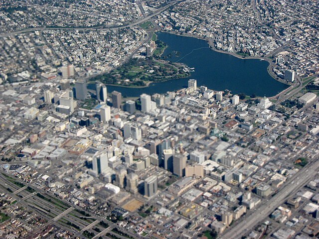
English: Closeup aerial view of Downtown Oakland, Lake Merritt, and Lakeside Park in Oakland, California. |
| Datums | |
| Avots | Paša darbs |
| Autors | Dcoetzee |
| Camera location | | View this and other nearby images on: OpenStreetMap |
|---|
Licence
| I, the copyright holder of this work, release this work into the public domain. This applies worldwide. In some countries this may not be legally possible; if so: I grant anyone the right to use this work for any purpose, without any conditions, unless such conditions are required by law. |
Faila hronoloģija
Uzklikšķini uz datums/laiks kolonnā esošās saites, lai apskatītos, kā šis fails izskatījās tad.
| Datums/Laiks | Attēls | Izmēri | Dalībnieks | Komentārs | |
|---|---|---|---|---|---|
| tagadējais | 2009. gada 4. jūnijs, plkst. 10.04 | | 3 264 × 2 448 (5,55 MB) | Dcoetzee | {{Information |Description={{en|1=Closeup aerial view of Downtown Oakland, Lake Merritt, and Lakeside Park in Oakland, California.}} |Source=Own work by uploader |Author=Dcoetzee |Date=See metadata |Permission= |other_versions= }} {{loca |
Faila lietojums
Šo failu izmanto šajā 1 lapā:
Globālais faila lietojums
Šīs Vikipēdijas izmanto šo failu:
- Izmantojums ar.wikipedia.org
- Izmantojums br.wikipedia.org
- Izmantojums ceb.wikipedia.org
- Izmantojums de.wikivoyage.org
- Izmantojums en.wikipedia.org
- Izmantojums en.wikivoyage.org
- Izmantojums es.wikipedia.org
- Izmantojums fr.wikipedia.org
- Izmantojums hy.wikipedia.org
- Izmantojums it.wikipedia.org
- Izmantojums it.wikivoyage.org
- Izmantojums ja.wikipedia.org
- Izmantojums kw.wikipedia.org
- Izmantojums ms.wikipedia.org
- Izmantojums nn.wikipedia.org
- Izmantojums pt.wikipedia.org
- Izmantojums ro.wikipedia.org
- Izmantojums tr.wikipedia.org
- Izmantojums war.wikipedia.org
- Izmantojums www.wikidata.org
- Izmantojums zh-yue.wikipedia.org
- Izmantojums zh.wikipedia.org