
Attēls:Easter Island map-en.svg

Size of this PNG preview of this SVG file: 800 × 569 pikseļi. Citi izmēri: 320 × 228 pikseļi | 640 × 455 pikseļi | 1 024 × 729 pikseļi | 1 280 × 911 pikseļi | 2 560 × 1 821 pikseļi | 1 750 × 1 245 pikseļi.
Sākotnējais fails (SVG fails, definētais izmērs 1 750 × 1 245 pikseļi, faila izmērs: 878 KB)
| Šis fails ir no Vikikrātuves. Tā apraksts no attēla lapas Vikikrātuvē ir parādīts zemāk. Vikikrātuve ir brīvi licencēta failu krātuve. Tu vari tai palīdzēt. |
Kopsavilkums
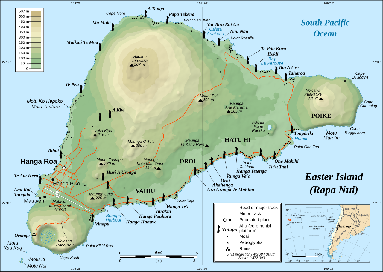
This image was selected as picture of the day on Wikimedia Commons for 1 December 2008. It was captioned as follows: English: Detailed topographic map in English of Easter Island. Other languages:
Afrikaans: Gedetaileerde topografie van Paaseiland Català: Mapa topogràfic detallat en anglès de l'Illa de Pasqua. Čeština: Detailní topografická mapa Velikonočního ostrova Eesti: Detailne inglisekeelne topograafiline kaart et:Lihavõttesaarest. English: Detailed topographic map in English of Easter Island. Esperanto: detala topografia mapo de la Paskinsulo (jen anglalingva, sed ankaŭ havebla en pluraj aliaj lingvoj) Français : Carte topographique détaillée en anglais de l'île de Pâques Italiano: Mappa topografica dell'Isola di Pasqua, Cile. Nederlands: Engelstalige gedetailleerde topografische kaart van Paaseiland Português: Mapa topográfico detalhado, em Inglês, da Ilha da Páscoa Română: Hartă topografică detaliată, în limba engleză, a insulei Paștelui. Svenska: Detaljerad topografisk karta på engelska över Påskön. Македонски: Детална топографска карта на Велигденскиот Остров на англиски. Русский: Топографическая карта Острова Пасхи 한국어: 이스터 섬의 지형도. 中文: 复活节岛地形图 中文(繁體): 復活節島地形圖 |
|

| Apraksts |
English: Detailed topographic map in English of Easter Island
Français : Carte topographique détaillée en anglais de l'île de Paques
Português: Mapa topográfico detalhado, em Inglês, da Ilha da Páscoa.
|
| Datums | October 2007 - October 2008 for the new version (see the release note) |
| Avots |
Own work
|
| Autors | Eric Gaba (Sting), translated by Bamse |
| Atļauja: (Šī faila izmantošana citur) |
Creative Commons: Share Alike – attribution required |
| Citas versijas |
[]
|


![[1]](http://www.waymarker.co.uk/ml/rapanui/map.jpg)
This W3C-unspecified vector image was created with Inkscape .

|
This SVG file contains embedded text that can be translated into your language, using any capable SVG editor, text editor or the SVG Translate tool. For more information see: About translating SVG files. |
Licence
Es, šī darba autortiesību īpašnieks, publicēju to saskaņā ar šo licenci:
Šis fails tiek izplatīts saskaņā ar licences Creative Commons Atsauce-Līdzīgi Noteikumi 2.5 Vispārējiem noteikumiem.
- Jūs varat brīvi:
- koplietot – kopēt, izplatīt un pārraidīt darbu
- remiksēt – pielāgot darbu
- Saskaņā ar šādiem nosacījumiem:
- atsaucoties – Tev ir jānorāda autors, saite uz licenci un to, vai veiktas kādas izmaiņas. To var darīt jebkādā saprātīgā veidā, bet ne tādā, kas norādītu, ka licencētājs atbalsta tevi vai veidu, kā tu izmanto šo darbu.
- nemainot licenci – Ja tu miksē, pārveido vai izmanto materiālu, tev savs devums jāpublicē ar to pašu vai saderīgu licenci kā oriģināls.
Faila hronoloģija
Uzklikšķini uz datums/laiks kolonnā esošās saites, lai apskatītos, kā šis fails izskatījās tad.
| Datums/Laiks | Attēls | Izmēri | Dalībnieks | Komentārs | |
|---|---|---|---|---|---|
| tagadējais | 2023. gada 12. janvāris, plkst. 01.51 | | 1 750 × 1 245 (878 KB) | Tseng,Lu-Yen | Reverted to version as of 12:43, 22 October 2008 (UTC) |
| 2011. gada 10. decembris, plkst. 10.17 |  | 1 750 × 1 245 (1,92 MB) | Hel-hama | Text appearance improved using Inkscape. | |
| 2008. gada 22. oktobris, plkst. 15.43 |  | 1 750 × 1 245 (878 KB) | Sting | Completely new version of the map ; new standard colors | |
| 2007. gada 30. oktobris, plkst. 04.06 |  | 1 750 × 1 245 (536 KB) | Sting | Some additional info | |
| 2007. gada 19. oktobris, plkst. 03.37 |  | 1 750 × 1 245 (534 KB) | Bamse | ||
| 2007. gada 19. oktobris, plkst. 03.14 |  | 1 750 × 1 245 (534 KB) | Bamse | {{Information |Description= |Source=self-made |Date= |Author= Bamse }} == Summary == {{Information| |Description=Detailed topographic map in English of Easter island |Source=Own work, translation of Image:Easter Island map-fr.svg<b |
Faila lietojums
Šo failu izmanto šajā 1 lapā:
Globālais faila lietojums
Šīs Vikipēdijas izmanto šo failu:
- Izmantojums af.wikipedia.org
- Izmantojums ami.wikipedia.org
- Izmantojums ar.wikipedia.org
- Izmantojums az.wikipedia.org
- Izmantojums bcl.wikipedia.org
- Izmantojums bn.wikipedia.org
- Izmantojums ca.wikipedia.org
- Izmantojums ckb.wikipedia.org
- Izmantojums da.wikipedia.org
- Izmantojums de.wikipedia.org
- Izmantojums el.wikipedia.org
- Izmantojums en.wikipedia.org
- Cartography
- Easter Island
- Hanga Roa
- Mu (mythical lost continent)
- Moai
- Motu Nui
- Map coloring
- Rapa Nui National Park
- Hanau epe
- Orongo
- Ahu Tongariki
- Poike
- Rano Kau
- Terevaka
- Ahu Akivi
- List of active separatist movements in Oceania
- User:ISaveNewspapers/sandbox
- Isla de Pascua (commune)
- Portal:Geodesy
- User:Iamojo/testcase/EasterIsland
- Izmantojums en.wikiversity.org
- Izmantojums en.wikivoyage.org
- Izmantojums es.wikipedia.org
- Izmantojums et.wikipedia.org
- Izmantojums fa.wikipedia.org
- Izmantojums frr.wikipedia.org
- Izmantojums fr.wikipedia.org
- Izmantojums gl.wikipedia.org
Skatīt šī faila pilno globālo izmantojumu.