Attēls:First century Iudaea province.gif
Lapas saturs netiek atbalstīts citās valodās.
Vikipēdijas lapa

Sākotnējais fails(575 × 792 pikseļi, faila izmērs: 31 KB, MIME tips: image/gif)

This map image could be re-created using vector graphics as an SVG file. This has several advantages; see Commons:Media for cleanup for more information. If an SVG form of this image is available, please upload it and afterwards replace this template with {{vector version available|new image name}}.


It is recommended to name the SVG file “First century Iudaea province.svg”—then the template Vector version available (or Vva) does not need the new image name parameter.

Kopsavilkums

Apraksts
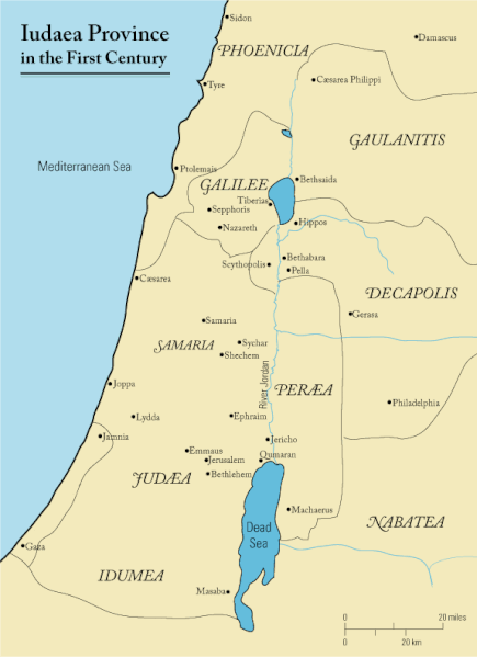
English: This is a map of first century Iudaea Province that I created using Illustrator CS2. I traced this image for the general geographic features. I then manually input data from maps found in a couple of sources.
  • Robert W. Funk and the Jesus Seminar. The Acts of Jesus. HarperSanFrancisco: 1998. p. xxiv.
  • Michael Grant. Jesus: An Historian's Review of the Gospels. Charles Scribner's Sons: 1977. p. 65-67.
  • John P. Meier. A Marginal Jew. Doubleday: 1991. p. 1:434.
Datums 2006. gada 23. marts (original upload date)
Avots Transferred from en.wikipedia to Commons.
Autors Andrew c at angļu Vikipēdija
Atļauja:
(Šī faila izmantošana citur)
Released under the GNU Free Documentation License or CC-BY.
Citas versijas العربيَّة

Licence

Andrew c from en.wikipedia.org, šī darba autortiesību īpašnieks, publicē to saskaņā ar šo licenci:
GNU head Ir dota atļauja kopēt, izplatīt un/vai pārveidot šo dokumentu saskaņā ar GNU brīvās dokumentācijas licences, versijas 1.2 vai jebkuras vēlākas versijas, ko publiskojis Brīvās programmatūras fonds nosacījumiem; bez nemainīgajām sadaļā, priekšējā un aizmugurēja'vāka tekstiem. Licences kopija ir iekļauta sadaļā ar nosaukumu GNU brīvās dokumentācijas licence. Subject to disclaimers.
w:en:Creative Commons
atsaucoties
Šis fails tiek izplatīts saskaņā ar licences Creative Commons Atsauce 3.0 Vispārējiem noteikumiem.
Atsauce: Wikipedia User:Andrew c
Jūs varat brīvi:
  • koplietot – kopēt, izplatīt un pārraidīt darbu
  • remiksēt – pielāgot darbu
Saskaņā ar šādiem nosacījumiem:
  • atsaucoties – Tev ir jānorāda autors, saite uz licenci un to, vai veiktas kādas izmaiņas. To var darīt jebkādā saprātīgā veidā, bet ne tādā, kas norādītu, ka licencētājs atbalsta tevi vai veidu, kā tu izmanto šo darbu.
Public domain I, the copyright holder of this work, release this work into the public domain. This applies worldwide.
In some countries this may not be legally possible; if so:
I grant anyone the right to use this work for any purpose, without any conditions, unless such conditions are required by law.

Original upload log

The original description page was here. All following user names refer to en.wikipedia.
  • 2006-03-24 18:48 Andrew c 575×792×8 (32374 bytes) This is a map of First Century Palestine that I created using Illustrator CS2. I traced [http://commons.wikimedia.org/wiki/Image:Map_of_administrative_regions_in_Israel.png this] image for the general geographic features. I then manually input data from m
  • 2006-03-23 19:48 Andrew c 587×790×8 (30752 bytes) This is a map of First Century Palestine that I created using Illustrator CS2. I traced [http://commons.wikimedia.org/wiki/Image:Map_of_administrative_regions_in_Israel.png this] image for the general geographic features. I then manually input data from m

Captions

Pievieno vienas rindiņas aprakstu, ko šis fails attēlo
Judaea province in the 1st Century CE

Šajā failā attēlotais

attēlo

23 marts 2006

image/gif

checksum angļu

e488e0183049d2138c916ccc7a24c107807f12b7

data size angļu

32 019 Baits

792 pikselis

575 pikselis

Faila hronoloģija

Uzklikšķini uz datums/laiks kolonnā esošās saites, lai apskatītos, kā šis fails izskatījās tad.

Datums/LaiksAttēlsIzmēriDalībnieksKomentārs
tagadējais2011. gada 18. septembris, plkst. 14.472011. gada 18. septembris, plkst. 14.47 versijas sīktēls575 × 792 (31 KB)OnceinawhileRemoved region-name "Philistia", as incorrect
2007. gada 13. septembris, plkst. 17.052007. gada 13. septembris, plkst. 17.05 versijas sīktēls575 × 792 (32 KB)Liftarn{{SVG|map}} {{Information |Description=This is a map of first century en:Iudaea Province that I created using Illustrator CS2. I traced [http://commons.wikimedia.org/wiki/Image:Map_of_administrative_regions_in_Israel.png this] image for the general g
2006. gada 30. aprīlis, plkst. 03.292006. gada 30. aprīlis, plkst. 03.29 versijas sīktēls575 × 792 (32 KB)Duende~commonswikihttp://en.wikipedia.org/wiki/Image:First_century_palestine.gif

Šo failu izmanto šajās 3 lapās:

Globālais faila lietojums

Šīs Vikipēdijas izmanto šo failu:

Skatīt šī faila pilno globālo izmantojumu.