
Attēls:Fusha e Tiranës 2008.jpg

Šī priekšskata izmērs: 800 × 576 pikseļi. Citi izmēri: 320 × 230 pikseļi | 640 × 461 pikseļi | 1 024 × 737 pikseļi | 1 280 × 922 pikseļi | 2 500 × 1 800 pikseļi.
Sākotnējais fails (2 500 × 1 800 pikseļi, faila izmērs: 1,78 MB, MIME tips: image/jpeg)
| Šis fails ir no Vikikrātuves. Tā apraksts no attēla lapas Vikikrātuvē ir parādīts zemāk. Vikikrātuve ir brīvi licencēta failu krātuve. Tu vari tai palīdzēt. |
Kopsavilkums
| Apraksts |
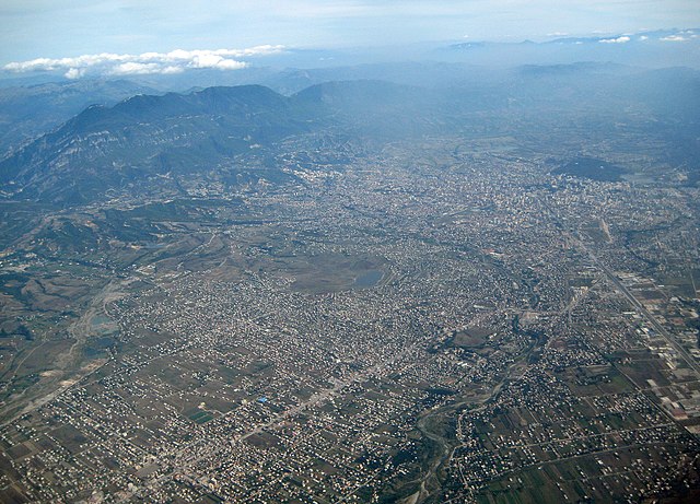
English: The Southern part of the Plain of Tirana (Albania). The mount Dajti at its Eastern end is in the upper left corner of the image. Tirana's high rise buildings and parks can be seen in the upper right corner. The motorway from Durrës in the West leading directly in Tirana's center is on the right hand side. From the lower left corner, the street from North Albania is heading to Tirana through the town of Kamza. Along this street, many new illegal settlements can be seen in the center of the picture. Between Kamza and Tirana, Tirana river makes its way to the Ocean (bottom center), as on the far left the River Zeza is to be recognized.
Deutsch: Der südliche Teil der Ebene von Tirana (Albanien) mit dem Berg Dajti links oben (Osten), den Hochhäusern und Grünflächen von Tirana rechts oben (Süden), der von Durrës im Westen herführenden Autobahn rechts, die als Hauptachse bis ins Stadtzentrum weitergeführt wird, dem Fluss Tirana unten, dem Fluss Zeza ganz links und der Strasse nach Norden unten links, entlang der rund um das Städtchen Kamza gewaltige Siedlungsflächen illegal überbaut wurden (Bildmitte) |
| Datums | |
| Avots | Paša darbs |
| Autors | Albinfo |
Licence
Es, šī darba autortiesību īpašnieks, publicēju to saskaņā ar šo licenci:
Šis fails tiek izplatīts saskaņā ar licences Creative Commons Atsauce-Līdzīgi Noteikumi 3.0 Vispārējiem noteikumiem.
- Jūs varat brīvi:
- koplietot – kopēt, izplatīt un pārraidīt darbu
- remiksēt – pielāgot darbu
- Saskaņā ar šādiem nosacījumiem:
- atsaucoties – Tev ir jānorāda autors, saite uz licenci un to, vai veiktas kādas izmaiņas. To var darīt jebkādā saprātīgā veidā, bet ne tādā, kas norādītu, ka licencētājs atbalsta tevi vai veidu, kā tu izmanto šo darbu.
- nemainot licenci – Ja tu miksē, pārveido vai izmanto materiālu, tev savs devums jāpublicē ar to pašu vai saderīgu licenci kā oriģināls.
| Annotations | This image is annotated: View the annotations at Commons |
Faila hronoloģija
Uzklikšķini uz datums/laiks kolonnā esošās saites, lai apskatītos, kā šis fails izskatījās tad.
| Datums/Laiks | Attēls | Izmēri | Dalībnieks | Komentārs | |
|---|---|---|---|---|---|
| tagadējais | 2008. gada 12. novembris, plkst. 14.38 | | 2 500 × 1 800 (1,78 MB) | Albinfo | {{Information |Description={{en|1=The Southern part of the Plain of Tirana (Albania). The mount Dajti at its Eastern end is in the upper left corner of the image. Tirana's high rise buildings and parks can be seen in the upper right corner. The motorway f |
Faila lietojums
Šo failu izmanto šajā 1 lapā:
Globālais faila lietojums
Šīs Vikipēdijas izmanto šo failu:
- Izmantojums ba.wikipedia.org
- Izmantojums be.wikipedia.org
- Izmantojums bg.wikipedia.org
- Izmantojums de.wikipedia.org
- Izmantojums en.wikipedia.org
- Izmantojums fa.wikipedia.org
- Izmantojums mdf.wikipedia.org
- Izmantojums mk.wikipedia.org
- Izmantojums mn.wikipedia.org
- Izmantojums rm.wikipedia.org
- Izmantojums ru.wikipedia.org
- Izmantojums sco.wikipedia.org
- Izmantojums sl.wikipedia.org
- Izmantojums sq.wikipedia.org
- Izmantojums sv.wikipedia.org
- Izmantojums zh.wikipedia.org