
Attēls:International E Road Network green.png

Šī priekšskata izmērs: 800 × 571 pikseļi. Citi izmēri: 320 × 229 pikseļi | 640 × 457 pikseļi.
Sākotnējais fails (840 × 600 pikseļi, faila izmērs: 38 KB, MIME tips: image/png)
| Šis fails ir no Vikikrātuves. Tā apraksts no attēla lapas Vikikrātuvē ir parādīts zemāk. Vikikrātuve ir brīvi licencēta failu krātuve. Tu vari tai palīdzēt. |

|
This road map image could be re-created using vector graphics as an SVG file. This has several advantages; see Commons:Media for cleanup for more information. If an SVG form of this image is available, please upload it and afterwards replace this template with
{{vector version available|new image name}}.
It is recommended to name the SVG file “International E Road Network green.svg”—then the template Vector version available (or Vva) does not need the new image name parameter. |
Kopsavilkums
| Apraksts |
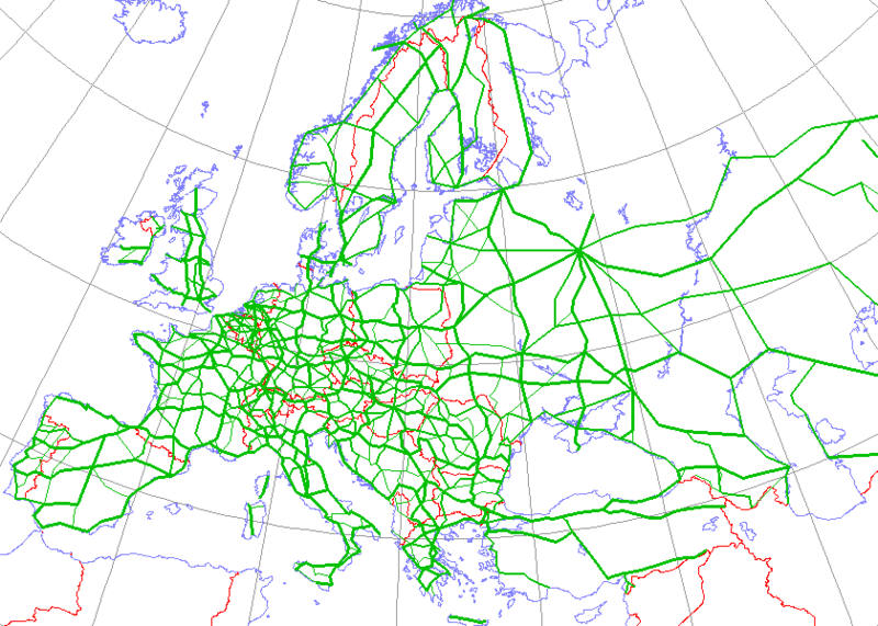
English: Map generated using coastline/boundary data from World Data Bank, and locations from http://www.world-gazetteer.com/. Straight lines connect control cities, no attempt to follow the real road. Roads color has been changed to green.
Deutsch: Diese Karte wurde mit den Küsten- und Grenzverlaufsdaten aus der World Data Bank und mit den Koordinaten aus http://www.world-gazetteer.com/ erstellt. Die Städte sind durch gerade Linien vebunden die nicht unbedingt den realen Straßenverlauf wiedergeben. Die Farbe der Straßen wurde in grün geändert.
Türkçe: Harita oluşturulken sahilyolu ve sınırlar bilgisi Dünya Bilgi Bankası'ndan ve lokasyonlar http://www.world-gazetteer.com/ adlı siteden alınmıştır. Düz çizgiler kontrol şehirlerini bağlar. Yol rengi yeşile değiştirildi. |
| Avots | http://en.wikipedia.org/wiki/Image:International_E_Road_Network.png |
| Autors | Kjhskj75 |
Licence
| I, the copyright holder of this work, release this work into the public domain. This applies worldwide. In some countries this may not be legally possible; if so: I grant anyone the right to use this work for any purpose, without any conditions, unless such conditions are required by law. |
Faila hronoloģija
Uzklikšķini uz datums/laiks kolonnā esošās saites, lai apskatītos, kā šis fails izskatījās tad.
| Datums/Laiks | Attēls | Izmēri | Dalībnieks | Komentārs | |
|---|---|---|---|---|---|
| tagadējais | 2008. gada 13. maijs, plkst. 19.09 | | 840 × 600 (38 KB) | Jklamo | Albania update |
| 2007. gada 22. decembris, plkst. 15.07 |  | 840 × 600 (39 KB) | BIL | == Description == {{Information |Description=Map generated using coastline/boundary data from World Data Bank, and locations from www.world-gazetteer.com. Straight lines connect control cities, no attempt to follow the real road. Roads color has been chan | |
| 2007. gada 7. oktobris, plkst. 23.03 |  | 840 × 600 (33 KB) | The RedBurn | All e-roads in green. | |
| 2007. gada 7. oktobris, plkst. 22.55 |  | 840 × 600 (34 KB) | The RedBurn | {{Information |Description=Map generated using coastline/boundary data from World Data Bank, and locations from www.world-gazetteer.com. Straight lines connect control cities, no attempt to follow the real road. Roads color has been changed to green. |Sou |
Faila lietojums
Šo failu izmanto šajās 45 lapās:
- Eiropas autoceļš E01
- Eiropas autoceļš E03
- Eiropas autoceļš E04
- Eiropas autoceļš E05
- Eiropas autoceļš E06
- Eiropas autoceļš E07
- Eiropas autoceļš E08
- Eiropas autoceļš E09
- Eiropas autoceļš E10
- Eiropas autoceļš E11
- Eiropas autoceļš E12
- Eiropas autoceļš E13
- Eiropas autoceļš E14
- Eiropas autoceļš E15
- Eiropas autoceļš E16
- Eiropas autoceļš E17
- Eiropas autoceļš E18
- Eiropas autoceļš E19
- Eiropas autoceļš E20
- Eiropas autoceļš E21
- Eiropas autoceļš E22
- Eiropas autoceļš E23
- Eiropas autoceļš E25
- Eiropas autoceļš E261
- Eiropas autoceļš E262
- Eiropas autoceļš E263
- Eiropas autoceļš E264
- Eiropas autoceļš E265
- Eiropas autoceļš E271
- Eiropas autoceļš E272
- Eiropas autoceļš E28
- Eiropas autoceļš E30
- Eiropas autoceļš E36
- Eiropas autoceļš E371
- Eiropas autoceļš E372
- Eiropas autoceļš E40
- Eiropas autoceļš E462
- Eiropas autoceļš E65
- Eiropas autoceļš E67
- Eiropas autoceļš E75
- Eiropas autoceļš E77
- Eiropas autoceļš E85
- Eiropas autoceļš E95
- Starptautiskais E ceļu tīkls
- Veidne:Eiropas nozīmes autoceļi
Globālais faila lietojums
Šīs Vikipēdijas izmanto šo failu:
- Izmantojums ar.wikipedia.org
- Izmantojums be.wikipedia.org
- Izmantojums bg.wikipedia.org
- Европейски път
- Европейски път Е79
- Европейски път Е70
- Европейски път Е80
- Европейски път Е67
- Европейски път Е85
- Европейски път Е851
- Европейски път Е671
- Шаблон:Европейска пътна мрежа
- Европейски път Е81
- Европейски път Е804
- Европейски път Е763
- Европейски път Е762
- Европейски път Е87
- Европейски път Е772
- Европейски път Е83
- Европейски път Е871
- Европейски път Е75
- Европейски път Е773
- Европейски път Е11
- Европейски път Е51
- Европейски път Е761
- Европейски път Е17
- Европейски път Е76
- Европейски път Е82
- Европейски път Е84
- Европейски път Е86
- Европейски път E01
- Европейски път E03
- Европейски път E04
- Европейски път E05
- Европейски път E06
- Европейски път E07
- Европейски път E08
- Европейски път E09
- Европейски път E10
- Европейски път E12
- Европейски път E13
- Европейски път E14
Skatīt šī faila pilno globālo izmantojumu.