
Attēls:Iron Curtain map.svg

Size of this PNG preview of this SVG file: 560 × 599 pikseļi. Citi izmēri: 224 × 240 pikseļi | 449 × 480 pikseļi | 718 × 768 pikseļi | 957 × 1 024 pikseļi | 1 914 × 2 048 pikseļi | 645 × 690 pikseļi.
Sākotnējais fails (SVG fails, definētais izmērs 645 × 690 pikseļi, faila izmērs: 322 KB)
| Šis fails ir no Vikikrātuves. Tā apraksts no attēla lapas Vikikrātuvē ir parādīts zemāk. Vikikrātuve ir brīvi licencēta failu krātuve. Tu vari tai palīdzēt. |
Kopsavilkums
| Apraksts |
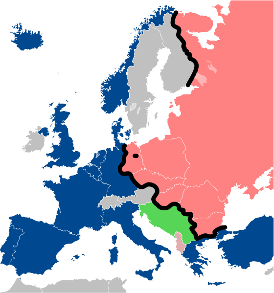
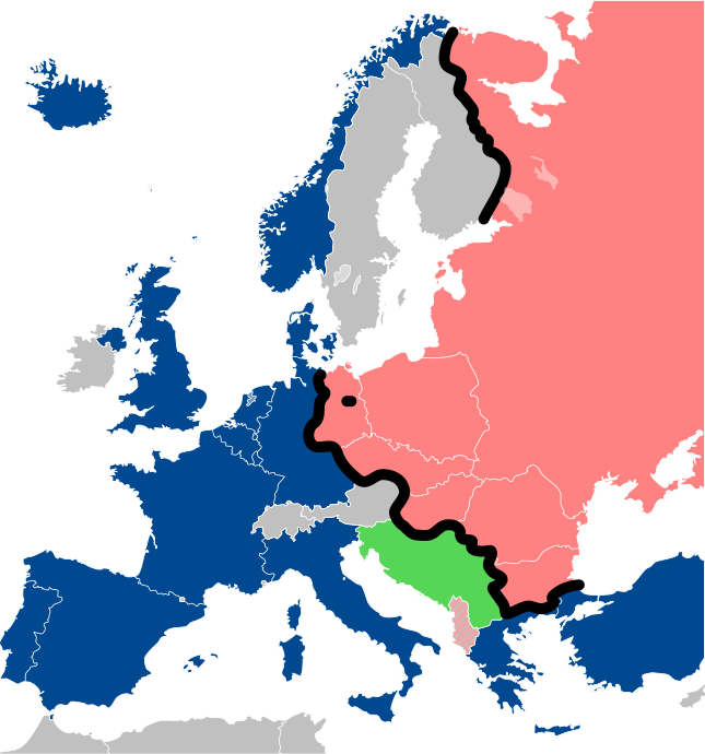
Lëtzebuergesch: Kaart vum Westen an dem Ostblock an Europa während dem Kale Krich.
"Eise Rido"
Neutral Länner
|
||
| Datums | |||
| Avots |
Travail personnel (own work). Sources:
|
||
| Autors | Sémhur | ||
| Citas versijas |
File:Iron Curtain map alternative.svg (Same, but with Yugoslavia on the Eastern side of the Iron Curtain.) | ||
| Atsauce (required by the license) | © Sémhur / Wikimedia Commons / | ||
| SVG | W3C-validity not checked.
|
||
| Graphic Lab |

| Camera location | | View this and other nearby images on: OpenStreetMap |
|---|
Licence
Es, šī darba autortiesību īpašnieks, publicēju to saskaņā ar šīm licencēm:
| Copyleft: This work of art is free; you can redistribute it and/or modify it according to terms of the Free Art License. You will find a specimen of this license on the Copyleft Attitude site as well as on other sites. |
This file is licensed under the Creative Commons Attribution-Share Alike 4.0 International, 3.0 Unported, 2.5 Generic, 2.0 Generic and 1.0 Generic license.
- Jūs varat brīvi:
- koplietot – kopēt, izplatīt un pārraidīt darbu
- remiksēt – pielāgot darbu
- Saskaņā ar šādiem nosacījumiem:
- atsaucoties – Tev ir jānorāda autors, saite uz licenci un to, vai veiktas kādas izmaiņas. To var darīt jebkādā saprātīgā veidā, bet ne tādā, kas norādītu, ka licencētājs atbalsta tevi vai veidu, kā tu izmanto šo darbu.
- nemainot licenci – Ja tu miksē, pārveido vai izmanto materiālu, tev savs devums jāpublicē ar to pašu vai saderīgu licenci kā oriģināls.
Jūs varat izvēlēties licenci pēc jūsu vēlmes.
Faila hronoloģija
Uzklikšķini uz datums/laiks kolonnā esošās saites, lai apskatītos, kā šis fails izskatījās tad.
| Datums/Laiks | Attēls | Izmēri | Dalībnieks | Komentārs | |
|---|---|---|---|---|---|
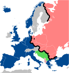
| tagadējais | 2022. gada 15. decembris, plkst. 16.26 | | 645 × 690 (322 KB) | PhotographyEdits | Extend the Iron Curtain eastwards of Yugoslavia. Even though Yugoslavia was not really considered part of the West, the currenet map gives the false impression that there was a huge gap in the Iron Curtain, which wasn't the case. |
| 2022. gada 23. jūlijs, plkst. 03.56 |  | 645 × 690 (321 KB) | Kwamikagami | NATO blue, #004990 | |
| 2019. gada 30. marts, plkst. 23.30 |  | 645 × 690 (321 KB) | Sémhur | Reverted to version as of 07:07, 27 May 2014 (UTC). Albania leaves the Waras Pack in middle of cold war; this is why it's shown wtih stripes. | |
| 2019. gada 24. marts, plkst. 12.18 |  | 512 × 548 (123 KB) | Hakuli | Albania leaves the Waras Pack in middle of cold war | |
| 2014. gada 27. maijs, plkst. 10.07 |  | 645 × 690 (321 KB) | Sémhur | Valid SVG | |
| 2010. gada 16. novembris, plkst. 16.51 |  | 645 × 690 (321 KB) | Sémhur | Added Iron Curtain between Bulgaria and Greece & Turkey. | |
| 2008. gada 27. septembris, plkst. 19.57 |  | 645 × 690 (321 KB) | Sémhur | Correcting mistake : Austria wasn't in NATO. | |
| 2008. gada 31. maijs, plkst. 13.51 |  | 645 × 690 (330 KB) | Sémhur | {{Information |Description={{en|1=Map of the Iron Curtain in Europe.}} {{fr|1=Carte du rideau de fer en Europe.}} {{es|1=Mapa del Telón de Acero en Europa.}} |Source=Travail personnel (ow |
Faila lietojums
Šo failu izmanto šajās 2 lapās:
Globālais faila lietojums
Šīs Vikipēdijas izmanto šo failu:
- Izmantojums af.wikipedia.org
- Izmantojums als.wikipedia.org
- Izmantojums ar.wikipedia.org
- Izmantojums ast.wikipedia.org
- Izmantojums azb.wikipedia.org
- Izmantojums az.wikipedia.org
- Izmantojums ba.wikipedia.org
- Izmantojums be-tarask.wikipedia.org
- Izmantojums be.wikipedia.org
- Izmantojums bg.wikipedia.org
- Izmantojums br.wikipedia.org
- Izmantojums bs.wikipedia.org
- Izmantojums ca.wikipedia.org
- Izmantojums cs.wikipedia.org
- Izmantojums cy.wikipedia.org
- Izmantojums da.wikipedia.org
- Izmantojums de.wikipedia.org
- Izmantojums el.wikipedia.org
- Izmantojums el.wiktionary.org
- Izmantojums en.wikipedia.org
- Izmantojums en.wikibooks.org
- Izmantojums en.wikiquote.org
- Izmantojums en.wiktionary.org
Skatīt šī faila pilno globālo izmantojumu.