
Attēls:Mappa an Mor Keltek.png
Šī priekšskata izmērs: 359 × 599 pikseļi. Citi izmēri: 144 × 240 pikseļi | 431 × 719 pikseļi.
Sākotnējais fails (431 × 719 pikseļi, faila izmērs: 24 KB, MIME tips: image/png)
| Šis fails ir no Vikikrātuves. Tā apraksts no attēla lapas Vikikrātuvē ir parādīts zemāk. Vikikrātuve ir brīvi licencēta failu krātuve. Tu vari tai palīdzēt. |

|
This locator map image could be re-created using vector graphics as an SVG file. This has several advantages; see Commons:Media for cleanup for more information. If an SVG form of this image is available, please upload it and afterwards replace this template with
{{vector version available|new image name}}.
It is recommended to name the SVG file “Mappa an Mor Keltek.svg”—then the template Vector version available (or Vva) does not need the new image name parameter. |
Kopsavilkums
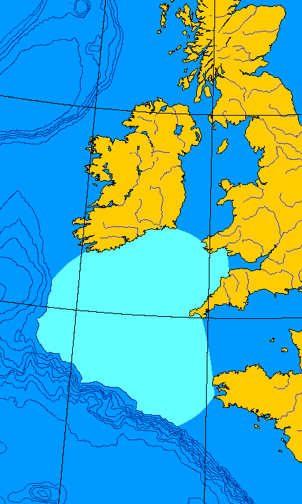
English: Map of the Celtic Sea. I made this file from a public domain original, generated at OMC.
Français : Carte de la Mer celtique. J'ai fait ce fichier-ci depuis une ébauche en domaine publique, générée à OMC. QuartierLatin1968 00:08, 15 Jun 2005 (UTC)
Licence
| This work has been released into the public domain by its author, QuartierLatin1968. This applies worldwide. In some countries this may not be legally possible; if so: |
Faila hronoloģija
Uzklikšķini uz datums/laiks kolonnā esošās saites, lai apskatītos, kā šis fails izskatījās tad.
| Datums/Laiks | Attēls | Izmēri | Dalībnieks | Komentārs | |
|---|---|---|---|---|---|
| tagadējais | 2005. gada 15. jūnijs, plkst. 03.08 | | 431 × 719 (24 KB) | QuartierLatin1968 | {{PD-user}} *{{en}} Map of the Celtic Sea. I made this file from a public domain original, generated at [http://www.aquarius.geomar.de/omc/make_map.html OMC]. *{{fr}} Carte de la Mer celtique. J'ai fait ce fichier-ci depuis une ébauche en domaine publiqu |
Faila lietojums
Šo failu neizmanto nevienā lapā.
Globālais faila lietojums
Šīs Vikipēdijas izmanto šo failu:
- Izmantojums an.wikipedia.org
- Izmantojums az.wikipedia.org
- Izmantojums bat-smg.wikipedia.org
- Izmantojums be-tarask.wikipedia.org
- Izmantojums be.wikipedia.org
- Izmantojums bg.wikipedia.org
- Izmantojums bn.wikipedia.org
- Izmantojums ca.wikipedia.org
- Izmantojums ckb.wikipedia.org
- Izmantojums cy.wikipedia.org
- Izmantojums da.wikipedia.org
- Izmantojums de.wikipedia.org
- Izmantojums en.wikipedia.org
- Izmantojums eo.wikipedia.org
- Izmantojums es.wikipedia.org
- Izmantojums et.wikipedia.org
- Izmantojums fa.wikipedia.org
- Izmantojums fr.wikipedia.org
- Izmantojums fy.wikipedia.org
- Izmantojums gv.wikipedia.org
- Izmantojums he.wikipedia.org
- Izmantojums hu.wikipedia.org
- Izmantojums hy.wikipedia.org
- Izmantojums it.wikipedia.org
- Izmantojums ja.wikipedia.org
- Izmantojums ka.wikipedia.org
- Izmantojums kk.wikipedia.org
- Izmantojums ko.wikipedia.org
- Izmantojums ku.wikipedia.org
- Izmantojums kw.wikipedia.org
- Izmantojums la.wikipedia.org
- Izmantojums lmo.wikipedia.org
- Izmantojums lt.wikipedia.org
- Izmantojums mn.wikipedia.org
- Izmantojums nn.wikipedia.org
- Izmantojums no.wikipedia.org
- Izmantojums oc.wikipedia.org
- Izmantojums pl.wikipedia.org
- Izmantojums pnb.wikipedia.org
- Izmantojums pt.wikipedia.org
- Izmantojums ro.wikipedia.org
- Izmantojums ru.wikipedia.org
- Izmantojums simple.wikipedia.org
- Izmantojums sk.wikipedia.org
- Izmantojums vi.wikipedia.org
- Izmantojums war.wikipedia.org
- Izmantojums xmf.wikipedia.org