
Attēls:Medieval Livonia 1260.svg

Size of this PNG preview of this SVG file: 554 × 600 pikseļi. Citi izmēri: 222 × 240 pikseļi | 443 × 480 pikseļi | 709 × 768 pikseļi | 946 × 1 024 pikseļi | 1 891 × 2 048 pikseļi | 955 × 1 034 pikseļi.
Sākotnējais fails (SVG fails, definētais izmērs 955 × 1 034 pikseļi, faila izmērs: 734 KB)
| Šis fails ir no Vikikrātuves. Tā apraksts no attēla lapas Vikikrātuvē ir parādīts zemāk. Vikikrātuve ir brīvi licencēta failu krātuve. Tu vari tai palīdzēt. |
Kopsavilkums
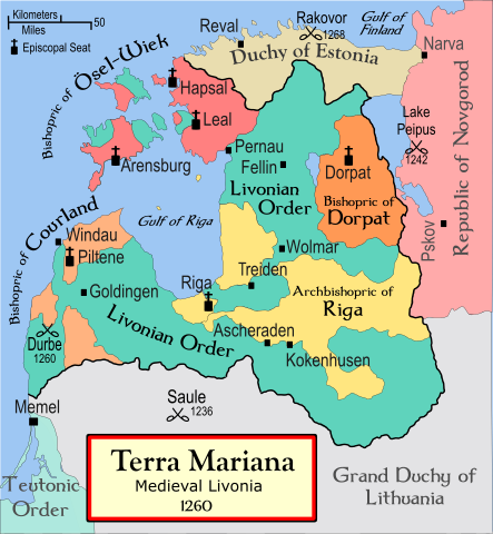
| Apraksts | A political map of the Medieval Livonia, circa 1260, along with surrounding areas |
| Datums | 2008. gada 13. novembris (original upload date) |
| Avots | No machine-readable source provided. Own work assumed (based on copyright claims). |
| Autors | No machine-readable author provided. Termer assumed (based on copyright claims). |
| Citas versijas | Magyar |
Foreign language versions
References
- Turnbull, Stephen (2004. gada) Crusader Castles of the Teutonic Knights (2), Osprey Publishing ISBN 1841767123
- Bjorklund, Oddvar; Holmboe, Haakon; Rohr, Anders (1970) Historical Atlas of the World, Barnes & Noble, NY, SBN: 389-00253-4.
- This 500 year old map of Lithuania, from UNESCO
- WHKMLA Historical Atlas - Estonia, accessed on November 2, 2006.
Licence
Es, šī darba autortiesību īpašnieks, publicēju to saskaņā ar šo licenci:

|
Ir dota atļauja kopēt, izplatīt un/vai pārveidot šo dokumentu saskaņā ar GNU brīvās dokumentācijas licences, versijas 1.2 vai jebkuras vēlākas versijas, ko publiskojis Brīvās programmatūras fonds nosacījumiem; bez nemainīgajām sadaļā, priekšējā un aizmugurēja'vāka tekstiem. Licences kopija ir iekļauta sadaļā ar nosaukumu GNU brīvās dokumentācijas licence. |
| Šis fails tiek izplatīts saskaņā ar licences Creative Commons Atsauce-Līdzīgi Noteikumi 3.0 Vispārējiem noteikumiem. | ||
| ||
| This licensing tag was added to this file as part of the GFDL licensing update. |
Faila hronoloģija
Uzklikšķini uz datums/laiks kolonnā esošās saites, lai apskatītos, kā šis fails izskatījās tad.
| Datums/Laiks | Attēls | Izmēri | Dalībnieks | Komentārs | |
|---|---|---|---|---|---|
| tagadējais | 2008. gada 13. novembris, plkst. 06.40 | | 955 × 1 034 (734 KB) | Termer | == Summary == A political map of the Livonian Confederation, circa 1260, along with surrounding areas. *'''Comment''': The Livonian Confederation was established in 1418! The map needs a new name. I'd suggest '''Old Livonia |
Faila lietojums
Šo failu izmanto šajās 92 lapās:
- 1205. gada Ropažu kauja
- 1206. gada Salaspils aplenkums
- 1206. gada kauja pie Salaspils
- 1206. gada kauja pie Turaidas
- 1208. gada Sēlpils aplenkums
- Aizkraukles kauja (1229)
- Aizkraukles kauja (1279)
- Autines sacelšanās un kauja pie Satezeles
- Beverīnas aplenkums
- Beverīnas aplenkums un atbildes karagājieni (1211)
- Cēsu kauja (1245)
- Dobeles aplenkums (1280)
- Durbes kauja
- Dāņu Igaunija
- Dāņu karagājiens uz Sāmsalu (1222)
- Embūtes kauja (1244)
- Garozas kauja
- Igaunija
- Igaunijas vēsture
- Igauņu karagājieni uz Līvzemi un Tālavu (1215)
- Igauņu sacelšanās un kauja pie Vīlandes (1223)
- Igauņu un krievu karagājiens uz Senlatviju (1223)
- Karagājieni uz Novgorodu un Ingriju (1222)
- Karagājieni uz Zemgali (1271)
- Karagājiens uz Abavas kuršu zemi (1229)
- Karagājiens uz Izborsku un Pleskavu (1240)
- Karagājiens uz Jersiku (1209)
- Karagājiens uz Kernavi (1279)
- Karagājiens uz Kursu un Dzintares kauja (1261)
- Karagājiens uz Kursu un Klaipēdas dibināšana (1252)
- Karagājiens uz Kursu un Kuldīgas nodibināšana (1242)
- Karagājiens uz Lietuvu (1208)
- Karagājiens uz Nalseni, Lietuvu un Žemaitiju (1250)
- Karagājiens uz Nalseni (1235)
- Karagājiens uz Nalseni (1245)
- Karagājiens uz Zemgali (1228)
- Karagājiens uz Zemgali (1250)
- Karagājiens uz Zemgali (1265)
- Karuzes kauja
- Kauja pie Bukultiem
- Kauja pie Daugavgrīvas (1263)
- Kauja pie Dinaburgas pils (ap 1275)
- Kauja pie Dobes (1260)
- Kauja pie Dubnas (ap 1273)
- Kauja pie Griezes (1264)
- Kauja pie Heiligenbergas (Svētkalna) pils
- Kauja pie Lielvārdes (1262)
- Kauja pie Puides (1218)
- Kauja pie Skodas (1259)
- Kauja pie Turaidas (1298)
- Kokneses nodedzināšana (1208)
- Krievu karagājiens uz Igauniju (1223)
- Krievu karagājiens uz Senlatviju (1218)
- Krievu un lietuviešu karagājieni uz Cēsīm, Turaidu un Imeru (1221)
- Kuršu piļu nodedzināšana (1263)
- Kuršu sacelšanās (1260)
- Kuršu un zemgaļu uzbrukums Daugavgrīvai (1228)
- Kuršu uzbrukumi Klaipēdai (1263)
- Ledus kauja
- Letu karagājieni uz Krievzemi (1218—1219)
- Lietuviešu karagājieni uz Tālavu un Lielvārdi (1213)
- Lietuviešu karagājiens uz Kursu (1245)
- Lietuviešu un līvu karagājiens uz Rīgu (1204)
- Livonijas bīskapija
- Livonijas krusta kari
- Livonijas pilsoņu karš
- Mažeikas karagājiens uz Talsiem
- Mestra Kūno karagājiens uz Zemgali
- Mežotnes aplenkumi (1219—1220)
- Mindauga karagājiens uz Cēsīm (1262)
- Mītavas pils uzcelšana
- Nameiša karagājiens uz Rīgu (1280)
- Novgorodas krievu karagājiens uz Tērbatu (1262)
- Ordeņa karaspēka sakāve Zemgalē (1264)
- Otrais karagājiens uz Jersiku (1214)
- Pleskavas aplenkums (1269)
- Polockas, Jersikas un lietuviešu karagājiens uz Līvzemi (1203)
- Rakveres kauja
- Rīgas arhibīskapija
- Saules kauja
- Sidabrenes nopostīšana pēc žemaišu iebrukuma Līvzemē
- Skarjota iebrukums Rīgas arhibīskapijā
- Svētā Matīsa dienas kauja
- Trešais karagājiens uz Jersiku (1215)
- Tērvetes aplenkums (1281)
- Tērvetes aplenkums un Dobes pils uzcelšana (1259)
- Tērvetes pils atbrīvošana (1279)
- Uzbrukumi Dobelei (1280)
- Vārtājas aplenkums (1259)
- Zemgales galīgā nopostīšana
- Zemgaļu uzbrukums Rīgai
- Diskusija:Pirmais karagājiens uz Sontaganu (1211)
Globālais faila lietojums
Šīs Vikipēdijas izmanto šo failu:
- Izmantojums af.wikipedia.org
- Izmantojums ar.wikipedia.org
- Izmantojums bat-smg.wikipedia.org
- Izmantojums ba.wikipedia.org
- Izmantojums be-tarask.wikipedia.org
- Izmantojums be.wikipedia.org
- Izmantojums bg.wikipedia.org
- Izmantojums br.wikipedia.org
- Izmantojums ca.wikipedia.org
- Izmantojums cs.wikipedia.org
- Izmantojums da.wikipedia.org
Skatīt šī faila pilno globālo izmantojumu.