
Attēls:Mount Rainier 5917s.JPG

Šī priekšskata izmērs: 709 × 600 pikseļi. Citi izmēri: 284 × 240 pikseļi | 567 × 480 pikseļi | 908 × 768 pikseļi | 1 210 × 1 024 pikseļi | 2 420 × 2 048 pikseļi | 4 920 × 4 163 pikseļi.
Sākotnējais fails (4 920 × 4 163 pikseļi, faila izmērs: 4,95 MB, MIME tips: image/jpeg)
| Šis fails ir no Vikikrātuves. Tā apraksts no attēla lapas Vikikrātuvē ir parādīts zemāk. Vikikrātuve ir brīvi licencēta failu krātuve. Tu vari tai palīdzēt. |
| Apraksts |
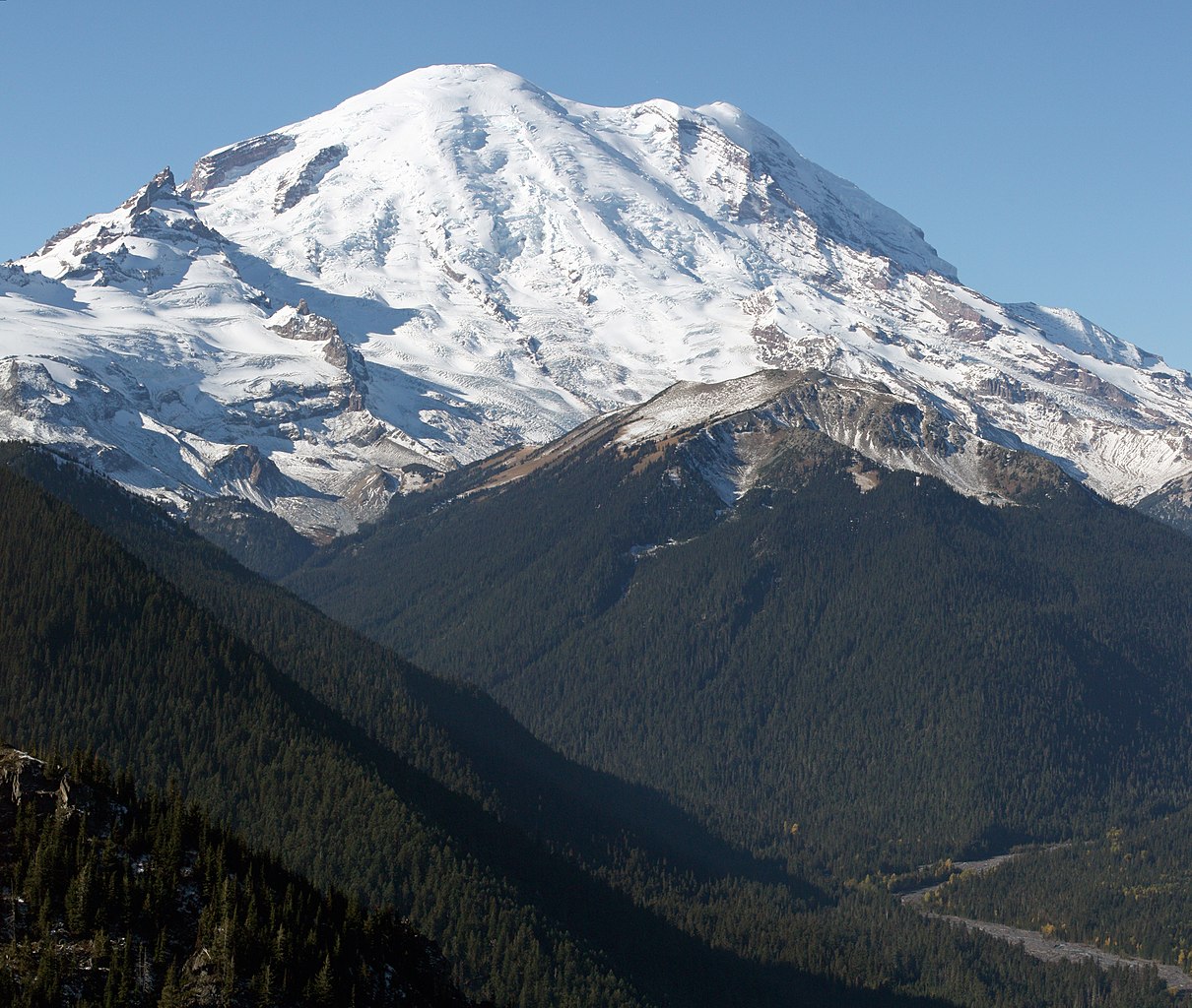
English: Mount Rainier with its main summit, Columbia Crest (14410 feet) at the center. Emmons Glacier covers most of the visible flank of the mountain. Ingraham Glacier (left) is between Gibraltar Rock (12660 feet) high on the left skyline and Disappointment Cleaver. Left of Gibraltar Rock is sharp pointed Little Tahoma (11138 feet) with Frying Pan Glacier on its flank. It is the source of Frying Pan Creek in the valley left of forested and rounded Goat Island Mountain, in front of the Emmons Glacier. Liberty Cap (14112 feet) is visible on the right center skyline behind Russell Cliff. Curtis Ridge descends to the right from Russell Cliff. Winthrop Glacier flows right below Curtis Ridge and behind shallow Steamboat Prow (9680 feet) with the small Inter Glacier on its northeast face. The White River comes from the Emmons Glacier and flows around the right side of Goat Island Mountain in the watercourse visible below right.
Esperanto: monto Rainier vidata de oriento |
| Datums | 2008. gada 22. oktobris, 11:19:11 −07:00 |
| Avots | Paša darbs |
| Autors | Walter Siegmund (talk) |
| Citas versijas |
|


| Camera location | | View this and other nearby images on: OpenStreetMap |
|---|
- Location source: Garmin GPSmap 60CSx
- Location Datum: WGS84
- Viewpoint location: Crystal Lakes Trail, Mount Rainier National Park
- Viewpoint elevation: 1732 meter (5684 ft)
- View direction: West-southwest
- Camera: Canon EOS DIGITAL REBEL XSi
- Exposure Time: 1/800
- F Number: f/11.0
- Focal Length: 70.0
- ISO Speed Rating: 400
This image was created with Hugin.
| This is a retouched picture, which means that it has been digitally altered from its original version. Modifications: Stitched two images; adjusted levels and color balance; please see other versions in the information template for the originals. Modifications made by Wsiegmund.
|
©2009 Walter Siegmund
Licence
Es, šī darba autortiesību īpašnieks, publicēju to saskaņā ar šīm licencēm:

|
Ir dota atļauja kopēt, izplatīt un/vai pārveidot šo dokumentu saskaņā ar GNU brīvās dokumentācijas licences, versijas 1.2 vai jebkuras vēlākas versijas, ko publiskojis Brīvās programmatūras fonds nosacījumiem; bez nemainīgajām sadaļā, priekšējā un aizmugurēja'vāka tekstiem. Licences kopija ir iekļauta sadaļā ar nosaukumu GNU brīvās dokumentācijas licence. |
This file is licensed under the Creative Commons Attribution-Share Alike 3.0 Unported, 2.5 Generic, 2.0 Generic and 1.0 Generic license.
- Jūs varat brīvi:
- koplietot – kopēt, izplatīt un pārraidīt darbu
- remiksēt – pielāgot darbu
- Saskaņā ar šādiem nosacījumiem:
- atsaucoties – Tev ir jānorāda autors, saite uz licenci un to, vai veiktas kādas izmaiņas. To var darīt jebkādā saprātīgā veidā, bet ne tādā, kas norādītu, ka licencētājs atbalsta tevi vai veidu, kā tu izmanto šo darbu.
- nemainot licenci – Ja tu miksē, pārveido vai izmanto materiālu, tev savs devums jāpublicē ar to pašu vai saderīgu licenci kā oriģināls.
Jūs varat izvēlēties licenci pēc jūsu vēlmes.
Faila hronoloģija
Uzklikšķini uz datums/laiks kolonnā esošās saites, lai apskatītos, kā šis fails izskatījās tad.
| Datums/Laiks | Attēls | Izmēri | Dalībnieks | Komentārs | |
|---|---|---|---|---|---|
| tagadējais | 2009. gada 21. marts, plkst. 08.27 | | 4 920 × 4 163 (4,95 MB) | Wsiegmund | Removed dust spots |
| 2009. gada 13. marts, plkst. 07.22 |  | 4 920 × 4 163 (4,95 MB) | Wsiegmund | {{Information |Description = {{en|Mount Rainier with its main summit, Columbia Crest (14410 feet) at the center. Emmons Glacier covers most of the visible flank of the mountain. Ingraham Glacier (left) is between Gibraltar Rock (12660 feet) high on th |
Faila lietojums
Šo failu izmanto šajās 2 lapās:
Globālais faila lietojums
Šīs Vikipēdijas izmanto šo failu:
- Izmantojums ar.wikipedia.org
- Izmantojums arz.wikipedia.org
- Izmantojums bn.wikipedia.org
- Izmantojums ca.wikipedia.org
- Izmantojums ceb.wikipedia.org
- Izmantojums cs.wikipedia.org
- Izmantojums de.wikipedia.org
- Izmantojums el.wikipedia.org
- Izmantojums en.wikipedia.org
- Pacific Northwest
- Dixy Lee Ray
- List of mountain peaks of North America
- List of National Historic Landmarks in Washington (state)
- List of the most isolated major summits of the United States
- Talk:Mount Rainier/Archive 1
- User talk:Hike395/Archive 10
- List of ultras of North America
- List of the most prominent summits of the United States
- List of the major 100-kilometer summits of North America
- Wikipedia:Teahouse/Guest book/Archive 1
- User:Ecpiandy/Washington (state)
- List of the highest major summits of North America
- List of the highest major summits of the United States
- Izmantojums en.wikiversity.org
- Izmantojums en.wikivoyage.org
- Izmantojums eo.wikipedia.org
- Izmantojums es.wikipedia.org
- Izmantojums es.wikivoyage.org
- Izmantojums et.wikipedia.org
- Izmantojums eu.wikipedia.org
- Izmantojums frr.wikipedia.org
- Izmantojums fr.wikipedia.org
- Mont Saint Helens
- Mont Rainier
- Mont Shasta
- Chaîne des Cascades
- Mont Hood
- Mont Adams
- Mont Baker
- Pic Glacier
- Three Sisters (Oregon)
- Pic Lassen
- Medicine Lake (volcan)
- Portail:États-Unis/Articles de qualité
- Mont Washington (Oregon)
- Wikipédia:Lumière sur/Mai 2008
- Wikipédia:Lumière sur/Mont Rainier
- Wikipédia:Sélection/Géographie
- Wikipédia:Sélection/Volcanisme
- Mont Thielsen
Skatīt šī faila pilno globālo izmantojumu.