
Attēls:Neckar river watershed.png
Šī priekšskata izmērs: 484 × 600 pikseļi. Citi izmēri: 194 × 240 pikseļi | 514 × 637 pikseļi.
Sākotnējais fails (514 × 637 pikseļi, faila izmērs: 14 KB, MIME tips: image/png)
| Šis fails ir no Vikikrātuves. Tā apraksts no attēla lapas Vikikrātuvē ir parādīts zemāk. Vikikrātuve ir brīvi licencēta failu krātuve. Tu vari tai palīdzēt. |

|
This map image could be re-created using vector graphics as an SVG file. This has several advantages; see Commons:Media for cleanup for more information. If an SVG form of this image is available, please upload it and afterwards replace this template with
{{vector version available|new image name}}.
It is recommended to name the SVG file “Neckar river watershed.svg”—then the template Vector version available (or Vva) does not need the new image name parameter. |
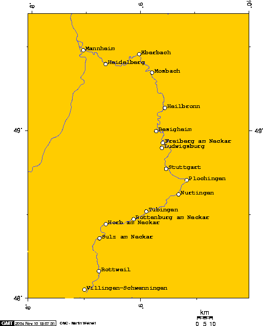
Watershed of the Neckar River
Source: Englis wikipedia (see interwiki)
The author (Geo Swan) declares this image GFDL. Uploaded 2004-11-09T03:41:50.

|
Ir dota atļauja kopēt, izplatīt un/vai pārveidot šo dokumentu saskaņā ar GNU brīvās dokumentācijas licences, versijas 1.2 vai jebkuras vēlākas versijas, ko publiskojis Brīvās programmatūras fonds nosacījumiem; bez nemainīgajām sadaļā, priekšējā un aizmugurēja'vāka tekstiem. Licences kopija ir iekļauta sadaļā ar nosaukumu GNU brīvās dokumentācijas licence. |
| Šis fails tiek izplatīts saskaņā ar licences Creative Commons Atsauce-Līdzīgi Noteikumi 3.0 Vispārējiem noteikumiem. | ||
| ||
| This licensing tag was added to this file as part of the GFDL licensing update. |
| I, the copyright holder of this work, release this work into the public domain. This applies worldwide. In some countries this may not be legally possible; if so: I grant anyone the right to use this work for any purpose, without any conditions, unless such conditions are required by law. |
The author says:
I used this online map creation tool to create this map. In case it becomes necessary to modify this map these are the longitude and latitude I used to create this map. Geo Swan 04:07, 9 Nov 2004 (UTC)
- 8.4800,48.0553, Villingen-Schwenningen
- 8.6281,48.1667, Rottweil
- 8.6318,48.3624, Sulz am Neckar
- 8.6900,48.4465, Horb am Neckar
- 8.9377,48.4769, Rottenburg am Neckar
- 9.0521,48.5229, Tübingen
- 9.3426,48.6246, Nurtingen
- 9.4173,48.7098, Plochingen
- 9.2000,48.7772, Stuttgart
- 9.1934,48.9020, Ludwigsburg
- 9.2025,48.9324, Freiberg am Neckar
- 9.1421,49.0023, Besigheim
- 9.2221,49.1416, Heilbronn
- 9.1459,49.3520, Mosbach
- 8.9871,49.4624, Eberbach
- 8.6802,49.4019, Heidelberg
- 8.4757,49.4845, Mannheim
Faila hronoloģija
Uzklikšķini uz datums/laiks kolonnā esošās saites, lai apskatītos, kā šis fails izskatījās tad.
| Datums/Laiks | Attēls | Izmēri | Dalībnieks | Komentārs | |
|---|---|---|---|---|---|
| tagadējais | 2004. gada 13. novembris, plkst. 19.51 | | 514 × 637 (14 KB) | Mschlindwein | Neckar Watershed |
Faila lietojums
Šo failu izmanto šajā 1 lapā:
Globālais faila lietojums
Šīs Vikipēdijas izmanto šo failu:
- Izmantojums ar.wikipedia.org
- Izmantojums azb.wikipedia.org
- Izmantojums de.wikipedia.org
- Izmantojums de.wiktionary.org
- Izmantojums el.wikipedia.org
- Izmantojums en.wikipedia.org
- Izmantojums eo.wikipedia.org
- Izmantojums fa.wikipedia.org
- Izmantojums fi.wikipedia.org
- Izmantojums fr.wikipedia.org
- Izmantojums gl.wikipedia.org
- Izmantojums hu.wikipedia.org
- Izmantojums id.wikipedia.org
- Izmantojums it.wikipedia.org
- Izmantojums jv.wikipedia.org
- Izmantojums lmo.wikipedia.org
- Izmantojums pl.wikipedia.org
- Izmantojums pt.wikipedia.org
- Izmantojums tr.wikipedia.org
- Izmantojums vi.wikipedia.org