
Attēls:Utrecht position.svg

Size of this PNG preview of this SVG file: 200 × 236 pikseļi. Citi izmēri: 203 × 240 pikseļi | 407 × 480 pikseļi | 651 × 768 pikseļi | 868 × 1 024 pikseļi | 1 736 × 2 048 pikseļi.
Sākotnējais fails (SVG fails, definētais izmērs 200 × 236 pikseļi, faila izmērs: 157 KB)
| Šis fails ir no Vikikrātuves. Tā apraksts no attēla lapas Vikikrātuvē ir parādīts zemāk. Vikikrātuve ir brīvi licencēta failu krātuve. Tu vari tai palīdzēt. |
Kopsavilkums
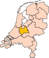
| Apraksts | Location of the province of Utrecht in the Netherlands. |
| Datums | |
| Avots | Own work, based on freely available GIS data |
| Autors | User:Mtcv |
| Atļauja: (Šī faila izmantošana citur) |
Data: attribution required; my work: PD |
| Citas versijas | I attempted to make an svg version of Image:Utrecht-Position.png (with less simplified boundaries) |
Clickable version

Licence

|
The copyright holder of this file, Centraal Bureau voor de Statistiek, allows anyone to use it for any purpose, provided that the copyright holder is properly attributed. Redistribution, derivative work, commercial use, and all other use is permitted. |
Atsauce:
|
| Annotations | This image is annotated: View the annotations at Commons |


Faila hronoloģija
Uzklikšķini uz datums/laiks kolonnā esošās saites, lai apskatītos, kā šis fails izskatījās tad.
| Datums/Laiks | Attēls | Izmēri | Dalībnieks | Komentārs | |
|---|---|---|---|---|---|
| tagadējais | 2019. gada 2. marts, plkst. 20.20 | | 200 × 236 (157 KB) | Thayts | update |
| 2006. gada 3. oktobris, plkst. 03.49 |  | 200 × 236 (158 KB) | Mtcv | {{Information| |Description=Location of the province of Noord-Holland (North Holland) in the Netherlands. |Source=Own work, based on freely available GIS data |Date=2006-10-03 |Author=User:Mtcv |Permission=Data: attribution required; my work: PD |othe |
Faila lietojums
Šo failu neizmanto nevienā lapā.
Globālais faila lietojums
Šīs Vikipēdijas izmanto šo failu:
- Izmantojums ar.wikipedia.org
- Izmantojums be-tarask.wikipedia.org
- Izmantojums be.wikipedia.org
- Izmantojums cy.wikipedia.org
- Izmantojums en.wikipedia.org
Skatīt šī faila pilno globālo izmantojumu.