
Attēls:Great Fire of London Map.png

Šī priekšskata izmērs: 800 × 471 pikseļi. Citi izmēri: 320 × 188 pikseļi | 640 × 376 pikseļi | 1 024 × 602 pikseļi | 1 280 × 753 pikseļi | 2 550 × 1 500 pikseļi.
Sākotnējais fails (2 550 × 1 500 pikseļi, faila izmērs: 342 KB, MIME tips: image/png)
| Šis fails ir no Vikikrātuves. Tā apraksts no attēla lapas Vikikrātuvē ir parādīts zemāk. Vikikrātuve ir brīvi licencēta failu krātuve. Tu vari tai palīdzēt. |

|
This city map image could be re-created using vector graphics as an SVG file. This has several advantages; see Commons:Media for cleanup for more information. If an SVG form of this image is available, please upload it and afterwards replace this template with
{{vector version available|new image name}}.
It is recommended to name the SVG file “Great Fire of London Map.svg”—then the template Vector version available (or Vva) does not need the new image name parameter. |
Kopsavilkums
| Apraksts |
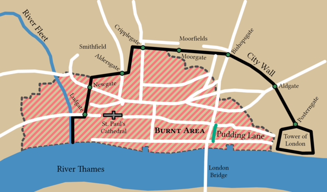
English: Spread of the Great Fire of London based on Tinniswood (2003, p. 97) and Hollar (1666). This map is a part of a remake of a mapseries made by Bunchofgrapes in 2006 to fix accessability issues. The orignal map was traced in ArcGIS Pro to produce this one and with consulation from reliable sources. |
||
| Datums | |||
| Avots |
Šis fails tika iegūts no: Great fire of london map.png: |
||
| Izveidotājs |
|
||
| Credit line | © Bunchofgrapes and Tom Fish // Creative Commons CC BY-SA 3.0 | ||
| Atļauja: (Šī faila izmantošana citur) |
|
||
| Georeferencing | |||
| Archival data | |||
| artwork-references |
|
||
| PNG veidošana | This map was created with ArcGIS Pro. |
||
Licence
Šis fails tiek izplatīts saskaņā ar licences Creative Commons Atsauce-Līdzīgi Noteikumi 3.0 Vispārējiem noteikumiem.
- Jūs varat brīvi:
- koplietot – kopēt, izplatīt un pārraidīt darbu
- remiksēt – pielāgot darbu
- Saskaņā ar šādiem nosacījumiem:
- atsaucoties – Tev ir jānorāda autors, saite uz licenci un to, vai veiktas kādas izmaiņas. To var darīt jebkādā saprātīgā veidā, bet ne tādā, kas norādītu, ka licencētājs atbalsta tevi vai veidu, kā tu izmanto šo darbu.
- nemainot licenci – Ja tu miksē, pārveido vai izmanto materiālu, tev savs devums jāpublicē ar to pašu vai saderīgu licenci kā oriģināls.
Faila hronoloģija
Uzklikšķini uz datums/laiks kolonnā esošās saites, lai apskatītos, kā šis fails izskatījās tad.
| Datums/Laiks | Attēls | Izmēri | Dalībnieks | Komentārs | |
|---|---|---|---|---|---|
| tagadējais | 2022. gada 6. jūnijs, plkst. 14.52 | | 2 550 × 1 500 (342 KB) | Guerillero | Fix small issues |
| 2021. gada 30. decembris, plkst. 18.33 |  | 2 125 × 1 250 (282 KB) | Guerillero | == {{int:filedesc}} == {{User:Guerillero/Template |Description= {{en|Spread of the Great Fire of London}} |Source={{Derived from|Great fire of london map.png|display=50}} |Author={{u|Bunchofgrapes}} |Date= 29 December 2021 }} == {{int:license-header}} == {{Cc-by-sa-3.0}} Category:Maps of the Great Fire of London |
Faila lietojums
Šo failu izmanto šajā 1 lapā:
Globālais faila lietojums
Šīs Vikipēdijas izmanto šo failu:
- Izmantojums azb.wikipedia.org
- Izmantojums en.wikipedia.org
- Izmantojums pt.wikipedia.org
- Izmantojums sl.wikipedia.org