
Attēls:Sirocco wind1.jpg
Augstāka izšķirtspēja nav pieejama.
Sirocco_wind1.jpg (713 × 500 pikseļi, faila izmērs: 41 KB, MIME tips: image/jpeg)
| Šis fails ir no Vikikrātuves. Tā apraksts no attēla lapas Vikikrātuvē ir parādīts zemāk. Vikikrātuve ir brīvi licencēta failu krātuve. Tu vari tai palīdzēt. |
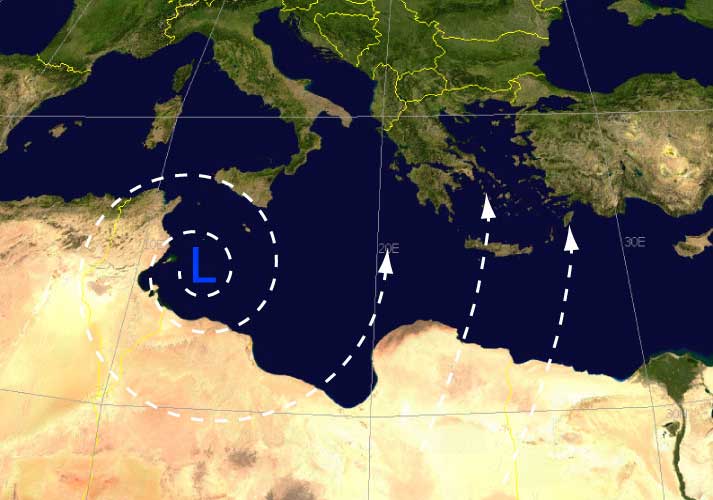
Kopsavilkums
Sirocco wind diagram by Piotr Flatau
The background was generated using (open source) NASA Worldwind program [1] and Adobe Photoshop and Adobe Illustrator was used to add other elements. Pflatau 21:09, 3 March 2006 (UTC)
| Object location | | View this and other nearby images on: OpenStreetMap |
|---|
Licence
| I, the copyright holder of this work, release this work into the public domain. This applies worldwide. In some countries this may not be legally possible; if so: I grant anyone the right to use this work for any purpose, without any conditions, unless such conditions are required by law. |
Faila hronoloģija
Uzklikšķini uz datums/laiks kolonnā esošās saites, lai apskatītos, kā šis fails izskatījās tad.
| Datums/Laiks | Attēls | Izmēri | Dalībnieks | Komentārs | |
|---|---|---|---|---|---|
| tagadējais | 2006. gada 6. februāris, plkst. 07.20 | | 713 × 500 (41 KB) | Pflatau | Sirocco wind diagram |
Faila lietojums
Šo failu izmanto šajā 1 lapā:
Globālais faila lietojums
Šīs Vikipēdijas izmanto šo failu:
- Izmantojums ar.wikipedia.org
- Izmantojums az.wikipedia.org
- Izmantojums be.wikipedia.org
- Izmantojums bh.wikipedia.org
- Izmantojums bn.wikipedia.org
- Izmantojums ckb.wikipedia.org
- Izmantojums de.wikipedia.org
- Izmantojums el.wikipedia.org
- Izmantojums en.wikipedia.org
- Izmantojums eo.wikipedia.org
- Izmantojums es.wikipedia.org
- Izmantojums fa.wikipedia.org
- Izmantojums fi.wikipedia.org
- Izmantojums fr.wikipedia.org
- Izmantojums fr.wiktionary.org
- Izmantojums hr.wikipedia.org
- Izmantojums it.wikipedia.org
- Izmantojums it.wikiquote.org
- Izmantojums ja.wikibooks.org
- Izmantojums ka.wikipedia.org
- Izmantojums kk.wikipedia.org
- Izmantojums ko.wikipedia.org
- Izmantojums lt.wikipedia.org
- Izmantojums nn.wikipedia.org
- Izmantojums oc.wikipedia.org
- Izmantojums pl.wikipedia.org
- Izmantojums pl.wiktionary.org
- Izmantojums pt.wikipedia.org
- Izmantojums ru.wikipedia.org
- Izmantojums sq.wikipedia.org
- Izmantojums sv.wikipedia.org
- Izmantojums tr.wikipedia.org
- Izmantojums uk.wikipedia.org
- Izmantojums vi.wikipedia.org
- Izmantojums xmf.wikipedia.org