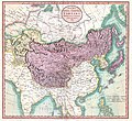
Attēls:1806 Cary Map of Tartary or Central Asia - Geographicus - Tartary-cary-1806.jpg

Lapas saturs netiek atbalstīts citās valodās.
Vikipēdijas lapa

Sākotnējais fails(5 000 × 4 569 pikseļi, faila izmērs: 8,57 MB, MIME tips: image/jpeg)

John Cary: A New Map of Mongolian & Independent Tartary , From the Latest Authorities.   (Wikidata search (Cirrus search) Wikidata query (SPARQL)  Create new Wikidata item based on this file)
Izpildītājs
John Cary  (–1835)  wikidata:Q3446124 s:en:Author:John Cary
 
Alternative names
J. Cary
Apraksts kartogrāfs, gravieris, mapseller, printseller un grafiķis
Dzimšanas/miršanas datums 1755. gada 23. februāris / 1754. gada Labot šo Vikidatos 1835. gada 16. augusts Labot šo Vikidatos
Dzimšanas/miršanas vieta Corsley Mortlake
Darba periods 1788. gada / 1793. gada / 1797. gada Labot šo Vikidatos
Darba vieta
Autoritatīvā vadība
artist QS:P170,Q3446124
Nosaukums
A New Map of Mongolian & Independent Tartary , From the Latest Authorities.
Apraksts
English: An exceptionally beautiful example of John Cary’s important 1806 map of Mongolian and Independent Tartary. Covers Central Asia from the Caspian Sea to Japan, extends as far north as the Obskaia Sea and as far south as India, Burma and the Philippines. Includes the modern day nations of Uzbekistan, Kazakhstan, Turkmenistan, Kirgizstan, Tajikistan and Mongolia. One of Cary’s most interesting maps. Central Asia, despite hundreds of years of passing trade on the Silk Routes, was still, at the turn of the century a largely unknown land. Cary attempts to show some of the Silk Route passages, especially to the north of the Gobi, but ultimately admits, “The Geography of these parts is extremely obscure.” All in all, one of the most interesting and few maps of Central Asia to appear in first years of the 19th century. Prepared in 1806 by John Cary for issue in his magnificent 1808 New Universal Atlas. (NOTE: The reproduction of the colors in this map appear to be incorrect, as Japan and Tibet were never part of Chinese Tartary yet appear to be the same color as it.)
Datums 1806. gada (dated)
Izmēri augstums: 18,5 in (46,9 cm); platums: 20 in (50,8 cm)
dimensions QS:P2048,18.5U218593
dimensions QS:P2049,20U218593
Accession number
Geographicus link: Tartary-cary-1806
Avots/Fotogrāfs

Cary, John, Cary's New Universal Atlas, containing distinct maps of all the principal states and kingdoms throughout the World. From the latest and best authorities extant. London: Printed for J. Cary, Engraver and Map-seller, No. 181, near Norfolk Street, Strand, 1808.

Atļauja:
(Šī faila izmantošana citur)
This is a faithful photographic reproduction of a two-dimensional, public domain work of art. The work of art itself is in the public domain for the following reason:
Public domain

This work is in the public domain in its country of origin and other countries and areas where the copyright term is the author's life plus 100 years or fewer.


You must also include a United States public domain tag to indicate why this work is in the public domain in the United States.
The official position taken by the Wikimedia Foundation is that "faithful reproductions of two-dimensional public domain works of art are public domain".
This photographic reproduction is therefore also considered to be in the public domain in the United States. In other jurisdictions, re-use of this content may be restricted; see Reuse of PD-Art photographs for details.
Citas versijas
Annotations
InfoField
This image is annotated: View the annotations at Commons

Captions

Pievieno vienas rindiņas aprakstu, ko šis fails attēlo

Šajā failā attēlotais

attēlo

image/jpeg

checksum angļu

3d7f1be3ae7a9539d26d91394bee37e7dc951779

data size angļu

8 990 511 Baits

4 569 pikselis

5 000 pikselis

Faila hronoloģija

Uzklikšķini uz datums/laiks kolonnā esošās saites, lai apskatītos, kā šis fails izskatījās tad.

Datums/LaiksAttēlsIzmēriDalībnieksKomentārs
tagadējais2019. gada 19. augusts, plkst. 11.562019. gada 19. augusts, plkst. 11.56 versijas sīktēls5 000 × 4 569 (8,57 MB)SoerfmBrightness, color
2011. gada 22. marts, plkst. 13.562011. gada 22. marts, plkst. 13.56 versijas sīktēls5 000 × 4 569 (7,81 MB)BotMultichillT{{subst:User:Multichill/Geographicus |link=http://www.geographicus.com/P/AntiqueMap/Tartary-cary-1806 |product_name=1806 Cary Map of Tartary or Central Asia |map_title=A New Map of Chinese & Independent Tartary , From the Latest Authorities. |description=

Šo failu izmanto šajā 1 lapā:

Globālais faila lietojums

Šīs Vikipēdijas izmanto šo failu:

Metadati