
Attēls:2022 Russian invasion of Ukraine.svg

Sākotnējais fails (SVG fails, definētais izmērs 2 199 × 1 478 pikseļi, faila izmērs: 3,7 MB)
| Šis fails ir no Vikikrātuves. Tā apraksts no attēla lapas Vikikrātuvē ir parādīts zemāk. Vikikrātuve ir brīvi licencēta failu krātuve. Tu vari tai palīdzēt. |
Rules for editing the map
|
| All edit warring, adding of unsourced information or performing a color change without consensus may result in the user being blocked. All contributions should first be discussed on the talk page. |
Kopsavilkums

|
This file may be updated to reflect new information. If you wish to use a specific version of the file without new updates being mirrored, please upload the required version as a separate file. |
| Apraksts |
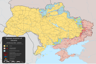
English: Krievijas 2022. gada iebrukums Ukrainā – bruņots konflikts, kas sākās 2022. gada 24. februārī, kad Krievijas bruņotie spēki iegāja Ukrainā [] |
||
| Datums | 2022. gada 24. februāris (first version) | ||
| Avots |
Own work based on: Russo-Ukrainian conflict (2014-2022).svg by Rr016 & Ukraine adm location map improved.svg by Yakiv Gluck
|
||
| Autors | Viewsridge | ||
| Citas versijas |
[]
|
||
| SVG veidošana | This map is translated using SVG switch elements: all translations are stored in the same file.
|


.gif)

.gif)


_en.png)
_vi.png)
_ru.png)
.svg)
This file is translated using SVG <switch> elements. All translations are stored in the same file! Learn more.
For most Wikipedia projects, you can embed the file normally (without a To translate the text into your language, you can use the SVG Translate tool. Alternatively, you can download the file to your computer, add your translations using whatever software you're familiar with, and re-upload it with the same name. You will find help in Graphics Lab if you're not sure how to do this. |
Licence
- Jūs varat brīvi:
- koplietot – kopēt, izplatīt un pārraidīt darbu
- remiksēt – pielāgot darbu
- Saskaņā ar šādiem nosacījumiem:
- atsaucoties – Tev ir jānorāda autors, saite uz licenci un to, vai veiktas kādas izmaiņas. To var darīt jebkādā saprātīgā veidā, bet ne tādā, kas norādītu, ka licencētājs atbalsta tevi vai veidu, kā tu izmanto šo darbu.
- nemainot licenci – Ja tu miksē, pārveido vai izmanto materiālu, tev savs devums jāpublicē ar to pašu vai saderīgu licenci kā oriģināls.
Faila hronoloģija
Uzklikšķini uz datums/laiks kolonnā esošās saites, lai apskatītos, kā šis fails izskatījās tad.
| Datums/Laiks | Attēls | Izmēri | Dalībnieks | Komentārs | |
|---|---|---|---|---|---|
| tagadējais | 2024. gada 17. aprīlis, plkst. 10.00 | | 2 199 × 1 478 (3,7 MB) | Physeters | Small updates per the ISW |
| 2024. gada 8. aprīlis, plkst. 10.38 |  | 2 199 × 1 478 (3,7 MB) | Physeters | Small updates per the ISW; add Synkivka, Kyslivka, Novoiehorivka, Terny, Heorhiivka, and Novomykhailivka | |
| 2024. gada 3. aprīlis, plkst. 08.33 |  | 2 199 × 1 478 (3,7 MB) | Physeters | Updates east of Avdiivka per the ISW | |
| 2024. gada 27. marts, plkst. 06.04 |  | 2 199 × 1 478 (3,7 MB) | Physeters | Small updates per the ISW | |
| 2024. gada 16. marts, plkst. 01.44 |  | 2 199 × 1 478 (3,7 MB) | Physeters | Small updates across the front per the ISW | |
| 2024. gada 9. marts, plkst. 05.31 |  | 2 199 × 1 478 (3,7 MB) | Physeters | Updates across the front per the ISW; correct previous zone of occupation in Chernihiv & Sumy Oblasts | |
| 2024. gada 29. februāris, plkst. 09.58 |  | 2 199 × 1 478 (3,7 MB) | Physeters | Updates in the east per the ISW | |
| 2024. gada 25. februāris, plkst. 09.32 |  | 2 199 × 1 478 (3,7 MB) | Physeters | Updates across the front per the ISW | |
| 2024. gada 20. februāris, plkst. 09.20 |  | 2 199 × 1 478 (3,69 MB) | Physeters | Updates across the front per the ISW; Robotyne is contested per the ISW | |
| 2024. gada 18. februāris, plkst. 11.52 |  | 2 199 × 1 478 (3,69 MB) | Physeters | Frontline updates per the ISW; Avdiivka falls to Russia per the Territorial Control List |
Faila lietojums
Šo failu izmanto šajās 7 lapās:
Globālais faila lietojums
Šīs Vikipēdijas izmanto šo failu:
- Izmantojums af.wikipedia.org
- Izmantojums als.wikipedia.org
- Izmantojums am.wikipedia.org
- Izmantojums ang.wikipedia.org
- Izmantojums an.wikipedia.org
- Izmantojums ar.wikipedia.org
- Izmantojums ary.wikipedia.org
- Izmantojums arz.wikipedia.org
- Izmantojums ast.wikipedia.org
- Izmantojums azb.wikipedia.org
- Izmantojums az.wikipedia.org
- Izmantojums bat-smg.wikipedia.org
- Izmantojums bcl.wikipedia.org
- Izmantojums be-tarask.wikipedia.org
- Izmantojums be.wikipedia.org
- Izmantojums bg.wikipedia.org
- Izmantojums bh.wikipedia.org
- Izmantojums bn.wikipedia.org
- Izmantojums br.wikipedia.org
- Izmantojums bs.wikipedia.org
- Izmantojums bxr.wikipedia.org
- Izmantojums ca.wikipedia.org
Skatīt šī faila pilno globālo izmantojumu.