
Attēls:Antalya districts.png
Šī priekšskata izmērs: 736 × 599 pikseļi. Citi izmēri: 295 × 240 pikseļi | 589 × 480 pikseļi | 954 × 777 pikseļi.
Sākotnējais fails (954 × 777 pikseļi, faila izmērs: 46 KB, MIME tips: image/png)
| Šis fails ir no Vikikrātuves. Tā apraksts no attēla lapas Vikikrātuvē ir parādīts zemāk. Vikikrātuve ir brīvi licencēta failu krātuve. Tu vari tai palīdzēt. |
Kopsavilkums
| Apraksts |
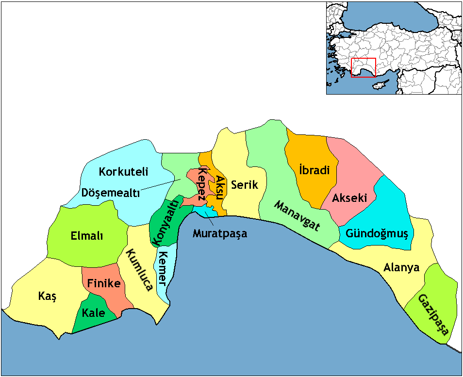
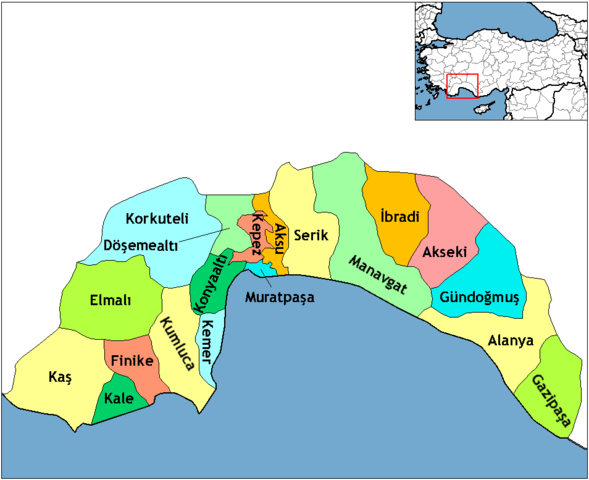
English: Map of the districts of Antalya province in Turkey. Created by Rarelibra 16:59, 1 December 2006 (UTC) for public domain use, using MapInfo Professional v8.5 and various mapping resources. Edited by One Homo Sapiens Corrected text where İ,Ş,ı,ğ,or ş occurs in name. Source: [statoids-com]. Increased font size and enhanced color differences among adjacent districts. |
| Datums | 2006. gada 1. decembris (original upload date) |
| Avots | No machine-readable source provided. Own work assumed (based on copyright claims). |
| Autors | No machine-readable author provided. Rarelibra assumed (based on copyright claims). |
Licence
| I, the copyright holder of this work, release this work into the public domain. This applies worldwide. In some countries this may not be legally possible; if so: I grant anyone the right to use this work for any purpose, without any conditions, unless such conditions are required by law. |
This image was intentionally uploaded with a border. Please do not remove the border. Upload a new version under a different filename without a border if you want a version without a border.
|
Faila hronoloģija
Uzklikšķini uz datums/laiks kolonnā esošās saites, lai apskatītos, kā šis fails izskatījās tad.
| Datums/Laiks | Attēls | Izmēri | Dalībnieks | Komentārs | |
|---|---|---|---|---|---|
| tagadējais | 2018. gada 19. februāris, plkst. 02.24 | | 954 × 777 (46 KB) | Effeietsanders | Removed border by cropping 10 % horizontally and 5 % vertically using CropTool with precise mode. |
| 2009. gada 1. janvāris, plkst. 22.18 |  | 1 056 × 816 (67 KB) | Onur | {{Information |Description= |Source= |Date= |Author= |Permission= |other_versions= }} | |
| 2008. gada 28. decembris, plkst. 23.43 |  | 1 056 × 816 (39 KB) | One Homo Sapiens | Corrected text where İ,Ş,ı,ğ,or ş occurs in name. Source: [statoids-com]. Increased font size and enhanced color differences among adjacent districts. | |
| 2006. gada 1. decembris, plkst. 19.59 |  | 1 056 × 816 (32 KB) | Rarelibra | Map of the districts of Antalya province in Turkey. Created by ~~~~ for public domain use, using MapInfo Professional v8.5 and various mapping resources. |
Faila lietojums
Šo failu neizmanto nevienā lapā.
Globālais faila lietojums
Šīs Vikipēdijas izmanto šo failu:
- Izmantojums azb.wikipedia.org
- Izmantojums az.wikipedia.org
- Izmantojums ba.wikipedia.org
- Izmantojums be.wikipedia.org
- Izmantojums br.wikipedia.org
- Izmantojums ca.wikipedia.org
- Izmantojums da.wikipedia.org
- Izmantojums de.wikipedia.org
- Alanya
- Antalya (Provinz)
- Gazipaşa
- Akseki
- Kumluca (Antalya)
- Vorlage:Navigationsleiste Landkreise der Provinz Antalya
- Serik (Landkreis)
- Korkuteli (Landkreis)
- Finike (Landkreis)
- Elmalı (Landkreis)
- İbradı (Landkreis)
- Kemer (Landkreis, Antalya)
- Kaş (Landkreis)
- Gündoğmuş
- Demre
- Aksu (Antalya)
- Döşemealtı
- Kepez (Antalya)
- Konyaaltı
- Muratpaşa
- Izmantojums diq.wikipedia.org
- Izmantojums en.wikipedia.org
Skatīt šī faila pilno globālo izmantojumu.