
Attēls:Arshakuni Armenia 150-en.svg

Size of this PNG preview of this SVG file: 800 × 470 pikseļi. Citi izmēri: 320 × 188 pikseļi | 640 × 376 pikseļi | 1 024 × 601 pikseļi | 1 280 × 751 pikseļi | 2 560 × 1 503 pikseļi | 2 717 × 1 595 pikseļi.
Sākotnējais fails (SVG fails, definētais izmērs 2 717 × 1 595 pikseļi, faila izmērs: 850 KB)
| Šis fails ir no Vikikrātuves. Tā apraksts no attēla lapas Vikikrātuvē ir parādīts zemāk. Vikikrātuve ir brīvi licencēta failu krātuve. Tu vari tai palīdzēt. |
Kopsavilkums
| Apraksts |
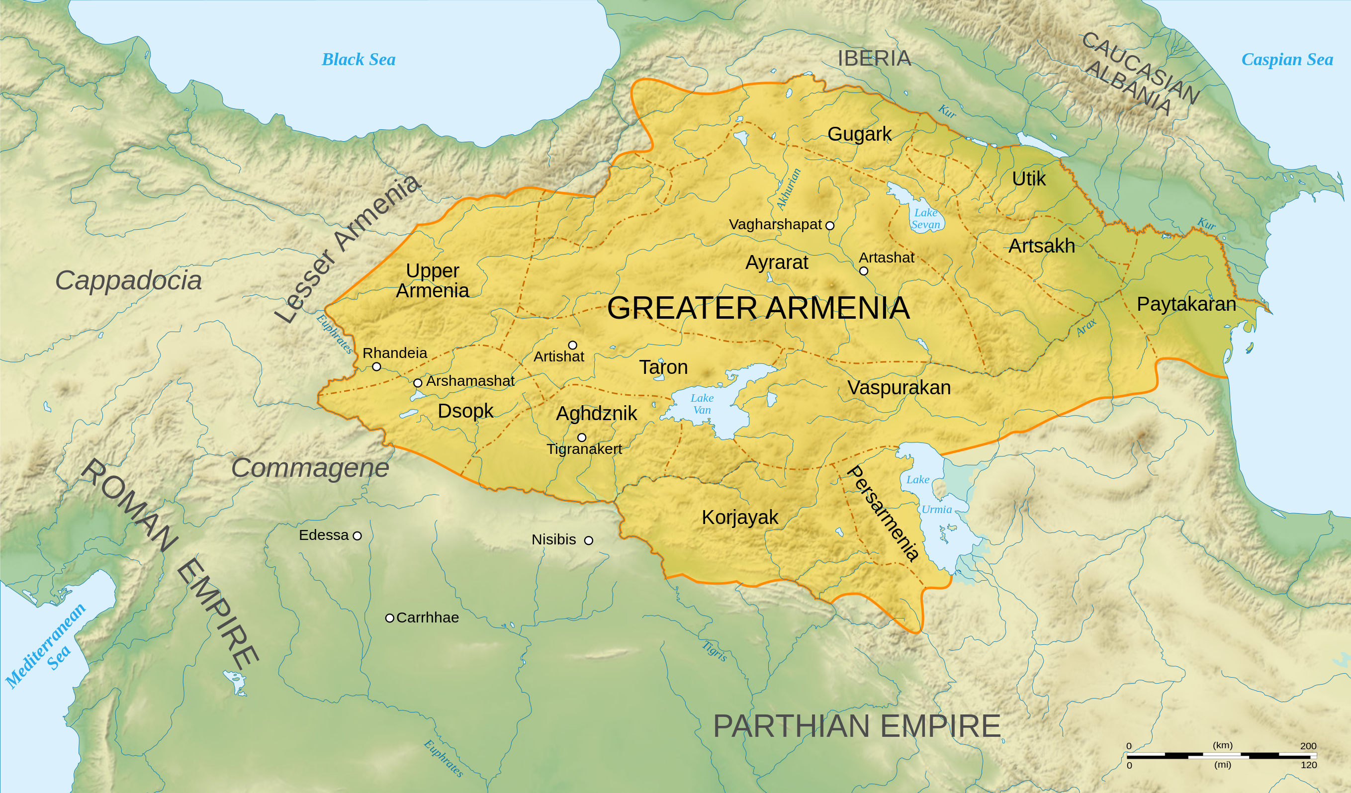
English: Map of Arshakuni Armenia, around the year 150 AD.
Français : Carte en anglais de l'Arménie Arsacide, vers l'an 150. |
||
| Datums | |||
| Avots |
Own work.
Sources :
Software used :
Autres données :
|
||
| Autors | Sémhur | ||
| Citas versijas |
[]
| ||
| Atsauce (required by the license) | © Sémhur / Wikimedia Commons / | ||
| SVG | W3C-validity not checked.
|
||
| Atelier graphique |


.png)


| Camera location | | View this and other nearby images on: OpenStreetMap |
|---|
Licence
Es, šī darba autortiesību īpašnieks, publicēju to saskaņā ar šīm licencēm:
| Copyleft: This work of art is free; you can redistribute it and/or modify it according to terms of the Free Art License. You will find a specimen of this license on the Copyleft Attitude site as well as on other sites. |
This file is licensed under the Creative Commons Attribution-Share Alike 4.0 International, 3.0 Unported, 2.5 Generic, 2.0 Generic and 1.0 Generic license.
- Jūs varat brīvi:
- koplietot – kopēt, izplatīt un pārraidīt darbu
- remiksēt – pielāgot darbu
- Saskaņā ar šādiem nosacījumiem:
- atsaucoties – Tev ir jānorāda autors, saite uz licenci un to, vai veiktas kādas izmaiņas. To var darīt jebkādā saprātīgā veidā, bet ne tādā, kas norādītu, ka licencētājs atbalsta tevi vai veidu, kā tu izmanto šo darbu.
- nemainot licenci – Ja tu miksē, pārveido vai izmanto materiālu, tev savs devums jāpublicē ar to pašu vai saderīgu licenci kā oriģināls.
Jūs varat izvēlēties licenci pēc jūsu vēlmes.
Faila hronoloģija
Uzklikšķini uz datums/laiks kolonnā esošās saites, lai apskatītos, kā šis fails izskatījās tad.
| Datums/Laiks | Attēls | Izmēri | Dalībnieks | Komentārs | |
|---|---|---|---|---|---|
| tagadējais | 2023. gada 30. jūnijs, plkst. 07.22 | | 2 717 × 1 595 (850 KB) | Luckie Luke | File uploaded using svgtranslate tool (https://svgtranslate.toolforge.org/). Added translation for fa. |
| 2023. gada 30. jūnijs, plkst. 04.54 |  | 2 717 × 1 595 (808 KB) | Luckie Luke | File uploaded using svgtranslate tool (https://svgtranslate.toolforge.org/). Added translation for fa. | |
| 2008. gada 12. janvāris, plkst. 15.47 |  | 2 717 × 1 595 (798 KB) | Sémhur | == Description == {{Information |Description= {{en| Map of Arshakuni Armenia, around the year 150 AD.}} {{fr| Carte en anglais de l'Arménie Arsacide, vers l'an 150.}} |Source=Own work. {{clr}} Sources : * Topographic background : [http://www2.jpl.nasa.go |
Faila lietojums
Šo failu izmanto šajā 1 lapā:
Globālais faila lietojums
Šīs Vikipēdijas izmanto šo failu:
- Izmantojums ar.wikipedia.org
- Izmantojums arz.wikipedia.org
- Izmantojums azb.wikipedia.org
- Izmantojums bg.wikipedia.org
- Izmantojums bn.wikipedia.org
- Izmantojums de.wikipedia.org
- Izmantojums diq.wikipedia.org
- Izmantojums el.wikipedia.org
- Χοσρόης Α΄ της Αρμενίας
- Τιριδάτης Β΄ της Αρμενίας
- Χοσρόης Β΄ της Αρμενίας
- Τιριδάτης Γ΄ της Αρμενίας
- Χοσρόης Γ΄ της Αρμενίας
- Τιράν της Αρμενίας
- Αρσάκης Β΄ της Αρμενίας
- Παπ της Αρμενίας
- Βαρασδάτης της Αρμενίας
- Αρσάκης Γ΄ της Αρμενίας
- Χοσρόης Δ΄ της Αρμενίας
- Βραχμσαπώρ της Αρμενίας
- Αρταξίας Δ΄ της Αρμενίας
- Τιγράνης ΣΤ΄ της Αρμενίας
- Τιριδάτης Α΄ της Αρμενίας
- Βολογέσης Γ΄ της Παρθίας
- Πρότυπο:Δυναστεία των Αρσακιδών της Αρμενίας
- Δυναστεία των Αρσακιδών της Αρμενίας
- Άνω Αρμενία
- Αρζανηνή
- Γογαρινή
- Izmantojums en.wikipedia.org
- Izmantojums en.wiktionary.org
- Izmantojums eo.wikipedia.org
Skatīt šī faila pilno globālo izmantojumu.