
Attēls:Blois Loire Panorama - July 2011.jpg

Šī priekšskata izmērs: 800 × 274 pikseļi. Citi izmēri: 320 × 109 pikseļi | 640 × 219 pikseļi | 1 024 × 350 pikseļi | 1 280 × 438 pikseļi | 2 560 × 876 pikseļi | 12 000 × 4 105 pikseļi.
Sākotnējais fails (12 000 × 4 105 pikseļi, faila izmērs: 14,95 MB, MIME tips: image/jpeg)
| Šis fails ir no Vikikrātuves. Tā apraksts no attēla lapas Vikikrātuvē ir parādīts zemāk. Vikikrātuve ir brīvi licencēta failu krātuve. Tu vari tai palīdzēt. |
|
Kopsavilkums
| Apraksts |
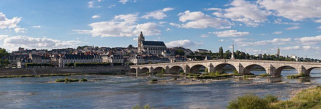
English: A 28 segment (2 x 14) panoramic view of Blois as viewed from the south-east on the far side of the Loire River.
Français : Vue panoramique de Blois (Loir-et-Cher, France), avec notamment le pont Jacques-Gabriel sur la Loire, la cathédrale Saint-Louis, et tout à droite le clocher de la basilique Notre-Dame de la Trinité |
| Datums | |
| Avots | Paša darbs |
| Autors | Diliff |
| Atļauja: (Šī faila izmantošana citur) |
Summary:In using this image or any subsequent derivatives of it, you are required to release the image under the same license. As such, any reproduction of this image, in any medium, must appear with a copy of, or full URL of the license.Attribution of this image to the author (DAVID ILIFF) is also required, preferably in a prominent location near the image.No other conditions may be added to, or removed from this license without the permission of the author and copyright holder.Suggested attribution: "Photo by DAVID ILIFF. License: CC BY-SA 3.0"Please review the full license requirements carefully before using this image. If you would like to clarify the terms of the license or negotiate less restrictive commercial licensing outside of the bounds of GFDL/CC-BY-SA, please contact me by email, or if you don't have a Wikipedia account you can either leave a message on my talk page with your contact details and your request, or you can contact me on Facebook. Please also send a 'friend request' to ensure that I am aware of your message. |
| Camera location | | View this and other nearby images on: OpenStreetMap |
|---|

|
NOTE: This image is a panorama consisting of multiple frames that were merged or stitched in software. As a result, this image necessarily underwent some form of digital manipulation. These manipulations may include blending, blurring, cloning, and colour and perspective adjustments. As a result of these adjustments, the image content may be slightly different from reality at the points where multiple images were combined. This manipulation is often required due to lens, perspective, and parallax distortions.
|
This image has been assessed using the Quality image guidelines and is considered a Quality image.
|
Licence
Es, šī darba autortiesību īpašnieks, publicēju to saskaņā ar šīm licencēm:
Šis fails tiek izplatīts saskaņā ar licences Creative Commons Atsauce-Līdzīgi Noteikumi 3.0 Vispārējiem noteikumiem.
- Jūs varat brīvi:
- koplietot – kopēt, izplatīt un pārraidīt darbu
- remiksēt – pielāgot darbu
- Saskaņā ar šādiem nosacījumiem:
- atsaucoties – Tev ir jānorāda autors, saite uz licenci un to, vai veiktas kādas izmaiņas. To var darīt jebkādā saprātīgā veidā, bet ne tādā, kas norādītu, ka licencētājs atbalsta tevi vai veidu, kā tu izmanto šo darbu.
- nemainot licenci – Ja tu miksē, pārveido vai izmanto materiālu, tev savs devums jāpublicē ar to pašu vai saderīgu licenci kā oriģināls.

|
Ir dota atļauja kopēt, izplatīt un/vai pārveidot šo dokumentu saskaņā ar GNU brīvās dokumentācijas licences, versijas 1.2 vai jebkuras vēlākas versijas, ko publiskojis Brīvās programmatūras fonds nosacījumiem; bez nemainīgajām sadaļā, priekšējā un aizmugurēja'vāka tekstiem. Licences kopija ir iekļauta sadaļā ar nosaukumu GNU brīvās dokumentācijas licence. |
Jūs varat izvēlēties licenci pēc jūsu vēlmes.
Faila hronoloģija
Uzklikšķini uz datums/laiks kolonnā esošās saites, lai apskatītos, kā šis fails izskatījās tad.
| Datums/Laiks | Attēls | Izmēri | Dalībnieks | Komentārs | |
|---|---|---|---|---|---|
| tagadējais | 2011. gada 14. augusts, plkst. 23.31 | 12 000 × 4 105 (14,95 MB) | Gzzz | Deletion of cloned men on the bridge (Modification asked by Tomer T) | |
| 2011. gada 4. augusts, plkst. 14.07 | 12 000 × 4 105 (14,94 MB) | Diliff | {{Information |Description ={{en|1=A 28 segment (2 x 14) panoramic view of Blois as viewed from the south-east on the far side of the Loire River.}} |Source ={{own}} |Author =Diliff |Date =2011-07-10 |Permissio |
Faila lietojums
Šo failu izmanto šajā 1 lapā:
Globālais faila lietojums
Šīs Vikipēdijas izmanto šo failu:
- Izmantojums an.wikipedia.org
- Izmantojums ar.wikipedia.org
- Izmantojums arz.wikipedia.org
- Izmantojums azb.wikipedia.org
- Izmantojums bm.wikipedia.org
- Izmantojums br.wikipedia.org
- Izmantojums cs.wikipedia.org
- Izmantojums de.wikivoyage.org
- Izmantojums el.wikipedia.org
- Izmantojums en.wikipedia.org
- Blois
- Portal:Geography
- Portal:Geography/Featured picture
- User:Diliff
- Wikipedia:Featured pictures/Places/Panorama
- User:Tomer T
- User talk:Tomer T/Archive 1
- Talk:Blois
- Wikipedia:Featured pictures thumbs/28
- Wikipedia:Featured picture candidates/August-2011
- Wikipedia:Featured picture candidates/Blois panorama
- Wikipedia:Wikipedia Signpost/2011-08-29/Featured content
- User talk:Diliff/Archive9
- Wikipedia:Picture of the day/January 2013
- Template:POTD/2013-01-14
- Wikipedia:Main Page history/2013 January 14
- Portal:Geography/Featured picture/23
- User talk:Diliff/Archive10
- Wikipedia:Wikipedia Signpost/Single/2011-08-29
- Jacques-Gabriel Bridge
- Izmantojums eo.wikipedia.org
- Izmantojums es.wikipedia.org
- Izmantojums fa.wikipedia.org
- Izmantojums fi.wikipedia.org
- Izmantojums fr.wikipedia.org
- Izmantojums fr.wikivoyage.org
Skatīt šī faila pilno globālo izmantojumu.