
Attēls:Carte de ukraine 1919.jpg

Šī priekšskata izmērs: 800 × 508 pikseļi. Citi izmēri: 320 × 203 pikseļi | 640 × 406 pikseļi | 934 × 593 pikseļi.
Sākotnējais fails (934 × 593 pikseļi, faila izmērs: 305 KB, MIME tips: image/jpeg)
| Šis fails ir no Vikikrātuves. Tā apraksts no attēla lapas Vikikrātuvē ir parādīts zemāk. Vikikrātuve ir brīvi licencēta failu krātuve. Tu vari tai palīdzēt. |
Kopsavilkums
| Apraksts |
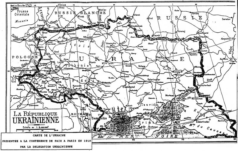
Deutsch: Grenzziehung der Ukrainischen Republik, wie sie von der ukrainischen Delegation auf der Pariser Friedenskonferenz 1919 präsentiert wurde
English: Map of Ukraine presented by Ukrainian delegation on Paris Peace Conference, 1919
Українська: Межі України, які були заявлені делегацією УНР на Паризькій мирній конференції в 1919-20 рр. |
| Datums | 1919 |
| Avots | direct source:Documents of Paris Peace Conference 1919 see also :"Akten zur deutschen auswärtigen Politik 1918-1945" Ser. A, 1918-1925. Bd. 1, 9. November bis 5. Mai 1919 Göttingen : Vandenhoeck und Ruprecht, 1982. |
| Autors | Government of ZUNR in name of ZUNR and UNR, official document of government of Ukraine |
| Citas versijas |
|


Licence
This file is a Ukrainian or Ukrainian SSR work and it is presently in the public domain in Ukraine, because it was published before January 1, 1954, and the creator (if known) died before that date (details).
|
 |
Faila hronoloģija
Uzklikšķini uz datums/laiks kolonnā esošās saites, lai apskatītos, kā šis fails izskatījās tad.
| Datums/Laiks | Attēls | Izmēri | Dalībnieks | Komentārs | |
|---|---|---|---|---|---|
| tagadējais | 2011. gada 2. oktobris, plkst. 03.48 | | 934 × 593 (305 KB) | Yerevanci | better version |
| 2008. gada 8. marts, plkst. 04.49 |  | 934 × 593 (194 KB) | Riwnodennyk | {{Information |Description={{en|Map of Ukraine perposed by Ukrainian delegation on Paris Peace Conference, 1919}} |Source=[http://uk.wikipedia.org/wiki/Зображення:Carte_de_ukraine_1919.jpg Ukrainian Wikipedia] |
Faila lietojums
Šo failu neizmanto nevienā lapā.
Globālais faila lietojums
Šīs Vikipēdijas izmanto šo failu:
- Izmantojums be-tarask.wikipedia.org
- Izmantojums et.wikipedia.org