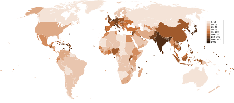
Attēls:Countries by population density.svg

Size of this PNG preview of this SVG file: 800 × 353 pikseļi. Citi izmēri: 320 × 141 pikseļi | 640 × 282 pikseļi | 1 024 × 452 pikseļi | 1 280 × 565 pikseļi | 2 560 × 1 129 pikseļi | 6 000 × 2 647 pikseļi.
Sākotnējais fails (SVG fails, definētais izmērs 6 000 × 2 647 pikseļi, faila izmērs: 1,62 MB)
Faila hronoloģija
Uzklikšķini uz datums/laiks kolonnā esošās saites, lai apskatītos, kā šis fails izskatījās tad.
| Datums/Laiks | Attēls | Izmēri | Dalībnieks | Komentārs | |
|---|---|---|---|---|---|
| tagadējais | 2011. gada 22. decembris, plkst. 02.33 |  | 6 000 × 2 647 (1,62 MB) | Quibik | added transparency |
| 2011. gada 20. februāris, plkst. 16.43 |  | 6 000 × 2 647 (1,62 MB) | Erik del Toro Streb | typographically corrected | |
| 2008. gada 7. janvāris, plkst. 05.22 |  | 6 000 × 2 647 (1,62 MB) | Briefplan~commonswiki | {{Information |Description=A map of the world, with colours to highlight the population density of each country or territory. Numbers on the legend are in people per km<sup>2</sup>, and all countries smaller than 20,000 km<sup>2</sup> are represented by a |
Faila lietojums
Šo failu neizmanto nevienā lapā.
Globālais faila lietojums
Šīs Vikipēdijas izmanto šo failu:
- Izmantojums af.wikipedia.org
- Izmantojums ar.wikipedia.org
- Izmantojums arz.wikipedia.org
- Izmantojums ast.wikipedia.org
- Izmantojums av.wikipedia.org
- Izmantojums awa.wikipedia.org
- Izmantojums azb.wikipedia.org
- Izmantojums az.wikipedia.org
- Izmantojums ba.wikipedia.org
- Izmantojums be.wikipedia.org
- Izmantojums bg.wikipedia.org
- Izmantojums bs.wikipedia.org
- Izmantojums ca.wikipedia.org
- Izmantojums ckb.wikipedia.org
- Izmantojums cs.wikipedia.org
- Izmantojums cy.wikipedia.org
- Izmantojums de.wikipedia.org
- Izmantojums de.wikiversity.org
- Izmantojums diq.wikipedia.org
- Izmantojums dsb.wikipedia.org
- Izmantojums en.wikipedia.org
- Izmantojums eo.wikipedia.org
- Izmantojums es.wikipedia.org
- Izmantojums eu.wikipedia.org
- Izmantojums fi.wikipedia.org
- Izmantojums fr.wikipedia.org
Skatīt šī faila pilno globālo izmantojumu.
