
Attēls:Dardanelles map2.png
Augstāka izšķirtspēja nav pieejama.
Dardanelles_map2.png (700 × 600 pikseļi, faila izmērs: 123 KB, MIME tips: image/png)
| Šis fails ir no Vikikrātuves. Tā apraksts no attēla lapas Vikikrātuvē ir parādīts zemāk. Vikikrātuve ir brīvi licencēta failu krātuve. Tu vari tai palīdzēt. |

|
This map image could be re-created using vector graphics as an SVG file. This has several advantages; see Commons:Media for cleanup for more information. If an SVG form of this image is available, please upload it and afterwards replace this template with
{{vector version available|new image name}}.
It is recommended to name the SVG file “Dardanelles map2.svg”—then the template Vector version available (or Vva) does not need the new image name parameter. |
Kopsavilkums
Español: Estrecho de los Dardanelos
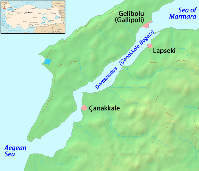
Map of the Dardanelles. Modified version of Image:Dardanelles map.png
Image history of en:Image:Dardanelles map2.png:
(del) (cur) 23:48, 25 September 2005 . . ChrisO . . 700x600 (125686 bytes) (Amended version of :Image:Dardanelles map.png {{PD}})
| |
This work has been released into the public domain by its author, ChrisO, at the angļu Vikipēdija project. This applies worldwide. In case this is not legally possible: |
Faila hronoloģija
Uzklikšķini uz datums/laiks kolonnā esošās saites, lai apskatītos, kā šis fails izskatījās tad.
| Datums/Laiks | Attēls | Izmēri | Dalībnieks | Komentārs | |
|---|---|---|---|---|---|
| tagadējais | 2005. gada 13. oktobris, plkst. 20.26 | | 700 × 600 (123 KB) | ChongDae | This image was copied from wikipedia:en. The original description was: Amended version of Image:Dardanelles map.png {{PD}} {| border="1" ! date/time || username || edit summary |---- | 23:48, 25 September 2005 || ChrisO || <nowiki>(Amended version |
Faila lietojums
Šo failu izmanto šajā 1 lapā:
Globālais faila lietojums
Šīs Vikipēdijas izmanto šo failu:
- Izmantojums an.wikipedia.org
- Izmantojums ar.wikipedia.org
- Izmantojums azb.wikipedia.org
- Izmantojums az.wikipedia.org
- Izmantojums be-tarask.wikipedia.org
- Izmantojums be.wikipedia.org
- Izmantojums bg.wikipedia.org
- Izmantojums bn.wikipedia.org
- Izmantojums br.wikipedia.org
- Izmantojums bs.wikipedia.org
- Izmantojums ca.wikipedia.org
- Izmantojums cs.wikipedia.org
- Izmantojums cy.wikipedia.org
- Izmantojums da.wikipedia.org
- Izmantojums de.wikipedia.org
- Izmantojums el.wikipedia.org
- Izmantojums en.wikipedia.org
- Izmantojums eo.wikipedia.org
- Izmantojums fa.wikipedia.org
- Izmantojums fi.wikipedia.org
- Izmantojums frr.wikipedia.org
Skatīt šī faila pilno globālo izmantojumu.