
Attēls:Dione PIA08413.jpg

Sākotnējais fails (6 204 × 3 522 pikseļi, faila izmērs: 2,97 MB, MIME tips: image/jpeg)
| Šis fails ir no Vikikrātuves. Tā apraksts no attēla lapas Vikikrātuvē ir parādīts zemāk. Vikikrātuve ir brīvi licencēta failu krātuve. Tu vari tai palīdzēt. |
Kopsavilkums
| Apraksts |
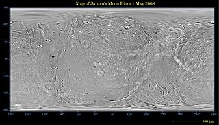
English: This global map of Saturn's moon Dione was created using images taken during Cassini spacecraft flybys, with Voyager images filling in the gaps in Cassini's coverage.
An extensive system of bright ice cliffs created by tectonic fractures adorns the moon's trailing hemisphere. The map is a simple cylindrical (equidistant) projection and has a scale of 614 meters (2,014 feet) per pixel at the equator. The mean radius of Dione used for projection of this map is 562 kilometers (349 miles). This updated map has been shifted west by 0.6 degrees of longitude, compared to the previously released Cassini product (PIA08341), in order to conform to the International Astronomical Union longitude system convention for Dione. The Cassini-Huygens mission is a cooperative project of NASA, the European Space Agency and the Italian Space Agency. The Jet Propulsion Laboratory, a division of the California Institute of Technology in Pasadena, manages the mission for NASA's Science Mission Directorate, Washington, D.C. The Cassini orbiter and its two onboard cameras were designed, developed and assembled at JPL. The imaging operations center is based at the Space Science Institute in Boulder, Colo. |
| Datums | |
| Avots | http://photojournal.jpl.nasa.gov/catalog/PIA08413 |
| Autors | NASA/JPL/Space Science Institute |
| Citas versijas | Derivative works of this file: Dione PIA08413 moon only.JPG |
Licence
| This file is in the public domain in the United States because it was solely created by NASA. NASA copyright policy states that "NASA material is not protected by copyright unless noted". (See Template:PD-USGov, NASA copyright policy page or JPL Image Use Policy.) | ||
 |
Warnings:
|
Faila hronoloģija
Uzklikšķini uz datums/laiks kolonnā esošās saites, lai apskatītos, kā šis fails izskatījās tad.
| Datums/Laiks | Attēls | Izmēri | Dalībnieks | Komentārs | |
|---|---|---|---|---|---|
| tagadējais | 2008. gada 21. maijs, plkst. 01.48 | | 6 204 × 3 522 (2,97 MB) | Bryan Derksen | {{Information |Description={{en|This global map of Saturn's moon Dione was created using images taken during Cassini spacecraft flybys, with Voyager images filling in the gaps in Cassini's coverage. An extensive system of bright ice cliffs created by tec |
Faila lietojums
Šo failu izmanto šajā 1 lapā:
Globālais faila lietojums
Šīs Vikipēdijas izmanto šo failu:
- Izmantojums ca.wikipedia.org
- Izmantojums eo.wikipedia.org
- Izmantojums pl.wikipedia.org