
Attēls:EmpireFrench.png

Šī priekšskata izmērs: 800 × 407 pikseļi. Citi izmēri: 320 × 163 pikseļi | 640 × 325 pikseļi | 1 024 × 521 pikseļi | 1 280 × 651 pikseļi | 2 753 × 1 400 pikseļi.
Sākotnējais fails (2 753 × 1 400 pikseļi, faila izmērs: 193 KB, MIME tips: image/png)
| Šis fails ir no Vikikrātuves. Tā apraksts no attēla lapas Vikikrātuvē ir parādīts zemāk. Vikikrātuve ir brīvi licencēta failu krātuve. Tu vari tai palīdzēt. |


|
This historical map image could be re-created using vector graphics as an SVG file. This has several advantages; see Commons:Media for cleanup for more information. If an SVG form of this image is available, please upload it and afterwards replace this template with
{{vector version available|new image name}}.
It is recommended to name the SVG file “EmpireFrench.svg”—then the template Vector version available (or Vva) does not need the new image name parameter. |
Kopsavilkums
| Apraksts |
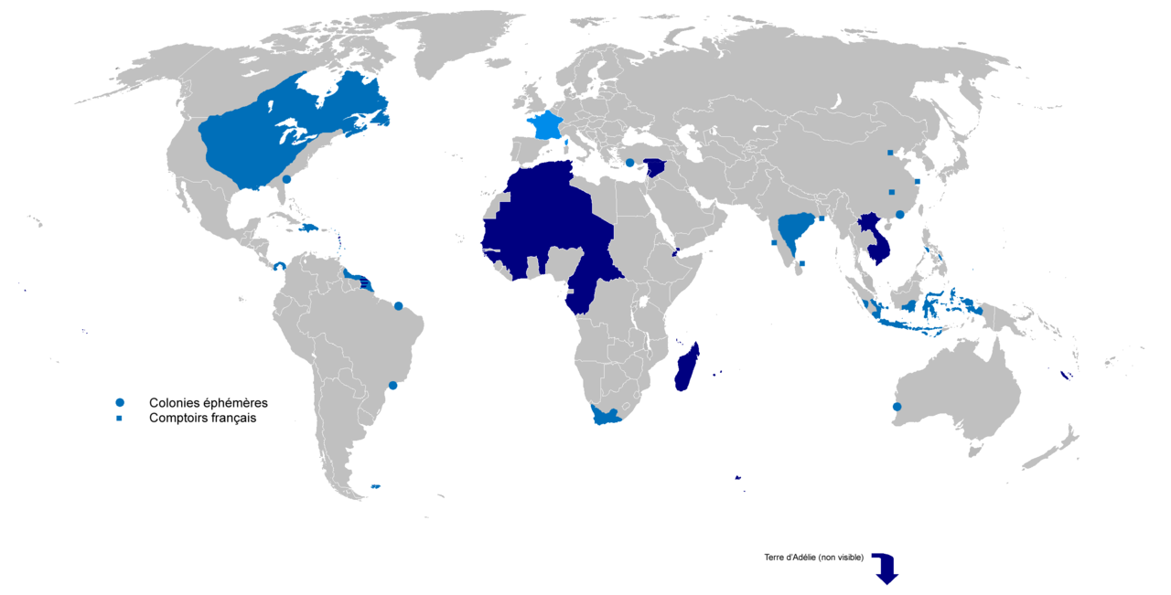
English: Colonial empire from 1542 to 1980
Dark Blue: Second colonial empire Light Blue: First colonial empire |
| Datums | 01/06/2010 |
| Avots | Paša darbs |
| Autors | Gd21091993 |
Licence
| I, the copyright holder of this work, release this work into the public domain. This applies worldwide. In some countries this may not be legally possible; if so: I grant anyone the right to use this work for any purpose, without any conditions, unless such conditions are required by law. |
Faila hronoloģija
Uzklikšķini uz datums/laiks kolonnā esošās saites, lai apskatītos, kā šis fails izskatījās tad.
| Datums/Laiks | Attēls | Izmēri | Dalībnieks | Komentārs | |
|---|---|---|---|---|---|
| tagadējais | 2022. gada 4. aprīlis, plkst. 20.02 | | 2 753 × 1 400 (193 KB) | Oort kuipert | added territory in india and america, source : https://commons.wikimedia.org/wiki/File:New_France_(orthographic_projection).svg https://commons.wikimedia.org/wiki/File:French_possessions_in_the_Americas_(1534-1803).png https://commons.wikimedia.org/wiki/File:Evolution_empire.png |
| 2022. gada 30. marts, plkst. 18.41 |  | 2 753 × 1 400 (194 KB) | Oort kuipert | added colonies under Napoléon I according to https://upload.wikimedia.org/wikipedia/commons/3/33/French_Empire_on_World_1812.png | |
| 2017. gada 8. oktobris, plkst. 15.01 |  | 2 753 × 1 400 (116 KB) | SUM1 | Fixes: unshaded Spanish Morocco (Cape Juby), Equatorial Guinea, Nigeria, Southern Cameroons, Zanzibar, Czech border | |
| 2016. gada 2. marts, plkst. 16.46 |  | 2 753 × 1 400 (99 KB) | Frans45 | in New Caledonia archipelago only the big island was marked, I added : îles Loayutés, île de Pins, îles Chesterfield | |
| 2010. gada 1. jūnijs, plkst. 18.29 |  | 2 753 × 1 400 (316 KB) | Gd21091993 | {{Information |Description={{fr|1=Carte de l'Empire Colonial Français de 1542 à 1980 }} |Source={{own}} |Author=Gd21091993 |Date=01/06/2010 |Permission= |other_versions= }} |
Faila lietojums
Šo failu izmanto šajā 1 lapā:
Globālais faila lietojums
Šīs Vikipēdijas izmanto šo failu:
- Izmantojums ar.wikipedia.org
- Izmantojums ast.wikipedia.org
- Izmantojums azb.wikipedia.org
- Izmantojums bg.wikipedia.org
- Izmantojums br.wikipedia.org
- Izmantojums ca.wikipedia.org
- Izmantojums cs.wikipedia.org
- Izmantojums el.wikipedia.org
- Izmantojums en.wikipedia.org
- Empire
- User:Dimadick
- Kingdom of France
- French colonial flags
- Analysis of Western European colonialism and colonization
- Evolution of the French Empire
- Political history of the world
- User:Jethwarp
- Timeline of European imperialism
- List of modern great powers
- User:Jethwarp/UBX/French Colonial empire
- Category:Wikipedians interested in European colonial empires
- Liberation of France
- Honor killings by region
- Izmantojums en.wikibooks.org
- Izmantojums en.wikiquote.org
- Izmantojums en.wiktionary.org
- Izmantojums eo.wikipedia.org
- Izmantojums es.wikipedia.org
- Izmantojums eu.wikipedia.org
- Izmantojums fa.wikipedia.org
- Izmantojums fi.wikipedia.org
- Izmantojums fr.wikipedia.org
- Izmantojums fr.wiktionary.org
- Izmantojums gl.wikipedia.org
Skatīt šī faila pilno globālo izmantojumu.