
Attēls:Ennstal.jpg

Šī priekšskata izmērs: 448 × 600 pikseļi. Citi izmēri: 179 × 240 pikseļi | 358 × 480 pikseļi | 573 × 768 pikseļi | 1 120 × 1 500 pikseļi.
Sākotnējais fails (1 120 × 1 500 pikseļi, faila izmērs: 260 KB, MIME tips: image/jpeg)
| Šis fails ir no Vikikrātuves. Tā apraksts no attēla lapas Vikikrātuvē ir parādīts zemāk. Vikikrātuve ir brīvi licencēta failu krātuve. Tu vari tai palīdzēt. |
Kopsavilkums
| Apraksts |
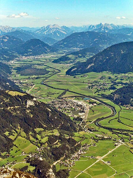
Deutsch: Oberes Ennstal zwischen Stainach und Liezen in der Steiermark, vom Grimming aus gesehen, Blickrichtung Osten, gegen das Gesäuse:
English: Valley of the Enns River (“Ennstal”), between the towns of Stainach (below centre) and Liezen (farther back, upper third), seen from the summit of Mt. Grimming, viewing direction is to the east. In the background the tops of the two rocky (limestone) ridges flanking the Gesäuse canyon, cut by the Enns River further downstream, are visible. |
| Datums | |
| Avots | Own photo, slightly manipulated to reduce haze |
| Autors | User:Stemonitis |
| Atļauja: (Šī faila izmantošana citur) |
CC Attribution ShareAlike 2.5 |
| Camera location | | View this and other nearby images on: OpenStreetMap |
|---|
Licence
Šis fails tiek izplatīts saskaņā ar licences Creative Commons Atsauce-Līdzīgi Noteikumi 2.5 Vispārējiem noteikumiem.
- Jūs varat brīvi:
- koplietot – kopēt, izplatīt un pārraidīt darbu
- remiksēt – pielāgot darbu
- Saskaņā ar šādiem nosacījumiem:
- atsaucoties – Tev ir jānorāda autors, saite uz licenci un to, vai veiktas kādas izmaiņas. To var darīt jebkādā saprātīgā veidā, bet ne tādā, kas norādītu, ka licencētājs atbalsta tevi vai veidu, kā tu izmanto šo darbu.
- nemainot licenci – Ja tu miksē, pārveido vai izmanto materiālu, tev savs devums jāpublicē ar to pašu vai saderīgu licenci kā oriģināls.
| Annotations | This image is annotated: View the annotations at Commons |
Faila hronoloģija
Uzklikšķini uz datums/laiks kolonnā esošās saites, lai apskatītos, kā šis fails izskatījās tad.
| Datums/Laiks | Attēls | Izmēri | Dalībnieks | Komentārs | |
|---|---|---|---|---|---|
| tagadējais | 2023. gada 23. novembris, plkst. 14.57 | | 1 120 × 1 500 (260 KB) | Martin Geisler | heller, Dunstentfernung |
| 2006. gada 4. septembris, plkst. 17.07 |  | 1 120 × 1 500 (160 KB) | Stemonitis | {{Information |Description=Ennstal, between Stainach (below centre) and Liezen (towards the background), seen from the summit of Grimming. On the horizon, the two ridges of the Gesäuse can be seen, one on either side of the River Enns. |Source=Own photo, |
Faila lietojums
Šo failu izmanto šajā 1 lapā:
Globālais faila lietojums
Šīs Vikipēdijas izmanto šo failu:
- Izmantojums ar.wikipedia.org
- Izmantojums arz.wikipedia.org
- Izmantojums azb.wikipedia.org
- Izmantojums ba.wikipedia.org
- Izmantojums be.wikipedia.org
- Izmantojums bg.wikipedia.org
- Izmantojums bn.wikipedia.org
- Izmantojums ca.wikipedia.org
- Izmantojums ceb.wikipedia.org
- Izmantojums cs.wikipedia.org
- Izmantojums cv.wikipedia.org
- Izmantojums da.wikipedia.org
- Izmantojums de.wikipedia.org
- Izmantojums el.wikipedia.org
- Izmantojums en.wikipedia.org
- Izmantojums eo.wikipedia.org
- Izmantojums es.wikipedia.org
- Izmantojums et.wikipedia.org
- Izmantojums eu.wikipedia.org
- Izmantojums fa.wikipedia.org
- Izmantojums fi.wikipedia.org
- Izmantojums fr.wikipedia.org
- Izmantojums hu.wikipedia.org
- Izmantojums hy.wikipedia.org
- Izmantojums id.wikipedia.org
- Izmantojums it.wikipedia.org
- Izmantojums ka.wikipedia.org
- Izmantojums ko.wikipedia.org
- Izmantojums ku.wikipedia.org
- Izmantojums lld.wikipedia.org
- Izmantojums lt.wikipedia.org
- Izmantojums nl.wikipedia.org
- Izmantojums nn.wikipedia.org
- Izmantojums no.wikipedia.org
- Izmantojums pl.wikipedia.org
- Izmantojums pt.wikipedia.org
- Izmantojums ro.wikipedia.org
- Izmantojums ru.wikipedia.org
- Izmantojums sk.wikipedia.org
- Izmantojums sl.wikipedia.org
Skatīt šī faila pilno globālo izmantojumu.