
Attēls:Equatorial Guinea, administrative divisions - de - colored 2020.svg

Sākotnējais fails (SVG fails, definētais izmērs 1 091 × 1 042 pikseļi, faila izmērs: 194 KB)
| Šis fails ir no Vikikrātuves. Tā apraksts no attēla lapas Vikikrātuvē ir parādīts zemāk. Vikikrātuve ir brīvi licencēta failu krātuve. Tu vari tai palīdzēt. |
Kopsavilkums


.svg)


_(Paris_zoom).svg)
.svg)
,_administrative_divisions_-_de_-_colored_(multizoom).svg)
_-_colored.svg)
.svg)
,_administrative_divisions_-_Nmbrs_(multizoom).svg)
,_administrative_divisions_-_de_-_colored.svg)
_-_de_-_colored.svg)

.svg)

.svg)
Licence
Usage of this file with:

explanatory notes: Legally binding is only the full legalcode. For a free usage I recommend to respect the following licence conditions:
1. Provide my name as given above: NordNordWest,
2. a copy of, or the URI for, the applicable license: https://creativecommons.org/licenses/by-sa/3.0/de/legalcode,
3. the title of the work,
4. in the case of an adaptation, a credit identifying the use of the work in the adaptation.
This license and the rights granted hereunder will terminate automatically upon any breach by you of the terms of this license. Any of the above conditions can be waived if you get permission from the copyright holder. If you have questions or wish differing conditions, please contact me through nnwest or my discussion page ![]() t-online.de
t-online.de
- Jūs varat brīvi:
- koplietot – kopēt, izplatīt un pārraidīt darbu
- remiksēt – pielāgot darbu
- Saskaņā ar šādiem nosacījumiem:
- atsaucoties – Tev ir jānorāda autors, saite uz licenci un to, vai veiktas kādas izmaiņas. To var darīt jebkādā saprātīgā veidā, bet ne tādā, kas norādītu, ka licencētājs atbalsta tevi vai veidu, kā tu izmanto šo darbu.
- nemainot licenci – Ja tu miksē, pārveido vai izmanto materiālu, tev savs devums jāpublicē ar to pašu vai saderīgu licenci kā oriģināls.

Faila hronoloģija
Uzklikšķini uz datums/laiks kolonnā esošās saites, lai apskatītos, kā šis fails izskatījās tad.
| Datums/Laiks | Attēls | Izmēri | Dalībnieks | Komentārs | |
|---|---|---|---|---|---|
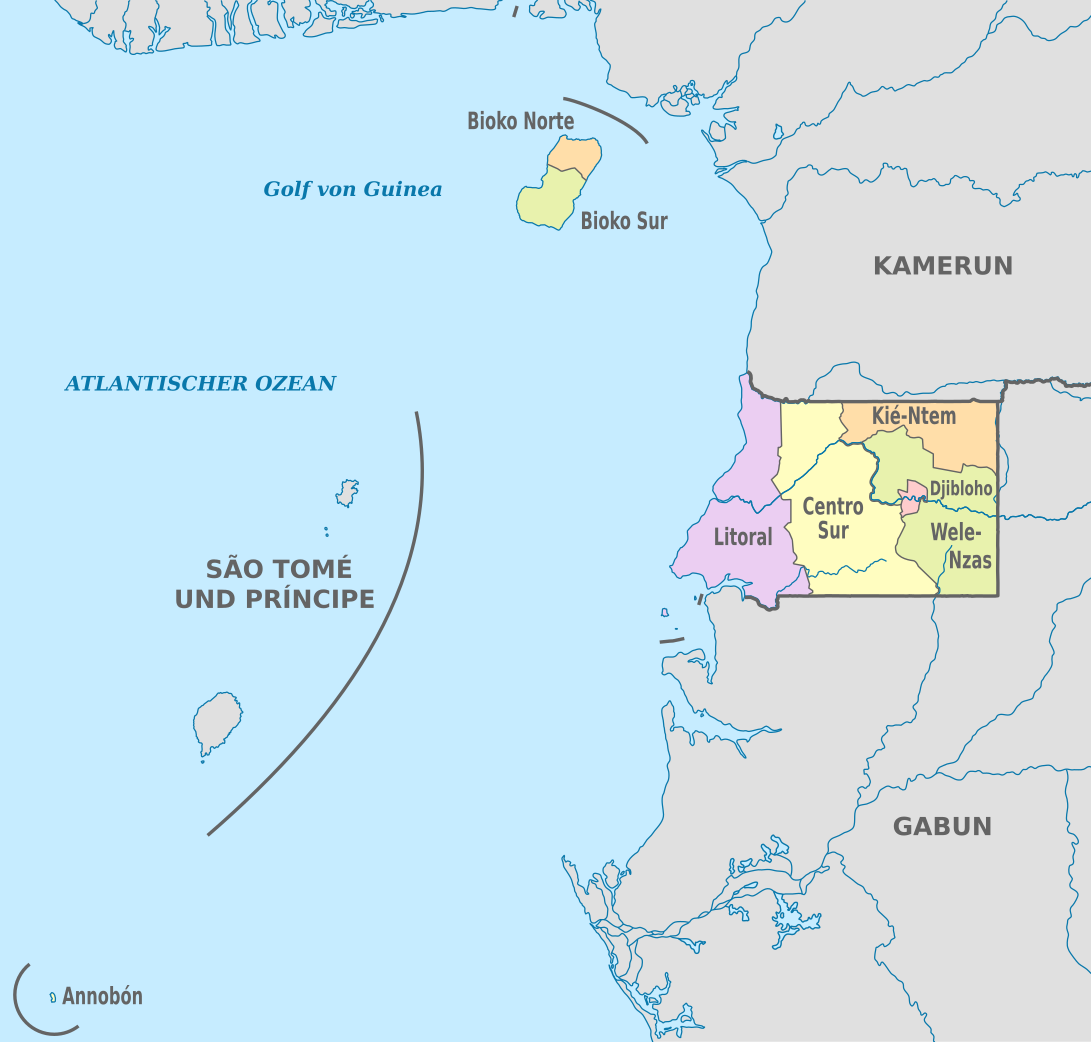
| tagadējais | 2020. gada 25. novembris, plkst. 22.53 | | 1 091 × 1 042 (194 KB) | NordNordWest | == {{int:filedesc}} == {{Information |Description={{de|Karte der politischen Gliederung von Äquatorialguinea, Stand 2020}} {{en|Map of the administrative divisions of Equatorial Guinee}} |Source={{own}} |date=2020-11-25 |author={{U|NordNordWest}} |permission= |other_versions={{SVG labeled maps of administrative divisions (location map scheme)}} }} == {{int:license-header}} == {{User:NordNordWest/LicenceMap}} [[Category:SVG labeled maps of administrative divisions of Equatorial Guinea (locat... |
Faila lietojums
Šo failu izmanto šajā 1 lapā:
Globālais faila lietojums
Šīs Vikipēdijas izmanto šo failu:
- Izmantojums ab.wikipedia.org
- Izmantojums ca.wikipedia.org
- Izmantojums cs.wikipedia.org
- Izmantojums de.wikipedia.org
- Izmantojums en.wikipedia.org
- Izmantojums eo.wikipedia.org
- Izmantojums fi.wikipedia.org
- Izmantojums frr.wikipedia.org
- Izmantojums gl.wikipedia.org
- Izmantojums id.wikipedia.org
- Izmantojums is.wikipedia.org
- Izmantojums it.wikipedia.org
- Izmantojums ja.wikipedia.org
- Izmantojums nl.wikipedia.org
- Izmantojums ru.wikipedia.org
- Izmantojums tr.wikipedia.org
- Izmantojums zh.wikipedia.org