
Attēls:Europe 1740 en.png

Šī priekšskata izmērs: 800 × 570 pikseļi. Citi izmēri: 320 × 228 pikseļi | 640 × 456 pikseļi | 1 024 × 730 pikseļi | 1 280 × 913 pikseļi | 2 560 × 1 825 pikseļi | 3 872 × 2 761 pikseļi.
Sākotnējais fails (3 872 × 2 761 pikseļi, faila izmērs: 1,25 MB, MIME tips: image/png)
| Šis fails ir no Vikikrātuves. Tā apraksts no attēla lapas Vikikrātuvē ir parādīts zemāk. Vikikrātuve ir brīvi licencēta failu krātuve. Tu vari tai palīdzēt. |
_en.png)
.png)
.jpg)
Kopsavilkums
| Apraksts |
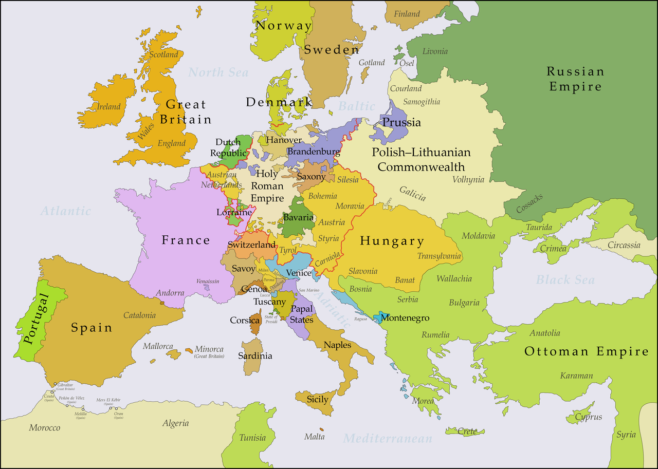
English: This map shows Europe in the years between the 1739 Treaty of Belgrade (the end of the Austro–Turkish War (1737–39)) and the beginning of the War of the Austrian Succession in 1740. The red line marks the borders of the Holy Roman Empire. The work was created with Inkscape and is mainly based on a map in: Putzger - Historischer Weltatlas, Berlin 1990, 78 pp. |
| Datums | |
| Avots | Paša darbs, based on File:Europe 1748-1766 en.png |
| Autors | Bryan Rutherford |
Licence
Es, šī darba autortiesību īpašnieks, publicēju to saskaņā ar šo licenci:
This file is licensed under the Creative Commons Attribution-Share Alike 4.0 International license.
- Jūs varat brīvi:
- koplietot – kopēt, izplatīt un pārraidīt darbu
- remiksēt – pielāgot darbu
- Saskaņā ar šādiem nosacījumiem:
- atsaucoties – Tev ir jānorāda autors, saite uz licenci un to, vai veiktas kādas izmaiņas. To var darīt jebkādā saprātīgā veidā, bet ne tādā, kas norādītu, ka licencētājs atbalsta tevi vai veidu, kā tu izmanto šo darbu.
- nemainot licenci – Ja tu miksē, pārveido vai izmanto materiālu, tev savs devums jāpublicē ar to pašu vai saderīgu licenci kā oriģināls.
Faila hronoloģija
Uzklikšķini uz datums/laiks kolonnā esošās saites, lai apskatītos, kā šis fails izskatījās tad.
| Datums/Laiks | Attēls | Izmēri | Dalībnieks | Komentārs | |
|---|---|---|---|---|---|
| tagadējais | 2018. gada 16. jūlijs, plkst. 00.49 | | 3 872 × 2 761 (1,25 MB) | Bryanrutherford0 | Added the Ionian Islands, made the Duchy of Milan a Habsburg possession |
| 2018. gada 10. jūlijs, plkst. 05.28 |  | 3 872 × 2 761 (1,25 MB) | Bryanrutherford0 | Added Comtat Venaissin and redrew borders of Neuchâtel, Bishopric Basel, and Montbéliard | |
| 2017. gada 3. oktobris, plkst. 03.39 |  | 3 872 × 2 761 (1,25 MB) | Bryanrutherford0 | Transferred control of Saaremaa and Hiiumaa to Russia (1721 Treaty of Nystad) | |
| 2017. gada 24. augusts, plkst. 15.50 |  | 3 872 × 2 761 (1,25 MB) | Bryanrutherford0 | Removed Prussian East Frisia (acquired 1744) | |
| 2017. gada 23. augusts, plkst. 23.17 |  | 3 872 × 2 761 (1,25 MB) | Bryanrutherford0 | User created page with UploadWizard |
Faila lietojums
Šo failu izmanto šajās 3 lapās:
Globālais faila lietojums
Šīs Vikipēdijas izmanto šo failu:
- Izmantojums azb.wikipedia.org
- Izmantojums bg.wikipedia.org
- Izmantojums ca.wikipedia.org
- Izmantojums cs.wikipedia.org
- Izmantojums de.wikipedia.org
- Izmantojums el.wikipedia.org
- Izmantojums en.wikipedia.org
- Izmantojums es.wikipedia.org
- Izmantojums fa.wikipedia.org
- Izmantojums fi.wikipedia.org
- Izmantojums fr.wikipedia.org
- Izmantojums gcr.wikipedia.org
- Izmantojums he.wikipedia.org
- Izmantojums id.wikipedia.org
- Izmantojums it.wikipedia.org
- Izmantojums ja.wikipedia.org
- Izmantojums pt.wikipedia.org
- Izmantojums ru.wikipedia.org
- Izmantojums sr.wikipedia.org
- Izmantojums zh.wikipedia.org