
Attēls:Flores map.png
Augstāka izšķirtspēja nav pieejama.
Flores_map.png (300 × 122 pikseļi, faila izmērs: 21 KB, MIME tips: image/png)
| Šis fails ir no Vikikrātuves. Tā apraksts no attēla lapas Vikikrātuvē ir parādīts zemāk. Vikikrātuve ir brīvi licencēta failu krātuve. Tu vari tai palīdzēt. |

|
This locator map image could be re-created using vector graphics as an SVG file. This has several advantages; see Commons:Media for cleanup for more information. If an SVG form of this image is available, please upload it and afterwards replace this template with
{{vector version available|new image name}}.
It is recommended to name the SVG file “Flores map.svg”—then the template Vector version available (or Vva) does not need the new image name parameter. |
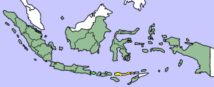
This image was copied from wikipedia:en. The original description was:
Map showing Flores Island within Indonesia
| I, the copyright holder of this work, release this work into the public domain. This applies worldwide. In some countries this may not be legally possible; if so: I grant anyone the right to use this work for any purpose, without any conditions, unless such conditions are required by law. |
| date/time | username | edit summary |
|---|---|---|
| 14:17, 14 March 2005 | *drew | (Map showing Flores Island within Indonesia) |
Faila hronoloģija
Uzklikšķini uz datums/laiks kolonnā esošās saites, lai apskatītos, kā šis fails izskatījās tad.
| Datums/Laiks | Attēls | Izmēri | Dalībnieks | Komentārs | |
|---|---|---|---|---|---|
| tagadējais | 2007. gada 2. februāris, plkst. 13.19 | 300 × 122 (21 KB) | J. Patrick Fischer | The original image was copied from wikipedia:en. The image was corrected by user:J. Patrick Fischer (two islands east of Flores were wrong marked as part of Flores before). The original description was: Map showing Flores Island within Indonesia {{ | |
| 2006. gada 10. oktobris, plkst. 15.26 | 300 × 122 (16 KB) | UtherSRG | Change color. | ||
| 2005. gada 5. oktobris, plkst. 15.27 | 300 × 122 (15 KB) | ChongDae | This image was copied from wikipedia:en. The original description was: Map showing Flores Island within Indonesia {{PD}} {| border="1" ! date/time || username || edit summary |---- | 14:17, 14 March 2005 || *drew || <nowiki>(Map showing Flores Island wi |
Faila lietojums
Šo failu neizmanto nevienā lapā.
Globālais faila lietojums
Šīs Vikipēdijas izmanto šo failu:
- Izmantojums az.wikipedia.org
- Izmantojums cy.wikipedia.org
- Izmantojums el.wikipedia.org
- Izmantojums en.wikipedia.org
- Izmantojums en.wikivoyage.org
- Izmantojums en.wiktionary.org
- Izmantojums eo.wikipedia.org
- Izmantojums fi.wikipedia.org
- Izmantojums fr.wikipedia.org
- Izmantojums gl.wikipedia.org
- Izmantojums he.wikipedia.org
- Izmantojums id.wikipedia.org
- Izmantojums ilo.wikipedia.org
- Izmantojums it.wikipedia.org
- Izmantojums ko.wikipedia.org
- Izmantojums min.wikipedia.org
- Izmantojums ml.wikipedia.org
- Izmantojums nl.wikipedia.org
- Izmantojums nn.wikipedia.org
- Izmantojums pt.wikipedia.org
- Izmantojums tr.wikipedia.org
- Izmantojums zh.wikipedia.org