
Attēls:Gunung Klabat.jpg
Augstāka izšķirtspēja nav pieejama.
Gunung_Klabat.jpg (640 × 428 pikseļi, faila izmērs: 52 KB, MIME tips: image/jpeg)
| Šis fails ir no Vikikrātuves. Tā apraksts no attēla lapas Vikikrātuvē ir parādīts zemāk. Vikikrātuve ir brīvi licencēta failu krātuve. Tu vari tai palīdzēt. |
| Apraksts |
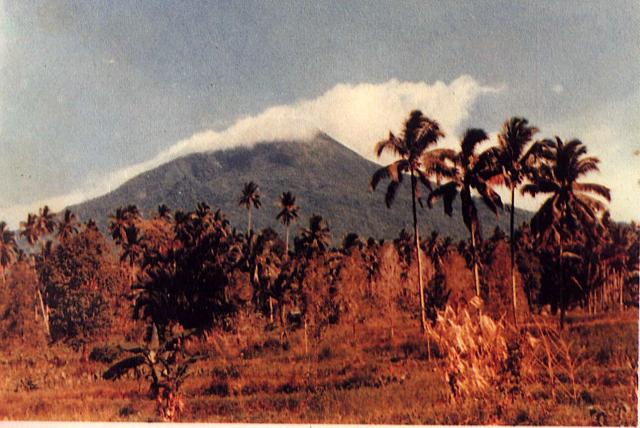
English: Weather clouds drape the summit of Gunung Klabat, an isolated symmetrical stratovolcano that rises to 1995 m near the eastern tip of the northern arm of Sulawesi. Klabat, rising above the farming village of Tatelu below its NW flank, has a shallow lake in its 170 x 250 m summit crater. No verified historical eruptions have occurred from Klabat volcano, the highest peak in northern Sulawesi. |
|||
| Datums | ||||
| Avots | http://www.volcano.si.edu/world/volcano.cfm?vnum=0606-12=&volpage=photos&photo=063054 | |||
| Autors | S. Wikartadipura (Volcanological Survey of Indonesia) | |||
| Atļauja: (Šī faila izmantošana citur) |
|

Faila hronoloģija
Uzklikšķini uz datums/laiks kolonnā esošās saites, lai apskatītos, kā šis fails izskatījās tad.
| Datums/Laiks | Attēls | Izmēri | Dalībnieks | Komentārs | |
|---|---|---|---|---|---|
| tagadējais | 2010. gada 26. jūlijs, plkst. 20.07 | | 640 × 428 (52 KB) | Michael Metzger | {{Information |Description={{en|1=Weather clouds drape the summit of Gunung Klabat, an isolated symmetrical stratovolcano that rises to 1995 m near the eastern tip of the northern arm of Sulawesi. Klabat, rising above the farming village of Tatelu below i |
Faila lietojums
Šo failu izmanto šajā 1 lapā:
Globālais faila lietojums
Šīs Vikipēdijas izmanto šo failu:
- Izmantojums ca.wikipedia.org
- Izmantojums cs.wikipedia.org
- Izmantojums de.wikipedia.org
- Izmantojums en.wikipedia.org
- Izmantojums es.wikipedia.org
- Izmantojums eu.wikipedia.org
- Izmantojums fr.wikipedia.org
- Izmantojums id.wikipedia.org
- Izmantojums ja.wikipedia.org
- Izmantojums jv.wikipedia.org
- Izmantojums ko.wikipedia.org
- Izmantojums ms.wikipedia.org
- Izmantojums pl.wikipedia.org
- Izmantojums pt.wikipedia.org
- Izmantojums sk.wikipedia.org
- Izmantojums uk.wikipedia.org
- Izmantojums www.wikidata.org
- Izmantojums zh.wikipedia.org