
Attēls:Hawaii Island topographic map-fr.svg

Size of this PNG preview of this SVG file: 728 × 600 pikseļi. Citi izmēri: 291 × 240 pikseļi | 583 × 480 pikseļi | 932 × 768 pikseļi | 1 243 × 1 024 pikseļi | 2 485 × 2 048 pikseļi | 3 110 × 2 563 pikseļi.
Sākotnējais fails (SVG fails, definētais izmērs 3 110 × 2 563 pikseļi, faila izmērs: 2,11 MB)
| Šis fails ir no Vikikrātuves. Tā apraksts no attēla lapas Vikikrātuvē ir parādīts zemāk. Vikikrātuve ir brīvi licencēta failu krātuve. Tu vari tai palīdzēt. |
Kopsavilkums
| Apraksts | |||||||||
| Datums | |||||||||
| Avots |
Français : Travail personnel.
Sources :
Logiciels utilisés :
Autres données :
English: Personal work.
Sources:
Software used:
Other Details:
|
||||||||
| Izveidotājs | |||||||||
| Georeferencing | If inappropriate please set warp_status = skip to hide. | ||||||||
| Citas versijas | |||||||||
| Atsauce (required by the license) | © Sémhur / Wikimedia Commons / | ||||||||
| Assessments |
|
||||||||
| SVG | W3C-validity not checked.
|
||||||||
| Graphic Lab |


| Camera location | | View this and other nearby images on: OpenStreetMap |
|---|
Licence
Es, šī darba autortiesību īpašnieks, publicēju to saskaņā ar šīm licencēm:
| Copyleft: This work of art is free; you can redistribute it and/or modify it according to terms of the Free Art License. You will find a specimen of this license on the Copyleft Attitude site as well as on other sites. |
This file is licensed under the Creative Commons Attribution-Share Alike 4.0 International, 3.0 Unported, 2.5 Generic, 2.0 Generic and 1.0 Generic license.
- Jūs varat brīvi:
- koplietot – kopēt, izplatīt un pārraidīt darbu
- remiksēt – pielāgot darbu
- Saskaņā ar šādiem nosacījumiem:
- atsaucoties – Tev ir jānorāda autors, saite uz licenci un to, vai veiktas kādas izmaiņas. To var darīt jebkādā saprātīgā veidā, bet ne tādā, kas norādītu, ka licencētājs atbalsta tevi vai veidu, kā tu izmanto šo darbu.
- nemainot licenci – Ja tu miksē, pārveido vai izmanto materiālu, tev savs devums jāpublicē ar to pašu vai saderīgu licenci kā oriģināls.
Jūs varat izvēlēties licenci pēc jūsu vēlmes.
Faila hronoloģija
Uzklikšķini uz datums/laiks kolonnā esošās saites, lai apskatītos, kā šis fails izskatījās tad.
| Datums/Laiks | Attēls | Izmēri | Dalībnieks | Komentārs | |
|---|---|---|---|---|---|
| tagadējais | 2009. gada 16. februāris, plkst. 15.24 | | 3 110 × 2 563 (2,11 MB) | Sémhur | Valid SVG |
| 2008. gada 7. maijs, plkst. 20.31 |  | 3 110 × 2 563 (2,19 MB) | Sémhur | Route coupée trop courte, je rallonge. | |
| 2008. gada 2. maijs, plkst. 20.57 |  | 3 110 × 2 563 (2,18 MB) | Sémhur | Suppression d'une partie d'une route détruite par une coulée de lave | |
| 2008. gada 1. maijs, plkst. 13.37 |  | 3 110 × 2 563 (2,18 MB) | Sémhur | New version, with vectorized shaded relief | |
| 2008. gada 29. aprīlis, plkst. 21.35 |  | 3 110 × 2 563 (1 017 KB) | Sting | Slight correction | |
| 2008. gada 29. aprīlis, plkst. 21.11 |  | 3 110 × 2 563 (1 017 KB) | Sting | Added legend | |
| 2008. gada 22. aprīlis, plkst. 19.01 |  | 3 110 × 2 563 (1 012 KB) | Sémhur | Espacement de lettres (oubli) | |
| 2008. gada 19. aprīlis, plkst. 11.45 |  | 3 110 × 2 563 (1 011 KB) | Sémhur | Correction de l'altitude du Mauna Loa et espacement de lettres | |
| 2008. gada 17. aprīlis, plkst. 22.04 |  | 3 110 × 2 563 (995 KB) | Sémhur | Correction d'un problème avec le relief | |
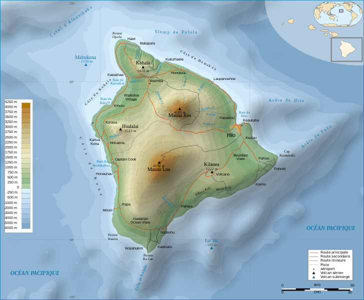
| 2008. gada 17. aprīlis, plkst. 21.47 |  | 3 110 × 2 563 (996 KB) | Sémhur | == Description == {{Information |Description= {{en| Topographic Map in french of the island of Hawaii.}} {{fr| Carte topographique de l'île de Hawaii.}} |Source=Travail personnel. {{clr}} Sources : * Fond de carte : |
Faila lietojums
Šo failu izmanto šajā 1 lapā:
Globālais faila lietojums
Šīs Vikipēdijas izmanto šo failu:
- Izmantojums af.wikipedia.org
- Izmantojums ar.wikipedia.org
- Izmantojums bn.wikipedia.org
- Izmantojums crh.wikipedia.org
- Izmantojums cv.wikipedia.org
- Izmantojums en.wikipedia.org
- Izmantojums eo.wikipedia.org
- Izmantojums es.wikipedia.org
- Izmantojums eu.wikipedia.org
- Izmantojums fr.wikipedia.org
- Analogique
- Mauna Kea
- Mauna Loa
- Utilisateur:Sémhur
- Hawaï (île)
- Hualālai
- Discussion aide:Cartographie
- Discussion Wikipédia:Wikiconcours/mars 2008/Équipes/Équipe 5
- Projet:Impression/Wikigraphistes
- Utilisateur:Sémhur/Récompenses
- Wikipédia:Image du jour/juin 2010
- Wikipédia:Image du jour/16 juin 2010
- Kohala (volcan)
- Cap Kumukahi
- Phare du cap Kumukahi
- Discussion Wikipédia:Atelier graphique/Archive 10
- Izmantojums fr.wikinews.org
- Izmantojums hu.wikipedia.org
- Izmantojums id.wikipedia.org
- Izmantojums it.wikipedia.org
- Izmantojums ko.wikipedia.org
- Izmantojums krc.wikipedia.org
- Izmantojums lbe.wikipedia.org
- Izmantojums mg.wikipedia.org
- Izmantojums mk.wikipedia.org
- Izmantojums mt.wikipedia.org
- Izmantojums oc.wikipedia.org
Skatīt šī faila pilno globālo izmantojumu.