
Attēls:Indianapolis Motor Speedway - road course.svg

Size of this PNG preview of this SVG file: 800 × 407 pikseļi. Citi izmēri: 320 × 163 pikseļi | 640 × 326 pikseļi | 1 024 × 521 pikseļi | 1 280 × 651 pikseļi | 2 560 × 1 303 pikseļi | 1 189 × 605 pikseļi.
Sākotnējais fails (SVG fails, definētais izmērs 1 189 × 605 pikseļi, faila izmērs: 31 KB)
| Šis fails ir no Vikikrātuves. Tā apraksts no attēla lapas Vikikrātuvē ir parādīts zemāk. Vikikrātuve ir brīvi licencēta failu krātuve. Tu vari tai palīdzēt. |
Kopsavilkums
| Apraksts |
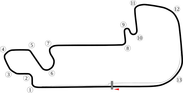
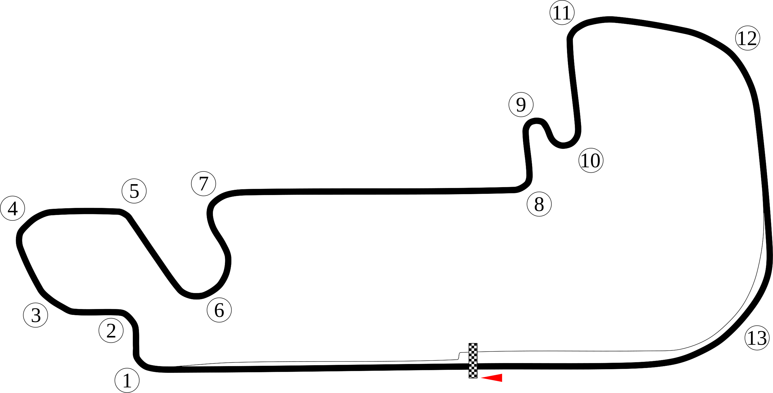
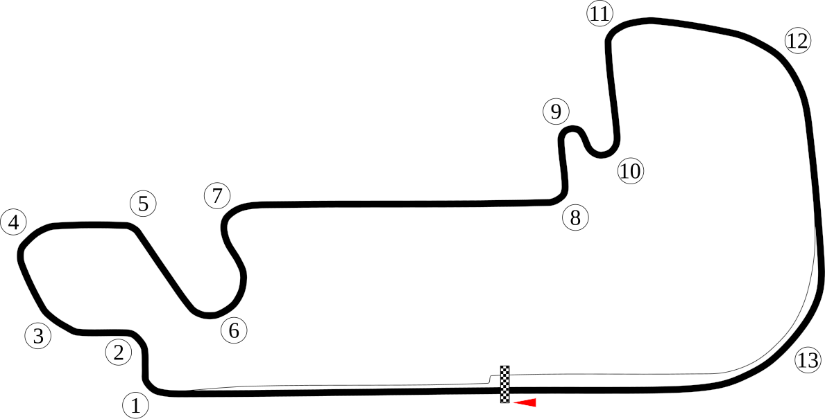
English: Map of the road course of Indianapolis Motor Speedway. |
| Datums | |
| Avots | Paša darbs |
| Autors | Will Pittenger |
| Citas versijas |
|


| Camera location | | View this and other nearby images on: OpenStreetMap |
|---|
Licence
| I, the copyright holder of this work, release this work into the public domain. This applies worldwide. In some countries this may not be legally possible; if so: I grant anyone the right to use this work for any purpose, without any conditions, unless such conditions are required by law. |
Faila hronoloģija
Uzklikšķini uz datums/laiks kolonnā esošās saites, lai apskatītos, kā šis fails izskatījās tad.
| Datums/Laiks | Attēls | Izmēri | Dalībnieks | Komentārs | |
|---|---|---|---|---|---|
| tagadējais | 2008. gada 12. jūlijs, plkst. 14.23 | | 1 189 × 605 (31 KB) | Will Pittenger | {{Information |Description={{en|1=Map of the road course of w:Indianapolis Motor Speedway.}} |Source=Own work by uploader |Author=Will Pittenger |Date=6-24-2008 |Permission= |other_versions=[[:Image:Indianapolis Motor Speedway |
Faila lietojums
Šo failu izmanto šajās 3 lapās:
Globālais faila lietojums
Šīs Vikipēdijas izmanto šo failu:
- Izmantojums af.wikipedia.org
- Izmantojums ar.wikipedia.org
- جائزة الولايات المتحدة الكبرى 2007
- جائزة الولايات المتحدة الكبرى 2006
- جائزة الولايات المتحدة الكبرى 2002
- جائزة الولايات المتحدة الكبرى 2001
- جائزة الولايات المتحدة الكبرى 2000
- جائزة الولايات المتحدة الكبرى 2005
- جائزة الولايات المتحدة الكبرى 2004
- جائزة الولايات المتحدة الكبرى 2003
- جائزة الولايات المتحدة الكبرى
- Izmantojums ast.wikipedia.org
- Izmantojums bg.wikipedia.org
- Izmantojums bn.wikipedia.org
- Izmantojums br.wikipedia.org
- Izmantojums bs.wikipedia.org
- Izmantojums cs.wikipedia.org
- Izmantojums de.wikipedia.org
- Izmantojums el.wikipedia.org
- Izmantojums en.wikipedia.org
- Indianapolis Motor Speedway
- United States Grand Prix
- List of Formula One circuits
- 2003 United States Grand Prix
- 2000 United States Grand Prix
- 2001 United States Grand Prix
- 2002 United States Grand Prix
- 2004 United States Grand Prix
- 2005 United States Grand Prix
- 2006 United States Grand Prix
- 2007 United States Grand Prix
- User talk:Chubbennaitor/archive2
- User talk:Barkjon/Archive 2
Skatīt šī faila pilno globālo izmantojumu.