
Attēls:Italy 1000 AD.svg

Size of this PNG preview of this SVG file: 418 × 600 pikseļi. Citi izmēri: 167 × 240 pikseļi | 334 × 480 pikseļi | 535 × 768 pikseļi | 713 × 1 024 pikseļi | 1 427 × 2 048 pikseļi | 565 × 811 pikseļi.
Sākotnējais fails (SVG fails, definētais izmērs 565 × 811 pikseļi, faila izmērs: 861 KB)
| Šis fails ir no Vikikrātuves. Tā apraksts no attēla lapas Vikikrātuvē ir parādīts zemāk. Vikikrātuve ir brīvi licencēta failu krātuve. Tu vari tai palīdzēt. |
Kopsavilkums
| Apraksts |
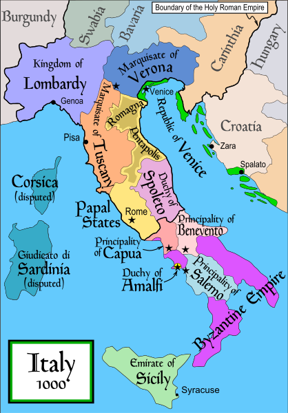
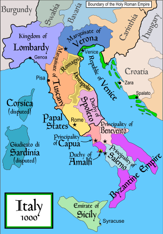
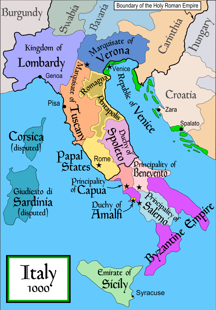
English: Political map of Italy in 1000 AD (CE). Created by MapMaster.
Part of a series of maps on the history of Italy:
|
| Datums | 2006. gada 17. novembris (original upload date) |
| Avots | No machine-readable source provided. Own work assumed (based on copyright claims). |
| Autors | No machine-readable author provided. MapMaster assumed (based on copyright claims). |
| Citas versijas |
[]
SVG:
PNG:
|


|
This SVG file contains embedded text that can be translated into your language, using any capable SVG editor, text editor or the SVG Translate tool. For more information see: About translating SVG files. |
References
- Bjorklund, Oddvar; Holmboe, Haakon; Rohr, Anders (1970) Historical Atlas of the World, Barnes & Noble, NY, SBN: 389-00253-4.
- This map from Allyn & Bacon, Longman, textbook publishers.
- This map of the w:en:Holy Roman Empire
- A map from Attilios
- This map of 1050 AD Italy, from the 1923 The Historical Atlas by William R. Shepherd
- This map of 1000 AD Italy from Fordham University, adapted from Muir's Historical Atlas, (1911).
In addition, a number of other sources were consulted in an effort to determine the following matters:
- The extent of Venetian control over the cities of Dalmatia such as Zara and Spalato. Although the Venetians had been pushed off the mainland earlier, in the period around the year 1000, the Venetians made an effort to recover these cities.
- The extent of Saracen control over Corsica and Sardinia. Information is sparse. The apparent situation is that the Muslims had several bases on the coasts of these islands, but did not control the countryside (such as they did in Sicily).
- Whether or not the principalities of Capua and Benevento were separate states in the year 1000. Based on lists of their rulers (various Pandulfs and Landulfs), the answer seems to be "yes".
- Who controlled the Balkans on the southeastern border of the Kingdom of Croatia. Candidates include Bulgaria, the Byzantine Empire, Croatia, and Serbia.
As noted, there is significant disagreement among sources on these questions.
This map was commissioned by Attilios, and there is also a discussion to be found on MapMaster's English talk page.
Licence
Es, šī darba autortiesību īpašnieks, publicēju to saskaņā ar šo licenci:

|
Ir dota atļauja kopēt, izplatīt un/vai pārveidot šo dokumentu saskaņā ar GNU brīvās dokumentācijas licences, versijas 1.2 vai jebkuras vēlākas versijas, ko publiskojis Brīvās programmatūras fonds nosacījumiem; bez nemainīgajām sadaļā, priekšējā un aizmugurēja'vāka tekstiem. Licences kopija ir iekļauta sadaļā ar nosaukumu GNU brīvās dokumentācijas licence. |
| Šis fails tiek izplatīts saskaņā ar licences Creative Commons Atsauce-Līdzīgi Noteikumi 3.0 Vispārējiem noteikumiem. | ||
| ||
| This licensing tag was added to this file as part of the GFDL licensing update. |
derivative works
Derivative works of this file: Italya MS 1000.svg
Faila hronoloģija
Uzklikšķini uz datums/laiks kolonnā esošās saites, lai apskatītos, kā šis fails izskatījās tad.
| Datums/Laiks | Attēls | Izmēri | Dalībnieks | Komentārs | |
|---|---|---|---|---|---|
| tagadējais | 2007. gada 17. aprīlis, plkst. 22.50 | | 565 × 811 (861 KB) | MapMaster | Some further changes |
| 2007. gada 19. februāris, plkst. 08.10 |  | 565 × 811 (824 KB) | MapMaster | changes to ensure consistency with my other Italy maps | |
| 2006. gada 25. novembris, plkst. 08.39 |  | 565 × 811 (823 KB) | MapMaster | Improved map. | |
| 2006. gada 18. novembris, plkst. 17.44 |  | 565 × 811 (827 KB) | MapMaster | Improved (I hope) version based on recommendations from Attilios. | |
| 2006. gada 18. novembris, plkst. 00.50 |  | 565 × 811 (768 KB) | MapMaster | Political map of Italy in 1000 AD (CE). |
Faila lietojums
Šo failu izmanto šajās 6 lapās:
Globālais faila lietojums
Šīs Vikipēdijas izmanto šo failu:
- Izmantojums an.wikipedia.org
- Izmantojums ar.wikipedia.org
- Izmantojums ast.wikipedia.org
- Izmantojums azb.wikipedia.org
- Izmantojums az.wikipedia.org
- Izmantojums bg.wikipedia.org
- Izmantojums bn.wikipedia.org
- Izmantojums bs.wikipedia.org
- Izmantojums ckb.wikipedia.org
- Izmantojums cs.wikipedia.org
- Izmantojums da.wikipedia.org
- Izmantojums de.wikipedia.org
- Izmantojums el.wikipedia.org
- Izmantojums en.wikipedia.org
- Lombards
- Pope Stephen IX
- Otto III, Holy Roman Emperor
- Otto II, Holy Roman Emperor
- Salerno
- Benevento
- Emirate
- Italian city-states
- List of historical states of Italy
- List of state leaders in the 10th century
- Duchy of Spoleto
- Duchy of Benevento
- Kalbids
- Guaimar IV of Salerno
- Rainulf Drengot
- Duchy of Amalfi
- Emirate of Sicily
- Sergius IV of Naples
Skatīt šī faila pilno globālo izmantojumu.