
Attēls:Karluk voyage map.png

Šī priekšskata izmērs: 800 × 537 pikseļi. Citi izmēri: 320 × 215 pikseļi | 640 × 429 pikseļi | 1 002 × 672 pikseļi.
Sākotnējais fails (1 002 × 672 pikseļi, faila izmērs: 198 KB, MIME tips: image/png)
| Šis fails ir no Vikikrātuves. Tā apraksts no attēla lapas Vikikrātuvē ir parādīts zemāk. Vikikrātuve ir brīvi licencēta failu krātuve. Tu vari tai palīdzēt. |

|
This map image could be re-created using vector graphics as an SVG file. This has several advantages; see Commons:Media for cleanup for more information. If an SVG form of this image is available, please upload it and afterwards replace this template with
{{vector version available|new image name}}.
It is recommended to name the SVG file “Karluk voyage map.svg”—then the template Vector version available (or Vva) does not need the new image name parameter. |
Kopsavilkums
| Apraksts |
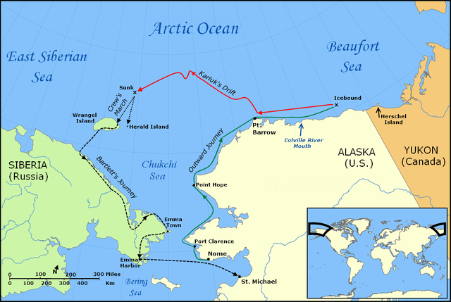
English: Map of the Voyage of the Karluk, including the outbound journey from Nome, the ship's drift in Arctic pack ice, the crew's icy march to Wrangel Island, and Captain Bartlett's journey on foot from Wrangel Island to Emma Harbor in Siberia, and then by ship to St. Michael, Alaska |
| Datums | |
| Avots |
Own work using:
|
| Autors | Finetooth; NormanEinstein |
| Citas versijas |
Derivative works of this file: |
Licence
Es, šī darba autortiesību īpašnieks, publicēju to saskaņā ar šīm licencēm:

|
Ir dota atļauja kopēt, izplatīt un/vai pārveidot šo dokumentu saskaņā ar GNU brīvās dokumentācijas licences, versijas 1.2 vai jebkuras vēlākas versijas, ko publiskojis Brīvās programmatūras fonds nosacījumiem; bez nemainīgajām sadaļā, priekšējā un aizmugurēja'vāka tekstiem. Licences kopija ir iekļauta sadaļā ar nosaukumu GNU brīvās dokumentācijas licence. |
Šis fails tiek izplatīts saskaņā ar licences Creative Commons Atsauce-Līdzīgi Noteikumi 3.0 Vispārējiem noteikumiem.
- Jūs varat brīvi:
- koplietot – kopēt, izplatīt un pārraidīt darbu
- remiksēt – pielāgot darbu
- Saskaņā ar šādiem nosacījumiem:
- atsaucoties – Tev ir jānorāda autors, saite uz licenci un to, vai veiktas kādas izmaiņas. To var darīt jebkādā saprātīgā veidā, bet ne tādā, kas norādītu, ka licencētājs atbalsta tevi vai veidu, kā tu izmanto šo darbu.
- nemainot licenci – Ja tu miksē, pārveido vai izmanto materiālu, tev savs devums jāpublicē ar to pašu vai saderīgu licenci kā oriģināls.
Jūs varat izvēlēties licenci pēc jūsu vēlmes.
Faila hronoloģija
Uzklikšķini uz datums/laiks kolonnā esošās saites, lai apskatītos, kā šis fails izskatījās tad.
| Datums/Laiks | Attēls | Izmēri | Dalībnieks | Komentārs | |
|---|---|---|---|---|---|
| tagadējais | 2010. gada 30. janvāris, plkst. 21.36 | | 1 002 × 672 (198 KB) | Finetooth | Added black border to left edge. |
| 2010. gada 28. janvāris, plkst. 05.33 |  | 1 002 × 672 (198 KB) | Finetooth | Added directional arrow to map scale | |
| 2010. gada 28. janvāris, plkst. 05.12 |  | 1 002 × 672 (198 KB) | Finetooth | Added map scale, moved Bering Sea text slightly to reduce clutter | |
| 2010. gada 28. janvāris, plkst. 05.12 |  | 1 002 × 672 (198 KB) | Finetooth | Added map scale, moved Bering Sea text slightly to reduce clutter | |
| 2010. gada 27. janvāris, plkst. 21.07 |  | 1 002 × 672 (195 KB) | Finetooth | Corrected placement of Port Clarence, moved Arctic Ocean and Beaufort Sea labels to the right and changed font to match East Siberian Sea | |
| 2010. gada 27. janvāris, plkst. 08.42 |  | 1 002 × 672 (184 KB) | Finetooth | Cropped, added colour to outward voyage and drift in ice, increased font size of voyage-segment text to improve readability, added Emma Town, Port Hope, Port Clarence, mouth of the Colville River, Herald Island and Herschel Island, made Bartlett's journey | |
| 2010. gada 26. janvāris, plkst. 06.11 |  | 1 200 × 672 (312 KB) | Finetooth | {{Information |Description={{en|1=Map of the Voyage of the ''Karluk'', including the outbound journey from Nome, the ship's drift in Arctic pack ice, the crew's icy march to Wrangel Island, and Captain Bartlett's journey on foot from Wrangel Island to Emm |
Faila lietojums
Šo failu izmanto šajā 1 lapā:
Globālais faila lietojums
Šīs Vikipēdijas izmanto šo failu:
- Izmantojums en.wikipedia.org
- Izmantojums fr.wikipedia.org
- Izmantojums nl.wikipedia.org
- Izmantojums pt.wikipedia.org
- Izmantojums ru.wikipedia.org