
Attēls:KeizersgrachtReguliersgrachtAmsterdam.jpg

Šī priekšskata izmērs: 800 × 533 pikseļi. Citi izmēri: 320 × 213 pikseļi | 640 × 427 pikseļi | 1 024 × 683 pikseļi | 1 280 × 853 pikseļi | 2 560 × 1 707 pikseļi | 3 456 × 2 304 pikseļi.
Sākotnējais fails (3 456 × 2 304 pikseļi, faila izmērs: 4,91 MB, MIME tips: image/jpeg)
| Šis fails ir no Vikikrātuves. Tā apraksts no attēla lapas Vikikrātuvē ir parādīts zemāk. Vikikrātuve ir brīvi licencēta failu krātuve. Tu vari tai palīdzēt. |
Kopsavilkums
| Apraksts |
Nederlands: Zicht op de Reguliersgracht op de hoek met de Keizersgracht in Amsterdam, Nederland bij het ondergaan van de zon.
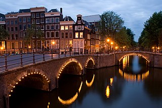
English: A view of the Reguliersgracht on the corner with the Keizersgracht, in Amsterdam, the Netherlands at dusk.
Afrikaans: Amsterdamse gragte tydens skemer, die Reguliersgrag by die aansluiting met die Keizersgrag
Čeština: Křižovatka dvou kanálů (Reguliersgracht a Keizersgracht) v nizozemském Amsterdamu za soumraku.
Dansk: Udsigt over Reguliersgracht i Amsterdam, Holland, hvor den krydser Keizersgracht.
Deutsch: Kreuzung zweier Grachten (Reguliersgracht und Keizersgracht) in der niederländischen Hauptstadt Amsterdam in der Abenddämmerung.
Esperanto: Interkruciĝo de kanaloj Reguliersgracht kaj Keizersgracht je noktiĝo en Amsterdamo.
Español: Vista al atardecer del Keizersgracht, Ámsterdam, Países Bajos.
Français : Une vue de la Reguliersgracht au croisement de la Keizersgracht, au crépuscule à Amsterdam (Pays-Bas).
Magyar: Amszterdami részlet a Keizersgracht és a Reguliersgracht csatornák összefolyásánál
Македонски: Поглед на Регулирсграхт на аголот со Кајзерсграхт во Амстердам, Холандија, во мугри.
Polski: Widok skrzyżowania Amsterdamskich kanałów Reguliersgracht i Keizersgracht o zmierzchu.
Português: Vista ao entardecer do canal Regulier no cruzamento com o Keizer, Amsterdã, Países Baixos.
Română: Reguliersgracht, colţ cu Keizersgracht, în Amsterdam, Olanda la amurg.
Русский: «Перекрёсток» двух каналов, Reguliersgracht и Keizersgracht, в сумерках (Амстердам, Нидерланды)
Українська: На перехресті двох амстердамських каналів, Реґулірсґрахт (Reguliersgracht) та Кайзерсґрахт (Keizersgracht) у сутінкову пору.
中文(简体):荷兰阿姆斯特丹平凡运河和国王运河交汇处夜景
中文(繁體):荷蘭阿姆斯特丹修士運河和國王運河交匯處夜景
|
||||||||||||
| Datums | |||||||||||||
| Avots | Paša darbs | ||||||||||||
| Autors | Massimo Catarinella | ||||||||||||
| Atļauja: (Šī faila izmantošana citur) |
See license, attribution required - contact me to discuss less restrictive commercial licensing terms by email Special:EmailUser/Massimo Catarinella or leave a message on my talk page | ||||||||||||
| Citas versijas |


.jpg)
| Camera location | | View this and other nearby images on: OpenStreetMap |
|---|
This image was selected as picture of the day on Wikimedia Commons for 8 December 2008. It was captioned as follows: English: A view of the Reguliersgracht on the corner with the Keizersgracht, in Amsterdam, The Netherlands at dusk. Other languages:
Afrikaans: Amsterdamse gragte tydens skemer, die Reguliersgrag by die aansluiting met die Keizersgrag. Čeština: Křižovatka dvou kanálů (Reguliersgracht a Keizersgracht) v nizozemském Amsterdamu za soumraku. Deutsch: Kreuzung zweier Grachten (Reguliersgracht und Keizersgracht) in der niederländischen Hauptstadt Amsterdam in der Abenddämmerung. English: A view of the Reguliersgracht on the corner with the Keizersgracht, in Amsterdam, The Netherlands at dusk. Esperanto: Interkruciĝo de kanaloj Reguliersgracht kaj Keizersgracht je noktiĝo en Amsterdamo. Français : Intersection entre deux canaux (Reguliersgracht et Keizersgracht) à la tombée de la nuit à Amsterdam. Nederlands: Zicht op de Reguliersgracht op de hoek met de Keizersgracht in Amsterdam, Nederland bij het ondergaan van de zon. Polski: Widok skrzyżowania amsterdamskich kanałów Reguliersgracht i Keizersgracht o zmierzchu. Português: Vista ao entardecer do canal Regulier no cruzamento com o Keizer, Amsterdã, Países Baixos. Русский: «Перекрёсток» двух каналов, Reguliersgracht и Keizersgracht, в сумерках (Амстердам, Нидерланды) Українська: На перехресті двох амстердамських каналів, Реґулірсґрахт (Reguliersgracht) та Кайзерсґрахт (Keizersgracht) у сутінкову пору. 中文: 荷兰阿姆斯特丹修士运河和国王运河交汇处夜景 |
|
Licence
Es, šī darba autortiesību īpašnieks, publicēju to saskaņā ar šo licenci:
Šis fails tiek izplatīts saskaņā ar licences Creative Commons Atsauce-Līdzīgi Noteikumi 3.0 Vispārējiem noteikumiem.
- Jūs varat brīvi:
- koplietot – kopēt, izplatīt un pārraidīt darbu
- remiksēt – pielāgot darbu
- Saskaņā ar šādiem nosacījumiem:
- atsaucoties – Tev ir jānorāda autors, saite uz licenci un to, vai veiktas kādas izmaiņas. To var darīt jebkādā saprātīgā veidā, bet ne tādā, kas norādītu, ka licencētājs atbalsta tevi vai veidu, kā tu izmanto šo darbu.
- nemainot licenci – Ja tu miksē, pārveido vai izmanto materiālu, tev savs devums jāpublicē ar to pašu vai saderīgu licenci kā oriģināls.
| Annotations | This image is annotated: View the annotations at Commons |
Faila hronoloģija
Uzklikšķini uz datums/laiks kolonnā esošās saites, lai apskatītos, kā šis fails izskatījās tad.
| Datums/Laiks | Attēls | Izmēri | Dalībnieks | Komentārs | |
|---|---|---|---|---|---|
| tagadējais | 2009. gada 25. augusts, plkst. 02.13 | | 3 456 × 2 304 (4,91 MB) | Massimo Catarinella | sRGB |
| 2008. gada 13. augusts, plkst. 21.31 |  | 3 456 × 2 304 (1,11 MB) | Massimo Catarinella | {{Information |Description={{en|1=A view of the Keizersgracht on the corner with the Reguliersgracht in Amsterdam, The Netherlands at dawn.}} |Source=Own work by uploader |Author=Massimo Catarinella |Date=11 August 2008 |Permi |
Faila lietojums
Šo failu izmanto šajā 1 lapā:
Globālais faila lietojums
Šīs Vikipēdijas izmanto šo failu:
- Izmantojums an.wikipedia.org
- Izmantojums ar.wikipedia.org
- Izmantojums ary.wikipedia.org
- Izmantojums arz.wikipedia.org
- Izmantojums awa.wikipedia.org
- Izmantojums az.wikipedia.org
- Izmantojums ba.wikipedia.org
- Izmantojums bg.wikipedia.org
- Izmantojums bh.wikipedia.org
- Izmantojums bn.wikipedia.org
- Izmantojums co.wikipedia.org
- Izmantojums crh.wikipedia.org
- Izmantojums cs.wikipedia.org
- Izmantojums cu.wikipedia.org
- Izmantojums cv.wikipedia.org
- Izmantojums de.wikipedia.org
- Izmantojums el.wikivoyage.org
- Izmantojums en.wikipedia.org
- Amsterdam
- User talk:Ilse@
- Category talk:Geography
- Portal:Netherlands
- Portal:Architecture
- Portal:Geography/Featured picture archive
- Wikipedia:WikiProject Urban studies and planning
- Portal:European Union/Selected picture
- Wikipedia:Featured pictures/Places/Urban
- Portal:Architecture/Townscape images
- Portal:European Union/Selected picture/23
- User talk:Ilse@/archive
- Wikipedia:WikiProject Netherlands
- Wikipedia talk:WikiProject Cities/Archive 8
- User:Massimo Catarinella
- User talk:Massimo Catarinella
- Wikipedia:Featured pictures thumbs/13
- Wikipedia:Featured picture candidates/Keizersgracht in Amsterdam
- Wikipedia:Wikipedia Signpost/2008-09-08/Features and admins
- Wikipedia:Featured picture candidates/September-2008
- Wikipedia:Wikipedia Signpost/2008-09-08/SPV
- Wikipedia:Picture peer review/Architecture in Amsterdam
- User:Mzajac/Infobox settlement
- Wikipedia:Picture peer review/Archives/Jan-Mar 2009
- Wikipedia:Picture of the day/April 2009
Skatīt šī faila pilno globālo izmantojumu.