
Attēls:Leuchtturm in Westerheversand.jpg
Šī priekšskata izmērs: 800 × 600 pikseļi. Citi izmēri: 320 × 240 pikseļi | 640 × 480 pikseļi | 1 024 × 768 pikseļi | 1 280 × 960 pikseļi | 2 560 × 1 919 pikseļi | 3 860 × 2 894 pikseļi.
Sākotnējais fails (3 860 × 2 894 pikseļi, faila izmērs: 12,13 MB, MIME tips: image/jpeg)
| Šis fails ir no Vikikrātuves. Tā apraksts no attēla lapas Vikikrātuvē ir parādīts zemāk. Vikikrātuve ir brīvi licencēta failu krātuve. Tu vari tai palīdzēt. |
Kopsavilkums
| Apraksts |
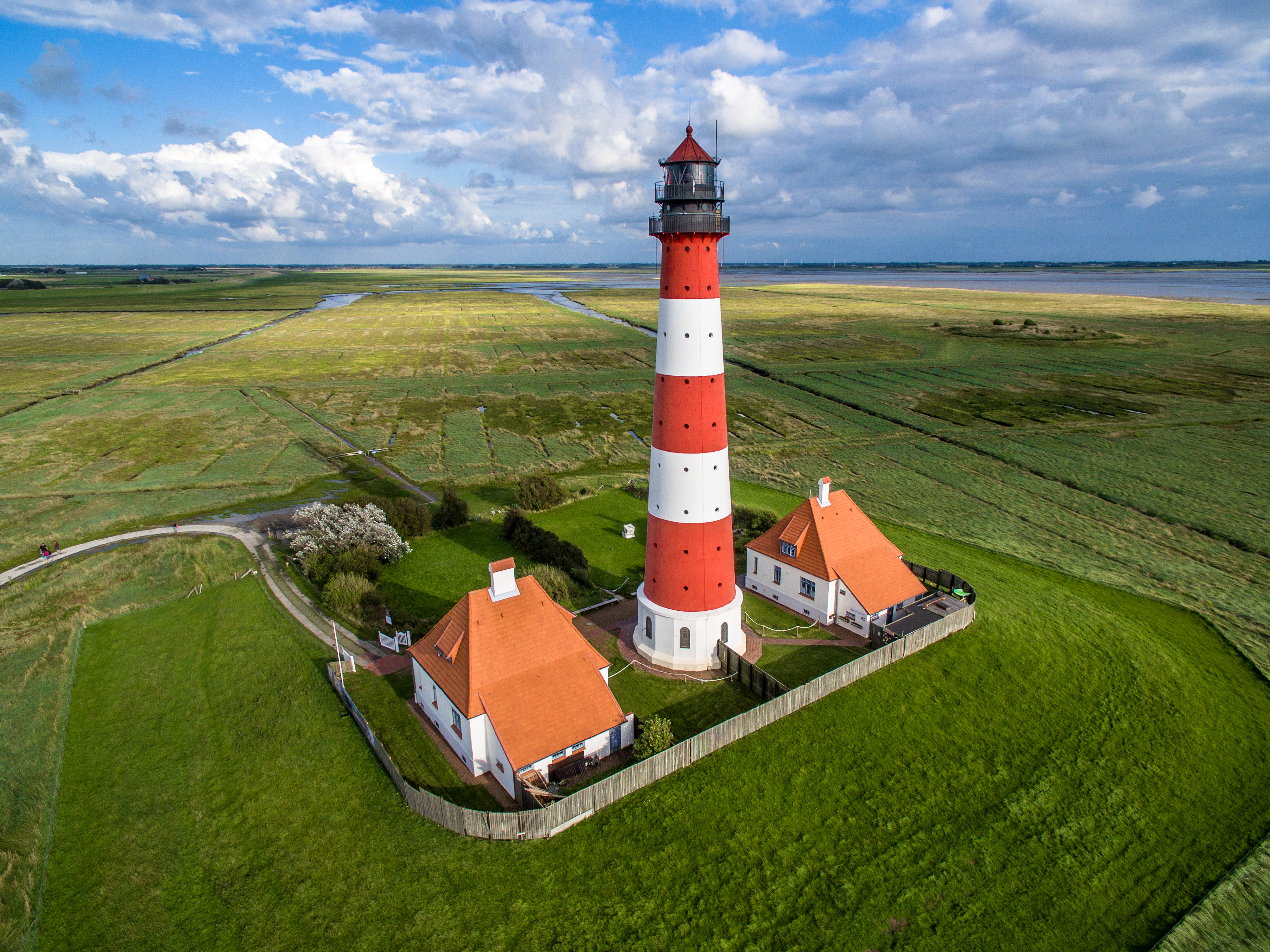
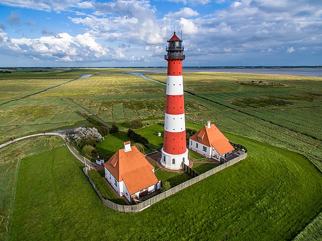
Deutsch: Luftbildaufnahme des Leuchtturms in Westerheversand
English: Aerial photograph of Westerheversand Lighthouse
Esperanto: Aera bildo de la lumturo de Westerheversand
Español: Veduta aérea del faro de Westerheversand
Euskara: Westerheversandeko itsasargiaren aireko bista
Français : Vue aérienne du phare de Westerheversand
Русский: Аэрофотосъемка Вестерхеферского маяка
Українська: Аерофотозйомка Вестергеферського маяка, Шлезвіг-Гольштейн, Німеччина |
| Datums | |
| Avots | Paša darbs |
| Autors | Marco Leiter |
| Citas versijas |
|

| Object location | | View this and other nearby images on: OpenStreetMap |
|---|
| Camera location | | View this and other nearby images on: OpenStreetMap |
|---|
Notes

|
Šis attēls tika augšupielādēts konkursa "Kultūras pieminekļi Vikipēdijā 2015" ietvaros.
|
Assessment

|
This image was awarded with the 1st prize worldwide in Wiki Loves Monuments 2015 Other languages:
|
This image has been assessed using the Quality image guidelines and is considered a Quality image.
|
Licence
- Object
|
The photographical reproduction of this work is covered under the article § 59 of the German copyright law, which states that "It shall be permissible to reproduce, by painting, drawing, photography or cinematography, works which are permanently located on public ways, streets or places and to distribute and publicly communicate such copies. For works of architecture, this provision shall be applicable only to the external appearance."
As with all other “limits of copyright by legally permitted uses”, no changes to the actual work are permitted under § 62 of the German copyright law (UrhG). See Commons:Copyright rules by territory/Germany#Freedom of panorama for more information.
|
- Fotoattēls
Es, šī darba autortiesību īpašnieks, publicēju to saskaņā ar šo licenci:
This file is licensed under the Creative Commons Attribution-Share Alike 4.0 International license.
- Jūs varat brīvi:
- koplietot – kopēt, izplatīt un pārraidīt darbu
- remiksēt – pielāgot darbu
- Saskaņā ar šādiem nosacījumiem:
- atsaucoties – Tev ir jānorāda autors, saite uz licenci un to, vai veiktas kādas izmaiņas. To var darīt jebkādā saprātīgā veidā, bet ne tādā, kas norādītu, ka licencētājs atbalsta tevi vai veidu, kā tu izmanto šo darbu.
- nemainot licenci – Ja tu miksē, pārveido vai izmanto materiālu, tev savs devums jāpublicē ar to pašu vai saderīgu licenci kā oriģināls.
Faila hronoloģija
Uzklikšķini uz datums/laiks kolonnā esošās saites, lai apskatītos, kā šis fails izskatījās tad.
| Datums/Laiks | Attēls | Izmēri | Dalībnieks | Komentārs | |
|---|---|---|---|---|---|
| tagadējais | 2016. gada 8. septembris, plkst. 23.04 | | 3 860 × 2 894 (12,13 MB) | Nightflyer | Bearbeitet: Am rechten Rand war eine 1 Pixel breite weisse Linie. |
| 2015. gada 24. oktobris, plkst. 14.02 |  | 3 861 × 2 894 (8,74 MB) | Phantom3Pix | Mit Hilfe von Nightflyer unzählige Staubflecken im Himmel entfernt, Horizont begradigt und leicht nachgedunkelt. | |
| 2015. gada 22. oktobris, plkst. 19.12 |  | 3 992 × 2 992 (9,94 MB) | Phantom3Pix | Reverted to version as of 20:33, 19 October 2015 (UTC) | |
| 2015. gada 22. oktobris, plkst. 17.54 |  | 3 931 × 2 946 (8,78 MB) | Phantom3Pix | Turm im Lot. | |
| 2015. gada 19. oktobris, plkst. 23.33 |  | 3 992 × 2 992 (9,94 MB) | Phantom3Pix | Bildkorrektur | |
| 2015. gada 13. septembris, plkst. 18.56 |  | 3 992 × 2 992 (9,94 MB) | Phantom3Pix | User created page with UploadWizard |
Faila lietojums
Šo failu izmanto šajās 2 lapās:
Globālais faila lietojums
Šīs Vikipēdijas izmanto šo failu:
- Izmantojums ar.wikipedia.org
- Izmantojums bn.wikipedia.org
- Izmantojums ca.wikipedia.org
- Izmantojums cs.wikipedia.org
- Izmantojums de.wikipedia.org
- Portal:Schleswig-Holstein
- Wiki Loves Monuments
- Wikipedia:Wiki Loves Monuments 2015/Deutschland/Preisträger
- Benutzer:Aeroid/Waddensea
- Wikipedia:Kurier/Ausgabe 10 2015
- Wikipedia Diskussion:Kurier/Archiv/2015/12
- Wikipedia:Lokal K/Drohnenfotografie
- Wikipedia:Kurier/Ausgabe 12 2015
- Wikipedia Diskussion:Wiki Loves Monuments 2016/Deutschland
- Wikipedia:Kurier/Ausgabe 1 2016
- Benutzer:Markus Bärlocher/Leuchtfeuer
- Wikipedia:Wiki Loves Monuments 2016/Deutschland/Rückblick
- Wikipedia:Wiki Loves Monuments 2016/Deutschland/Mitmachen/Bilder verwenden
- Wikipedia:Wiki Loves Monuments 2017/Deutschland/Rückblick
- Wikipedia:Wiki Loves Monuments 2017/Deutschland/Mitmachen/Nutzen
- Wikipedia:Wiki Loves Monuments 2018/Deutschland/Rückblick
- Wikipedia:Wiki Loves Monuments 2018/Deutschland
- Benutzer:Martin Rulsch (WMDE)/Test3
- Wikipedia:Wiki Loves Monuments 2018/Deutschland/Nutzen
- Benutzer:Magnus Manske/Kulturdenkmale Schleswig-Holstein U-Z
- Wikipedia:Wiki Loves Monuments 2019/Deutschland/Rückblick
- Wikipedia:Wiki Loves Monuments 2019/Deutschland/Nutzen
- Benutzer:Akuckartz
- Wikipedia:Wiki Loves Monuments 2020/Deutschland/Nutzen
- Wikipedia:Wiki Loves Monuments 2020/Deutschland/Rückblick
- Wikipedia:Wiki Loves Monuments 2021/Deutschland/Nutzen
- Wikipedia:Wiki Loves Monuments 2021/Deutschland/Rückblick
- Wikipedia:Wiki Loves Monuments 2022/Deutschland/Nutzen
- Wikipedia:Wiki Loves Monuments 2022/Deutschland/Rückblick
- Schleswig-Holsteinische Marschen und Nordseeinseln
- Wikipedia:Wiki Loves Monuments 2023/Deutschland/Nutzen
- Wikipedia:Wiki Loves Monuments 2023/Deutschland/Preise
- Izmantojums de.wikivoyage.org
- Izmantojums dty.wikipedia.org
- Izmantojums el.wikipedia.org
- Izmantojums en.wikipedia.org
Skatīt šī faila pilno globālo izmantojumu.