
Attēls:Livland 15jh.png
Šī priekšskata izmērs: 666 × 599 pikseļi. Citi izmēri: 267 × 240 pikseļi | 533 × 480 pikseļi | 1 000 × 900 pikseļi.
Sākotnējais fails (1 000 × 900 pikseļi, faila izmērs: 2,23 MB, MIME tips: image/png)
| Šis fails ir no Vikikrātuves. Tā apraksts no attēla lapas Vikikrātuvē ir parādīts zemāk. Vikikrātuve ir brīvi licencēta failu krātuve. Tu vari tai palīdzēt. |
Kopsavilkums
| Apraksts |
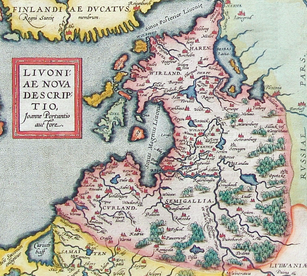
latīņu:
Livoniae nova descriptio, Joanne Portantio auctore. Deutsch: Historische Karte von Livland, vermutlich im 15. Jahrhundert.
English: Historical map of Livonian Confederation, Antwerpen, 1573–1598. First published in Theatrum Orbis Terrarum (1570–1612) by Abraham Ortelius.
22 × 24 cm |
| Datums | 1573. gada - 1598. gada |
| Avots |
Deutsch: Erbstück
Scan by Exxu |
| Autors | Joannes Portantius |
| Citas versijas |
 |
Licence
|
This work is in the public domain in its country of origin and other countries and areas where the copyright term is the author's life plus 100 years or fewer. | |
| This file has been identified as being free of known restrictions under copyright law, including all related and neighboring rights. | |
Faila hronoloģija
Uzklikšķini uz datums/laiks kolonnā esošās saites, lai apskatītos, kā šis fails izskatījās tad.
| Datums/Laiks | Attēls | Izmēri | Dalībnieks | Komentārs | |
|---|---|---|---|---|---|
| tagadējais | 2006. gada 12. novembris, plkst. 03.01 | | 1 000 × 900 (2,23 MB) | MapMaster | Beschreibung: Historische Karte von Livland, vermutlich 15. Jahrhundert Description: Historical map of Livonia, likely 15th century Quelle: Erbstück Urheber: unbekannt Datum vermutlich: 15. Jahrhundert Scan by Benutzer:Exxu This is a copy of [[w:de::Bil |
Faila lietojums
Šo failu izmanto šajās 2 lapās:
Globālais faila lietojums
Šīs Vikipēdijas izmanto šo failu:
- Izmantojums ar.wikipedia.org
- Izmantojums be-tarask.wikipedia.org
- Izmantojums be.wikipedia.org
- Izmantojums ca.wikipedia.org
- Izmantojums da.wikipedia.org
- Izmantojums de.wikipedia.org
- Izmantojums en.wikipedia.org
- Izmantojums eo.wikipedia.org
- Izmantojums et.wikipedia.org
- Izmantojums eu.wikipedia.org
- Izmantojums fr.wikipedia.org
- Izmantojums hu.wikipedia.org
- Izmantojums it.wikipedia.org
- Izmantojums ka.wikipedia.org
- Izmantojums la.wikipedia.org
- Izmantojums nl.wikipedia.org
- Izmantojums pt.wikipedia.org
- Izmantojums ru.wikipedia.org
- Izmantojums sh.wikipedia.org
- Izmantojums sk.wikipedia.org
- Izmantojums tr.wikipedia.org
- Izmantojums tt.wikipedia.org
- Izmantojums uk.wikipedia.org
- Izmantojums www.wikidata.org