
Attēls:Location-Europe-UNsubregions, Kosovo as part of Serbia.png

Šī priekšskata izmērs: 638 × 599 pikseļi. Citi izmēri: 256 × 240 pikseļi | 511 × 480 pikseļi | 984 × 924 pikseļi.
Sākotnējais fails (984 × 924 pikseļi, faila izmērs: 50 KB, MIME tips: image/png)
| Šis fails ir no Vikikrātuves. Tā apraksts no attēla lapas Vikikrātuvē ir parādīts zemāk. Vikikrātuve ir brīvi licencēta failu krātuve. Tu vari tai palīdzēt. |

|
File:Europe subregion map UN geoscheme.svg is a vector version of this file. It should be used in place of this PNG file when not inferior.
File:Location-Europe-UNsubregions, Kosovo as part of Serbia.png → File:Europe subregion map UN geoscheme.svg
For more information, see Help:SVG. |
 |

|
This map has been uploaded by Electionworld from en.wikipedia.org to enable the |
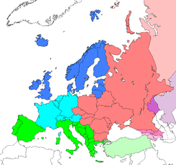
Map: Europe (location), subregions as delineated by United Nations geographic classification scheme:
- Asian portions of these countries
- Asian portions of these countries
Countries of Central Asia with partial territory in Eastern Europe – Kazakhstan
- Asian portions of these countries
Licence
| This work has been released into the public domain by its author, Electionworld. This applies worldwide. In some countries this may not be legally possible; if so: |
Original upload log
| date/time | username | resolution | size | edit summary |
|---|---|---|---|---|
| 16:25, 10 June 2008 | User:Milosevo | 984×924 | 50 KB | STOP VANDALISING! KOSOVO ISN'T A UN MEMBER, SO KOSOVO CAN'T BE IN A UN SUBREGION! |
| 13:28, 10 June 2008 | User:Cradel | 638×599 | 166 KB | Reverted to version as of 20:44, 9 June 2008jere |
| 12:07, 10 June 2008 | User:Milosevo | 984×924 | 50 KB | Reverted, again: kosovo isn't UN member, so it can't be in an UN subregion. |
| 20:44, 9 June 2008 | User:Cradel | 638×599 | 166 KB | Reverted to version as of 20:16, 8 June 2008 |
| 14:15, 9 June 2008 | User:Milosevo | 984×924 | 50 KB | kosovo isn't a UN member, so it can't be in an UN subregion. |
| 20:16, 8 June 2008 | User:Cradel | 638×599 | 166 KB | Reverted to version as of 18:17, 1 May 2008 |
| 10:17, 8 June 2008 | User:Milosevo | 984×924 | 50 KB | Reverted to version as of 23:06, 30 April 2008 |
| 18:17, 1 May 2008 | User:Cradel | 638×599 | 166 KB | Reverted vandalism |
| 23:06, 30 April 2008 | User:Serbish | 984×924 | 50 KB | Reverted to version as of 23:01, 29 January 2008 |
| 20:53, 7 April 2008 | User:Cradel | 638×599 | 166 KB | + Kosovo |
| 23:01, 29 January 2008 | User:Mahahahaneapneap | 984×924 | 50 KB | pngcrushed |
| 14:46, 3 December 2006 | User:Electionworld | 984×924 | 73 KB | {{ew|en|Cogito ergo sumo}} Map: <a href="/wiki/Europe" class="mw-redirect" title="Europe">Europe</a> (location), <a href="/w/index.php?title=Subregion&action=edit&redlink=1" class="new" title="Subregion (page does not exist)">subregions</a> as delineated by [http://unstats.un.org/unsd/methods/m49/m49regin.htm United Nations geographic classification scheme]:<br> {{legend|#4080FF|<a href="/w/index.php?title=Northern_Europe&action=edit&redlink=1" class="new" title="Northern Europe (page does not exist)">Northern Europe</a>}} {{legend|#00FFFF|[[Wes |
Faila hronoloģija
Uzklikšķini uz datums/laiks kolonnā esošās saites, lai apskatītos, kā šis fails izskatījās tad.
| Datums/Laiks | Attēls | Izmēri | Dalībnieks | Komentārs | |
|---|---|---|---|---|---|
| tagadējais | 2008. gada 8. augusts, plkst. 18.17 | | 984 × 924 (50 KB) | BetacommandBot | move approved by: User:Samulili This image was moved from Image:Location-Europe-UNsubregions.png {{ew|en|Cogito ergo sumo}} Map: Europe (location), subregions as delineated by [http://unstats.un.org/unsd/methods/m49/m49regin.htm United |
Faila lietojums
Šo failu izmanto šajās 3 lapās:
Globālais faila lietojums
Šīs Vikipēdijas izmanto šo failu:
- Izmantojums ace.wikipedia.org
- Izmantojums af.wikipedia.org
- Izmantojums ar.wikipedia.org
- Izmantojums be-tarask.wikipedia.org
- Izmantojums be.wikipedia.org
- Izmantojums bg.wikipedia.org
- Izmantojums bn.wikipedia.org
- Izmantojums br.wikipedia.org
- Izmantojums bs.wikipedia.org
- Izmantojums ceb.wikipedia.org
- Izmantojums crh.wikipedia.org
- Izmantojums cy.wikipedia.org
- Izmantojums da.wikipedia.org
- Izmantojums en.wikipedia.org
- Izmantojums en.wikivoyage.org
- Izmantojums eo.wikipedia.org
- Izmantojums eu.wikipedia.org
- Izmantojums fa.wikipedia.org
- Izmantojums fi.wikipedia.org
- Izmantojums fr.wikipedia.org
- Izmantojums fy.wikipedia.org
- Izmantojums fy.wiktionary.org
- Izmantojums gag.wikipedia.org
- Izmantojums gd.wikipedia.org
- Izmantojums gl.wikipedia.org
- Izmantojums id.wikipedia.org
- Izmantojums io.wikipedia.org
Skatīt šī faila pilno globālo izmantojumu.