
Attēls:Mödling.JPG

Šī priekšskata izmērs: 800 × 467 pikseļi. Citi izmēri: 320 × 187 pikseļi | 640 × 374 pikseļi | 1 024 × 598 pikseļi | 1 280 × 747 pikseļi | 2 560 × 1 495 pikseļi | 6 378 × 3 724 pikseļi.
Sākotnējais fails (6 378 × 3 724 pikseļi, faila izmērs: 20,98 MB, MIME tips: image/jpeg)
| Šis fails ir no Vikikrātuves. Tā apraksts no attēla lapas Vikikrātuvē ir parādīts zemāk. Vikikrātuve ir brīvi licencēta failu krātuve. Tu vari tai palīdzēt. |
Kopsavilkums
| Apraksts |
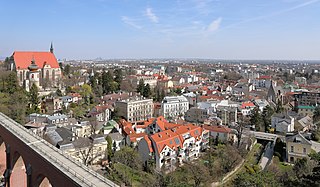
Deutsch: Blick von der Johannes-Ruhe über die niederösterreichische Bezirkshauptstadt Mödling in Richtung Nordost.
Links unten das 186 Meter lange und zwischen 1870 und 1873 errichtete Aquädukt der I. Wiener Hochquellenleitung über den Mödlingbach. Linke Seite Bildmitte die gotische St.-Othmar-Kirche, davor der Karner hl. Pantaleon, ein spätromanischer Rundbau mit Halbkreisapsis aus dem 12./13. Jahrhundert und rechte Seite Bildmitte die Spitalskirche, ein spätgotischer Sakralbau. |
| Datums | |
| Avots | Paša darbs |
| Autors | C.Stadler/Bwag |
| Atļauja: (Šī faila izmantošana citur) |
Deutsch: Hallo, du darfst mein Foto kostenlos nutzen, aber nenne mich bitte als Fotograf, beispielsweise „Foto: C.Stadler/Bwag“ oder © C.Stadler/Bwag; CC-BY-SA-4.0. Auf mehr Angaben bestehe ich nicht - im Gegensatz zu manch anderen, die die Vorgaben der unten angeführten Lizenzierung auf Punkt und Beistrich einfordern. English: Feel free to use my photos, but please mention me as the author like © C.Stadler/Bwag or © C.Stadler/Bwag; CC-BY-SA-4.0 (that's good enough) and if you want send me a message: bwag@gmx.net. |
| Camera location | | View this and other nearby images on: OpenStreetMap |
|---|
Licence
Es, šī darba autortiesību īpašnieks, publicēju to saskaņā ar šo licenci:
This file is licensed under the Creative Commons Attribution-Share Alike 4.0 International license.
- Jūs varat brīvi:
- koplietot – kopēt, izplatīt un pārraidīt darbu
- remiksēt – pielāgot darbu
- Saskaņā ar šādiem nosacījumiem:
- atsaucoties – Tev ir jānorāda autors, saite uz licenci un to, vai veiktas kādas izmaiņas. To var darīt jebkādā saprātīgā veidā, bet ne tādā, kas norādītu, ka licencētājs atbalsta tevi vai veidu, kā tu izmanto šo darbu.
- nemainot licenci – Ja tu miksē, pārveido vai izmanto materiālu, tev savs devums jāpublicē ar to pašu vai saderīgu licenci kā oriģināls.
| Annotations | This image is annotated: View the annotations at Commons |
Faila hronoloģija
Uzklikšķini uz datums/laiks kolonnā esošās saites, lai apskatītos, kā šis fails izskatījās tad.
| Datums/Laiks | Attēls | Izmēri | Dalībnieks | Komentārs | |
|---|---|---|---|---|---|
| tagadējais | 2017. gada 6. aprīlis, plkst. 13.45 | | 6 378 × 3 724 (20,98 MB) | Bwag | {{Information |Description= {{de|1=Blick von der Johannes-Ruhe über die niederösterreichischen Bezirkshauptstadt Mödling in Richtung Nordost.<br/>Links unten das 186 Meter lange und zwischen 1870 und 1873 errichtete Aquädukt der I... |
Faila lietojums
Šo failu izmanto šajā 1 lapā:
Globālais faila lietojums
Šīs Vikipēdijas izmanto šo failu:
- Izmantojums be-tarask.wikipedia.org
- Izmantojums da.wikipedia.org
- Izmantojums de.wikipedia.org
- Izmantojums de.wikivoyage.org
- Izmantojums en.wikipedia.org
- Izmantojums en.wikivoyage.org
- Izmantojums et.wikipedia.org
- Izmantojums eu.wikipedia.org
- Izmantojums fr.wikipedia.org
- Izmantojums hu.wikipedia.org
- Izmantojums hy.wikipedia.org
- Izmantojums id.wikipedia.org
- Izmantojums is.wikipedia.org
- Izmantojums it.wikipedia.org
- Izmantojums kk.wikipedia.org
- Izmantojums nl.wikipedia.org
- Izmantojums nn.wikipedia.org
- Izmantojums pl.wikipedia.org
- Izmantojums pt.wikipedia.org
- Izmantojums sr.wikipedia.org
- Izmantojums sv.wikipedia.org
- Izmantojums tr.wikipedia.org