
Attēls:Map Safavid persia.png

Šī priekšskata izmērs: 800 × 555 pikseļi. Citi izmēri: 320 × 222 pikseļi | 640 × 444 pikseļi | 1 033 × 717 pikseļi.
Sākotnējais fails (1 033 × 717 pikseļi, faila izmērs: 290 KB, MIME tips: image/png)
| Šis fails ir no Vikikrātuves. Tā apraksts no attēla lapas Vikikrātuvē ir parādīts zemāk. Vikikrātuve ir brīvi licencēta failu krātuve. Tu vari tai palīdzēt. |

|
This historical map image could be re-created using vector graphics as an SVG file. This has several advantages; see Commons:Media for cleanup for more information. If an SVG form of this image is available, please upload it and afterwards replace this template with
{{vector version available|new image name}}.
It is recommended to name the SVG file “Map Safavid persia.svg”—then the template Vector version available (or Vva) does not need the new image name parameter. |
|
Es, šī darba autortiesību īpašnieks, publicēju to saskaņā ar šo licenci: This file is licensed under the Creative Commons Attribution-Share Alike 2.5 Generic, 2.0 Generic and 1.0 Generic license.
|
|
|
|
Note : |

See also french version: Image:Map Safavid Persia-fr.png
Faila hronoloģija
Uzklikšķini uz datums/laiks kolonnā esošās saites, lai apskatītos, kā šis fails izskatījās tad.
| Datums/Laiks | Attēls | Izmēri | Dalībnieks | Komentārs | |
|---|---|---|---|---|---|
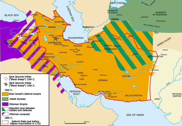
| tagadējais | 2011. gada 14. jūlijs, plkst. 18.27 | | 1 033 × 717 (290 KB) | Kentronhayastan | prvious edit didn't work.. |
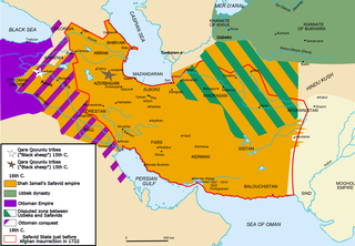
| 2011. gada 14. jūlijs, plkst. 18.25 |  | 1 033 × 717 (290 KB) | Kentronhayastan | fixed innacuracy about map: added ARRAN and SHIRVAN, very important regions in the Caucasus. | |
| 2006. gada 14. septembris, plkst. 00.55 |  | 1 033 × 717 (318 KB) | Fabienkhan | <div style="height:8px; border:1px solid #8898BF; -moz-border-radius-topleft:8px; -moz-border-radius-topright:8px; background:#C8D8FF; font-size:1px;"> </div> <div style="margin-bottom:1.5em; border:1px solid #8898BF; border-top:0; padding:5px; background |
Faila lietojums
Šo failu izmanto šajā 1 lapā:
Globālais faila lietojums
Šīs Vikipēdijas izmanto šo failu:
- Izmantojums af.wikipedia.org
- Izmantojums ar.wikipedia.org
- Izmantojums arz.wikipedia.org
- Izmantojums azb.wikipedia.org
- Izmantojums az.wikipedia.org
- Izmantojums bg.wikipedia.org
- Izmantojums bs.wikipedia.org
- Izmantojums ca.wikipedia.org
- Izmantojums cs.wikipedia.org
- Izmantojums de.wikipedia.org
- Izmantojums de.wikibooks.org
- Izmantojums de.wikiversity.org
- Izmantojums el.wikipedia.org
- Izmantojums en.wikipedia.org
- Ismail I
- Russo-Persian Wars
- History of Azerbaijan
- Portal:Azerbaijan
- Iraq
- Ottoman–Safavid relations
- Talk:Afghanistan/Archive 2
- Armenia
- Ottoman–Safavid War (1623–1639)
- Safavid Iran
- Talk:Babur/Archive 3
- Khalifeh Soltan
- User:GerardM/Battles including the Ottoman Empire
- User:Falcaorib
- Talk:Azerbaijan/Archive 8
- Talk:Armenia/Archive 9
- User:Wijbrand/sandbox
- Izmantojums eo.wikipedia.org
- Izmantojums es.wikipedia.org
- Izmantojums fa.wikipedia.org
- Izmantojums fr.wikipedia.org
Skatīt šī faila pilno globālo izmantojumu.