
Attēls:Map of Boston and Cambridge.png

Šī priekšskata izmērs: 800 × 600 pikseļi. Citi izmēri: 320 × 240 pikseļi | 640 × 480 pikseļi | 1 024 × 768 pikseļi | 1 280 × 960 pikseļi | 1 600 × 1 200 pikseļi.
Sākotnējais fails (1 600 × 1 200 pikseļi, faila izmērs: 1,98 MB, MIME tips: image/png)
| Šis fails ir no Vikikrātuves. Tā apraksts no attēla lapas Vikikrātuvē ir parādīts zemāk. Vikikrātuve ir brīvi licencēta failu krātuve. Tu vari tai palīdzēt. |
Kopsavilkums
| Apraksts |
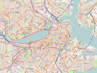
English: Map of the central area of Boston and Cambridge, exported from OpenStreetMap.
日本語: ボストン中心部及びケンブリッジの地図。オープン・ストリート・マップから作成。 |
||||||||||||
| Datums | |||||||||||||
| Avots | http://openstreetmap.org/ | ||||||||||||
| Autors | OpenStreetMap contributors | ||||||||||||
| Atļauja: (Šī faila izmantošana citur) |
|

|
This complex map image could be re-created using vector graphics as an SVG file. This has several advantages; see Commons:Media for cleanup for more information. If an SVG form of this image is available, please upload it and afterwards replace this template with
{{vector version available|new image name}}.Note: Existing vector data is available from osmwiki:SVG. It is recommended to name the SVG file “Map of Boston and Cambridge.svg”—then the template Vector version available (or Vva) does not need the new image name parameter. |
Maps of Cambridge
Licence
Šis fails tiek izplatīts saskaņā ar licences Creative Commons Atsauce-Līdzīgi Noteikumi 2.0 Vispārējiem noteikumiem.
- Jūs varat brīvi:
- koplietot – kopēt, izplatīt un pārraidīt darbu
- remiksēt – pielāgot darbu
- Saskaņā ar šādiem nosacījumiem:
- atsaucoties – Tev ir jānorāda autors, saite uz licenci un to, vai veiktas kādas izmaiņas. To var darīt jebkādā saprātīgā veidā, bet ne tādā, kas norādītu, ka licencētājs atbalsta tevi vai veidu, kā tu izmanto šo darbu.
- nemainot licenci – Ja tu miksē, pārveido vai izmanto materiālu, tev savs devums jāpublicē ar to pašu vai saderīgu licenci kā oriģināls.
Faila hronoloģija
Uzklikšķini uz datums/laiks kolonnā esošās saites, lai apskatītos, kā šis fails izskatījās tad.
| Datums/Laiks | Attēls | Izmēri | Dalībnieks | Komentārs | |
|---|---|---|---|---|---|
| tagadējais | 2009. gada 19. jūnijs, plkst. 03.01 | | 1 600 × 1 200 (1,98 MB) | Goyaz | {{Information |Description={{en|1=Map of the centeral area of Boston and Cambridge, exported from OpenStreetMap.}} {{ja|1=ボストン中心部及びケンブリッジの地図。[[w:ja:オープン・ストリート・マップ|オープン・スト� |
Faila lietojums
Šo failu izmanto šajā 1 lapā:
Globālais faila lietojums
Šīs Vikipēdijas izmanto šo failu:
- Izmantojums ar.wikipedia.org
- Izmantojums bg.wikipedia.org
- Izmantojums ceb.wikipedia.org
- Izmantojums cs.wikipedia.org
- Izmantojums en.wikipedia.org
- USS Constitution
- Battle of Bunker Hill
- Cocoanut Grove fire
- Wang Theatre
- Isabella Stewart Gardner Museum
- Ether Dome
- South End, Boston
- John Hancock Tower
- Back Bay, Boston
- TD Garden
- Faneuil Hall
- Beacon Hill, Boston
- Old South Meeting House
- Park Street Church
- Trinity Church (Boston)
- Bunker Hill Monument
- Museum of Fine Arts, Boston
- Quincy Market
- North–South Rail Link
- Old State House (Boston)
- John Joseph Moakley United States Courthouse
- Boston African American National Historic Site
- Tremont Street subway
- Harrison Gray Otis House
- Improv Asylum
- Peabody Museum of Archaeology and Ethnology
- Old City Hall (Boston)
- Landmark Center (Boston)
- Harvard Museum of Natural History
- Abbey Lounge
- Gibson House Museum
- The Club of Odd Volumes
- Boston Emergency Medical Services
- Nathan Appleton Residence
- Charles Street Jail
- Old Corner Bookstore
- Our Lady of Mount Carmel Church (East Boston, Massachusetts)
- Morse Auditorium
- Chester Harding House
- Vilna Shul
- William C. Nell House
- Charles Sumner House
- Copp's Hill Burying Ground
Skatīt šī faila pilno globālo izmantojumu.