
Attēls:Map of South Africa with West Rand highlighted (2011).svg

Size of this PNG preview of this SVG file: 684 × 599 pikseļi. Citi izmēri: 274 × 240 pikseļi | 548 × 480 pikseļi | 876 × 768 pikseļi | 1 168 × 1 024 pikseļi | 2 337 × 2 048 pikseļi | 809 × 709 pikseļi.
Sākotnējais fails (SVG fails, definētais izmērs 809 × 709 pikseļi, faila izmērs: 465 KB)
| Šis fails ir no Vikikrātuves. Tā apraksts no attēla lapas Vikikrātuvē ir parādīts zemāk. Vikikrātuve ir brīvi licencēta failu krātuve. Tu vari tai palīdzēt. |
.svg?uselang=lv)
Kopsavilkums
| Apraksts |
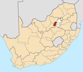
English: Map of district boundaries in South Africa, as they will be after the municipal elections of 18 May 2011, with the West Rand District Municipality highlighted in red within Gauteng in yellow. |
| Datums | |
| Avots | Paša darbs |
| Autors | Htonl |
Licence
Es, šī darba autortiesību īpašnieks, publicēju to saskaņā ar šīm licencēm:

|
Ir dota atļauja kopēt, izplatīt un/vai pārveidot šo dokumentu saskaņā ar GNU brīvās dokumentācijas licences, versijas 1.2 vai jebkuras vēlākas versijas, ko publiskojis Brīvās programmatūras fonds nosacījumiem; bez nemainīgajām sadaļā, priekšējā un aizmugurēja'vāka tekstiem. Licences kopija ir iekļauta sadaļā ar nosaukumu GNU brīvās dokumentācijas licence. |
This file is licensed under the Creative Commons Attribution-Share Alike 4.0 International, 3.0 Unported, 2.5 Generic, 2.0 Generic and 1.0 Generic license.
- Jūs varat brīvi:
- koplietot – kopēt, izplatīt un pārraidīt darbu
- remiksēt – pielāgot darbu
- Saskaņā ar šādiem nosacījumiem:
- atsaucoties – Tev ir jānorāda autors, saite uz licenci un to, vai veiktas kādas izmaiņas. To var darīt jebkādā saprātīgā veidā, bet ne tādā, kas norādītu, ka licencētājs atbalsta tevi vai veidu, kā tu izmanto šo darbu.
- nemainot licenci – Ja tu miksē, pārveido vai izmanto materiālu, tev savs devums jāpublicē ar to pašu vai saderīgu licenci kā oriģināls.
Jūs varat izvēlēties licenci pēc jūsu vēlmes.
Faila hronoloģija
Uzklikšķini uz datums/laiks kolonnā esošās saites, lai apskatītos, kā šis fails izskatījās tad.
| Datums/Laiks | Attēls | Izmēri | Dalībnieks | Komentārs | |
|---|---|---|---|---|---|
| tagadējais | 2011. gada 2. maijs, plkst. 23.17 | | 809 × 709 (465 KB) | Htonl | == Summary == {{Information |Description ={{en|1=Map of district boundaries in South Africa, as they will be after the municipal elections of 18 May 2011, with the w:West Rand District Municipality high |
Faila lietojums
Šo failu izmanto šajā 1 lapā:
Globālais faila lietojums
Šīs Vikipēdijas izmanto šo failu:
- Izmantojums af.wikipedia.org
- Krugersdorp
- Carletonville
- Randfontein
- Magaliesburg
- Westonaria
- Kagiso
- Fochville
- Muldersdrift
- Venterspos
- Modderfontein
- Bekkersdal
- Mohlakeng
- Khutsong
- Sjabloonbespreking:Suid-Afrikaanse distriksmunisipaliteit navbox
- Lindley, Gauteng
- Munsieville
- Rietvallei, Gauteng
- Blyvooruitzicht
- Oos-Driefontein
- Wes-Driefontein
- Oberholzer
- Elandsrand
- Welverdiend, Gauteng
- Azaadville
- Hekpoort
- Izmantojums bg.wikipedia.org
- Izmantojums en.wikipedia.org
- West Rand District Municipality
- Carletonville
- Krugersdorp
- Randfontein
- Westonaria
- Fochville
- Magaliesburg
- Lindley, Gauteng
- Rietvallei, Gauteng
- Driefontein, Gauteng
- Bekkersdal
- Kagiso
- Munsieville
- Mohlakeng
- Khutsong
- Boikarabelo
- Elandsrand
- West Driefontein
- East Driefontein
- Randfontein Local Municipality
- Westonaria Local Municipality
- Zuurbekom
- Template:West Rand District Municipality
- Merafong City Local Municipality
Skatīt šī faila pilno globālo izmantojumu.
.svg)
.svg)