
Attēls:Map of the Holy Roman Empire, 1789 en.png

Šī priekšskata izmērs: 736 × 600 pikseļi. Citi izmēri: 295 × 240 pikseļi | 589 × 480 pikseļi | 942 × 768 pikseļi | 1 256 × 1 024 pikseļi | 2 513 × 2 048 pikseļi | 2 650 × 2 160 pikseļi.
Sākotnējais fails (2 650 × 2 160 pikseļi, faila izmērs: 726 KB, MIME tips: image/png)
| Šis fails ir no Vikikrātuves. Tā apraksts no attēla lapas Vikikrātuvē ir parādīts zemāk. Vikikrātuve ir brīvi licencēta failu krātuve. Tu vari tai palīdzēt. |
Kopsavilkums
| Apraksts |
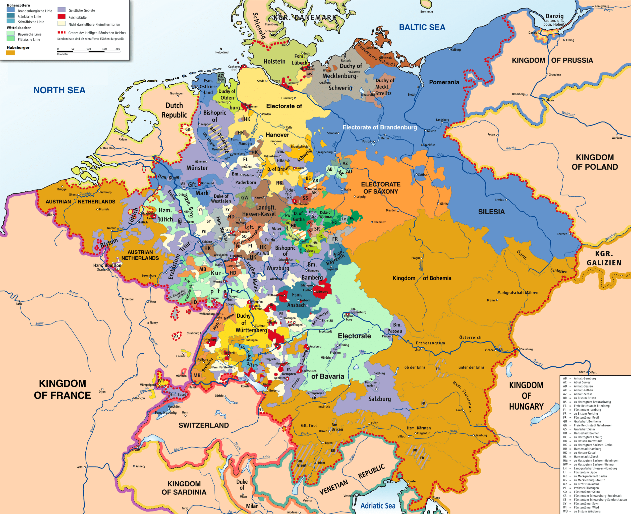
English: Map of the Holy Roman Empire, 1789. |
||
| Datums | |||
| Avots |
Own work based on: HRR 1789.png "translated (somewhat) from original German version" References:
|
||
| Izveidotājs |
Robert Alfers, ziegelbrenner |
||
| Georeferencing | If inappropriate please set warp_status = skip to hide. | ||
| Citas versijas |
 Ursprungskarte in Deutsch
|

Licence
This file is licensed under the Creative Commons Attribution-Share Alike 3.0 Unported, 2.5 Generic, 2.0 Generic and 1.0 Generic license.
- Jūs varat brīvi:
- koplietot – kopēt, izplatīt un pārraidīt darbu
- remiksēt – pielāgot darbu
- Saskaņā ar šādiem nosacījumiem:
- atsaucoties – Tev ir jānorāda autors, saite uz licenci un to, vai veiktas kādas izmaiņas. To var darīt jebkādā saprātīgā veidā, bet ne tādā, kas norādītu, ka licencētājs atbalsta tevi vai veidu, kā tu izmanto šo darbu.
- nemainot licenci – Ja tu miksē, pārveido vai izmanto materiālu, tev savs devums jāpublicē ar to pašu vai saderīgu licenci kā oriģināls.
Faila hronoloģija
Uzklikšķini uz datums/laiks kolonnā esošās saites, lai apskatītos, kā šis fails izskatījās tad.
| Datums/Laiks | Attēls | Izmēri | Dalībnieks | Komentārs | |
|---|---|---|---|---|---|
| tagadējais | 2018. gada 30. novembris, plkst. 17.47 | | 2 650 × 2 160 (726 KB) | FDRMRZUSA | Implemented map legend: inserted "Kilometers". |
| 2018. gada 30. novembris, plkst. 01.59 |  | 2 650 × 2 160 (810 KB) | FDRMRZUSA | Implemented map legend: "Habsburger". Reduced dimensions (size). | |
| 2013. gada 17. februāris, plkst. 19.17 |  | 2 650 × 2 160 (2,69 MB) | Opus33 | I've added a few more English place names, as follows: Wien > Vienna Muenchen > Munich Mailand > Milan Bruessel > Brussels Prag > Prague Antwerpen > Antwerp Triest > Trieste Warschau > Warsaw Gent > Ghent Erzbistum removed from Salzburg; should be Ar... | |
| 2010. gada 2. jūlijs, plkst. 20.08 |  | 2 650 × 2 160 (2,55 MB) | Ras67 | cropped | |
| 2008. gada 8. jūnijs, plkst. 07.09 |  | 2 659 × 2 170 (2,62 MB) | RobNS | {{Information |Description={{en|1=Map of the Holy Roman Empire, 1789, translated (somewhat) from original German version on Wikipedia Commons}} |Source=Own source, translated map from Image:HRR 1789.png, also on WC |Author=Robert Alfers, [[:de:Benutzer:kg |
Faila lietojums
Šo failu izmanto šajās 2 lapās:
Globālais faila lietojums
Šīs Vikipēdijas izmanto šo failu:
- Izmantojums als.wikipedia.org
- Izmantojums ar.wikipedia.org
- Izmantojums azb.wikipedia.org
- Izmantojums az.wikipedia.org
- Izmantojums be.wikipedia.org
- Izmantojums bg.wikipedia.org
- Izmantojums ca.wikipedia.org
- Izmantojums cs.wikipedia.org
- Izmantojums da.wikipedia.org
- Izmantojums de.wikipedia.org
- Izmantojums el.wikipedia.org
- Izmantojums en.wikipedia.org
- Battle of Rastatt (1796)
- Imperial immediacy
- Unification of Germany
- German mediatisation
- Kleinstaaterei
- Names of Germany
- Army of Sambre and Meuse
- Talk:Holy Roman Empire/Archive 1
- Austria–Germany relations
- Siege of Kehl (1796–1797)
- Wikipedia:Graphics Lab/Map workshop/Archive/Dec 2012
- Nationality of Wolfgang Amadeus Mozart
- Rhine campaign of 1796
- User:Dainomite/sandbox
- Dissolution of the Holy Roman Empire
- Rhine campaign of 1795
- Battle of Kehl (1796)
- Siege of Hüningen (1796–1797)
- Wikipedia:Village pump (technical)/Archive 144
- User:JMvanDijk/Sandbox 10
- Early clashes in the Rhine campaign of 1796
- User:Falcaorib
- User:Bunhouse768/sandbox
- User:Dronebogus/Don’t Balkanize Wikipedia
- Izmantojums es.wikipedia.org
Skatīt šī faila pilno globālo izmantojumu.