
Attēls:Mauretania et Numidia.jpg

Sākotnējais fails (3 509 × 1 383 pikseļi, faila izmērs: 494 KB, MIME tips: image/jpeg)
| Šis fails ir no Vikikrātuves. Tā apraksts no attēla lapas Vikikrātuvē ir parādīts zemāk. Vikikrātuve ir brīvi licencēta failu krātuve. Tu vari tai palīdzēt. |
Kopsavilkums
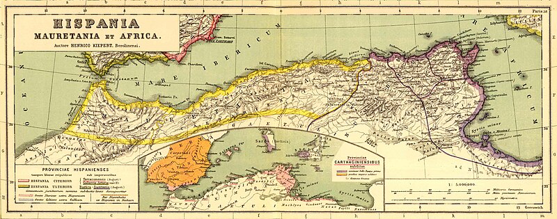
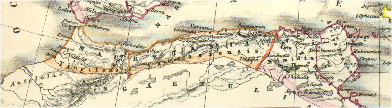
Bron: http://www.gottwein.de/latine/map/imp01_afr_nw.jpg
Autor: H.Kiepert, Atlas antiquus, Berlin (Reimer) o.J.
Licence
|
This work is in the public domain in its country of origin and other countries and areas where the copyright term is the author's life plus 70 years or fewer.
| |
| This file has been identified as being free of known restrictions under copyright law, including all related and neighboring rights. | |
Faila hronoloģija
Uzklikšķini uz datums/laiks kolonnā esošās saites, lai apskatītos, kā šis fails izskatījās tad.
| Datums/Laiks | Attēls | Izmēri | Dalībnieks | Komentārs | |
|---|---|---|---|---|---|
| tagadējais | 2011. gada 3. janvāris, plkst. 19.54 | 3 509 × 1 383 (494 KB) | Profburp | Meilleure définition. Extrait de la carte: Hispania, Mauretania et Africa. (with) Carthago. (with) Provinciae Carthaginiensibus subditae. Auctore Henrico Kiepert Berolinensi. Geographische Verlagshandlung Dietrich Reimer (Ernst Vohsen) Berlin, Wilhemlstr | |
| 2006. gada 13. maijs, plkst. 21.23 | 1 638 × 454 (175 KB) | Rodriguillo | {{nl|Uit: H.Kiepert, Atlas antiquus, Berlin (Reimer) o.J. Bron: http://www.gottwein.de/latine/map/imp01_afr_nw.jpg Kaart met de ''provinciae'' Mauretania Tingitana, Mauretania Caesariensis en Numidia.}} {{es|Mapa de las provincias roman |
Faila lietojums
Šo failu izmanto šajās 2 lapās:
Globālais faila lietojums
Šīs Vikipēdijas izmanto šo failu:
- Izmantojums am.wikipedia.org
- Izmantojums ar.wikipedia.org
- Izmantojums ary.wikipedia.org
- Izmantojums ast.wikipedia.org
- Izmantojums azb.wikipedia.org
- Izmantojums az.wikipedia.org
- Izmantojums be.wikipedia.org
- Izmantojums br.wikipedia.org
- Izmantojums ca.wikipedia.org
- Izmantojums ckb.wikipedia.org
- Izmantojums cs.wikipedia.org
- Izmantojums cy.wikipedia.org
- Izmantojums de.wikipedia.org
- Izmantojums en.wikipedia.org
- Izmantojums eo.wikipedia.org
- Izmantojums es.wikipedia.org
Skatīt šī faila pilno globālo izmantojumu.