
Attēls:Mazama bathymetry survey map.jpg
Augstāka izšķirtspēja nav pieejama.
Mazama_bathymetry_survey_map.jpg (600 × 345 pikseļi, faila izmērs: 61 KB, MIME tips: image/jpeg)
| Šis fails ir no Vikikrātuves. Tā apraksts no attēla lapas Vikikrātuvē ir parādīts zemāk. Vikikrātuve ir brīvi licencēta failu krātuve. Tu vari tai palīdzēt. |
| Apraksts |
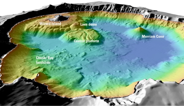
English: "Details of features beneath the surface of Crater Lake constructed using data from the 2000 bathymetry survey. Colors range from orange to blue with increasing water depth." |
| Avots | "Mount Mazama and Crater Lake: Growth and Destruction of a Cascade Volcano" |
| Autors | U.S. Geological Survey |
Licence
This image is in the public domain in the United States because it only contains materials that originally came from the United States Geological Survey, an agency of the United States Department of the Interior. For more information, see the official USGS copyright policy.
|
Original upload log
The original description page was here. All following user names refer to en.wikipedia.
- 2004-05-18 06:41 Mav 600×345× (62232 bytes) [[USGS]] image from [http://geopubs.wr.usgs.gov/fact-sheet/fs092-02/] <br><br>{{msg:PD}}
Faila hronoloģija
Uzklikšķini uz datums/laiks kolonnā esošās saites, lai apskatītos, kā šis fails izskatījās tad.
| Datums/Laiks | Attēls | Izmēri | Dalībnieks | Komentārs | |
|---|---|---|---|---|---|
| tagadējais | 2009. gada 13. jūlijs, plkst. 09.26 | | 600 × 345 (61 KB) | ZabMilenko | {{Information |Description={{en|en:USGS image from [http://geopubs.wr.usgs.gov/fact-sheet/fs092-02/] en:Category:Images of Oregon}} |Source=Transferred from [http://en.wikipedia.org en.wikipedia]; transferred to Commons by [[User:ZabMilenko |
Faila lietojums
Šo failu izmanto šajā 1 lapā:
Globālais faila lietojums
Šīs Vikipēdijas izmanto šo failu:
- Izmantojums bh.wikipedia.org
- Izmantojums el.wikipedia.org
- Izmantojums en.wikipedia.org
- Izmantojums eo.wikipedia.org
- Izmantojums es.wikipedia.org
- Izmantojums fa.wikipedia.org
- Izmantojums it.wikipedia.org
- Izmantojums ja.wikipedia.org
- Izmantojums ms.wikipedia.org
- Izmantojums simple.wikipedia.org
- Izmantojums sl.wikipedia.org
- Izmantojums ur.wikipedia.org
- Izmantojums vi.wikipedia.org
- Izmantojums www.wikidata.org
- Izmantojums zh.wikipedia.org