
Attēls:Metro Brussels.svg

Size of this PNG preview of this SVG file: 800 × 531 pikseļi. Citi izmēri: 320 × 212 pikseļi | 640 × 425 pikseļi | 1 024 × 680 pikseļi | 1 280 × 850 pikseļi | 2 560 × 1 699 pikseļi | 1 487 × 987 pikseļi.
Sākotnējais fails (SVG fails, definētais izmērs 1 487 × 987 pikseļi, faila izmērs: 1,01 MB)
| Šis fails ir no Vikikrātuves. Tā apraksts no attēla lapas Vikikrātuvē ir parādīts zemāk. Vikikrātuve ir brīvi licencēta failu krātuve. Tu vari tai palīdzēt. |
Kopsavilkums
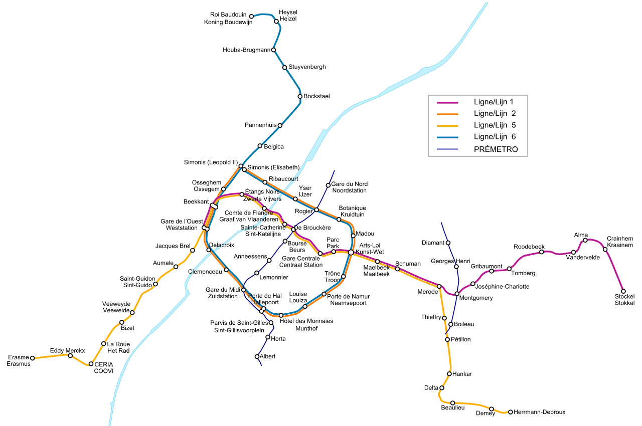
| Apraksts |
Deutsch: Karte des Brüsseler Metronetzes. Die sog. PREMETRO-Linien, die mit dünneren, blauen Linien dargestellt sind, sind unterirdische Straßenbahnstrecken, ähnlich der deutschen Stadtbahnnetze. Diese Strecken setzen sich an der Oberfläche über die hier gezeigten Abschnitte hinaus fort, was aber nicht abgebildet ist. Es existieren noch zwei weitere PREMETRO-Strecken, die allerdings nur jeweils eine Station haben, also habe ich aus Gründen der Übersichtlichkeit davon abgesehen, diese mit darzustellen. Stationen mit zwei Namen haben unterschiedliche Namen im Französischen bzw. Niederländischen. Stationen mit nur einem Namen besitzen keine Entsprechung in der jeweils anderen Sprache, bzw. beide Namen sind gleich.
English: Map of the Metro Network of the Belgian capital Brussels. The so called PREMETRO sections, which are shown by blue, thinner lines, are underground sections of the tram network and continue further above ground, which is not shown on the map. There are two more PREMETRO-sections which cover only one station each, so I decided not to display them for a clearer view. Stations with two names have different names in the French and Dutch language. The French name is always shown above the Dutch one. Stations with only one name don't have an expression in the other language or both names are the same.
Français : Plan du réseau de métros de Bruxelles, Belgique. Les sections appelées PRÉMÉTRO, en lignes bleues fines, sont les parties souterraines du réseau de tramways. Elle se poursuivent en surface mais ne sont pas représentées sur la carte. Il y a également deux autres sections de PRÉMÉTRO mais, pour des raisons de clarté, j'ai choisi de ne pas les représenter. Les stations avec deux noms ont un nom différent en français et en néerlandais. Le nom français est toujours situé au dessus du nom néerlandais. Les stations avec un seul nom n'ont pas d'équivalent dans l'autre langue ou bien les deux noms sont identiques.
Nederlands: Kaart van het Brusselse metronet, hoofdstad van België. De zogenaamde PREMETRO-secties, in dunne, blauwe lijnen, zijn ondergrondse tramlijnen die verder lopen boven de grond, wat niet weergegeven wordt op de kaart. Er zijn tevens twee andere secties van de PREMETRO, die elk een station bedienen en niet getekend zijn om de kaart duidelijk te houden. Bij de stations waar de Franse naam verschilt van de Nederlandse, werd het Frans bovenaan geplaatst. |
| Avots | Paša darbs |
| Autors | L.m.k |
| Citas versijas |
|


Licence
Es, šī darba autortiesību īpašnieks, publicēju to saskaņā ar šīm licencēm:

|
Ir dota atļauja kopēt, izplatīt un/vai pārveidot šo dokumentu saskaņā ar GNU brīvās dokumentācijas licences, versijas 1.2 vai jebkuras vēlākas versijas, ko publiskojis Brīvās programmatūras fonds nosacījumiem; bez nemainīgajām sadaļā, priekšējā un aizmugurēja'vāka tekstiem. Licences kopija ir iekļauta sadaļā ar nosaukumu GNU brīvās dokumentācijas licence. |
| Šis fails tiek izplatīts saskaņā ar licences Creative Commons Atsauce-Līdzīgi Noteikumi 3.0 Vispārējiem noteikumiem. | ||
| ||
| This licensing tag was added to this file as part of the GFDL licensing update. |
This file is licensed under the Creative Commons Attribution-Share Alike 2.5 Generic, 2.0 Generic and 1.0 Generic license.
- Jūs varat brīvi:
- koplietot – kopēt, izplatīt un pārraidīt darbu
- remiksēt – pielāgot darbu
- Saskaņā ar šādiem nosacījumiem:
- atsaucoties – Tev ir jānorāda autors, saite uz licenci un to, vai veiktas kādas izmaiņas. To var darīt jebkādā saprātīgā veidā, bet ne tādā, kas norādītu, ka licencētājs atbalsta tevi vai veidu, kā tu izmanto šo darbu.
- nemainot licenci – Ja tu miksē, pārveido vai izmanto materiālu, tev savs devums jāpublicē ar to pašu vai saderīgu licenci kā oriģināls.
Jūs varat izvēlēties licenci pēc jūsu vēlmes.
Faila hronoloģija
Uzklikšķini uz datums/laiks kolonnā esošās saites, lai apskatītos, kā šis fails izskatījās tad.
| Datums/Laiks | Attēls | Izmēri | Dalībnieks | Komentārs | |
|---|---|---|---|---|---|
| tagadējais | 2009. gada 3. maijs, plkst. 00.34 | | 1 487 × 987 (1,01 MB) | M0tty | Correction orthographe + taille police |
| 2009. gada 2. maijs, plkst. 01.34 |  | 1 457 × 992 (1,01 MB) | M0tty | corrections orthographiques | |
| 2009. gada 25. aprīlis, plkst. 00.59 |  | 1 457 × 992 (1,01 MB) | M0tty | Change on new metro | |
| 2007. gada 11. septembris, plkst. 11.51 |  | 1 457 × 992 (105 KB) | Poulpy | Gare Cantrale -> Gare Centrale | |
| 2006. gada 18. novembris, plkst. 03.39 |  | 1 457 × 992 (105 KB) | L.m.k | Added new line section | |
| 2005. gada 12. novembris, plkst. 03.50 |  | 1 457 × 992 (127 KB) | L.m.k | A station name wasn't aligned correctly. Now it is! | |
| 2005. gada 12. novembris, plkst. 03.41 |  | 1 457 × 992 (127 KB) | L.m.k | {{en|Map of the Metro Network of the Belgian capital Brussels. The so called PREMETRO sections, which are shown by blue, thinner lines, are underground sections of the tram network and countinue further above ground, which is not shown on the map. There a |
Faila lietojums
Šo failu izmanto šajā 1 lapā:
Globālais faila lietojums
Šīs Vikipēdijas izmanto šo failu:
- Izmantojums ar.wikipedia.org
- Izmantojums ba.wikipedia.org
- Izmantojums be-tarask.wikipedia.org
- Izmantojums bg.wikipedia.org
- Izmantojums bn.wikipedia.org
- Izmantojums ca.wikipedia.org
- Izmantojums cs.wikipedia.org
- Izmantojums cv.wikipedia.org
- Izmantojums da.wikipedia.org
- Izmantojums de.wikipedia.org
- Izmantojums el.wikipedia.org
- Izmantojums en.wikipedia.org
- Izmantojums eo.wikipedia.org
- Izmantojums es.wikipedia.org
- Izmantojums et.wikipedia.org
- Izmantojums eu.wikipedia.org
- Izmantojums fa.wikipedia.org
- Izmantojums fi.wikipedia.org
- Izmantojums fr.wikipedia.org
- Métro de Bruxelles
- Liste des stations du métro de Bruxelles
- Prémétro de Bruxelles
- Discussion utilisateur:TravauxSTIB
- Wikipédia:Atelier graphique/Images à améliorer/Archives/Avril 2009
- Wikipédia:Atelier graphique/Images à améliorer/Archives/Mai 2009
- Utilisateur:-Strogoff-/Archives 2009
- Utilisateur:Vascer/Brouillon2
- Izmantojums fr.wikivoyage.org
- Izmantojums fy.wikipedia.org
- Izmantojums hr.wikipedia.org
- Izmantojums hu.wikipedia.org
- Izmantojums hy.wikipedia.org
- Izmantojums it.wikipedia.org
- Izmantojums it.wikivoyage.org
- Izmantojums ka.wikipedia.org
- Izmantojums ko.wikipedia.org
- Izmantojums ku.wikipedia.org
- Izmantojums lb.wikipedia.org
Skatīt šī faila pilno globālo izmantojumu.