
Attēls:Mid-ocean ridge topography.gif
Augstāka izšķirtspēja nav pieejama.
Mid-ocean_ridge_topography.gif (240 × 180 pikseļi, faila izmērs: 1,06 MB, MIME tips: image/gif, looped, 70 kadri, 14 s)
| Šis fails ir no Vikikrātuves. Tā apraksts no attēla lapas Vikikrātuvē ir parādīts zemāk. Vikikrātuve ir brīvi licencēta failu krātuve. Tu vari tai palīdzēt. |
Kopsavilkums
| Apraksts |
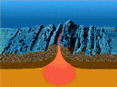
English: A close-up showing mid-ocean ridge topography with magma chamber below, which rises and new ocean plates spreads away from ridge. |
| Datums | |
| Avots | http://geomaps.wr.usgs.gov/parks/animate/index.html |
| Autors | USGS |
Licence
This image is in the public domain in the United States because it only contains materials that originally came from the United States Geological Survey, an agency of the United States Department of the Interior. For more information, see the official USGS copyright policy.
|
Faila hronoloģija
Uzklikšķini uz datums/laiks kolonnā esošās saites, lai apskatītos, kā šis fails izskatījās tad.
| Datums/Laiks | Attēls | Izmēri | Dalībnieks | Komentārs | |
|---|---|---|---|---|---|
| tagadējais | 2011. gada 19. februāris, plkst. 18.04 | | 240 × 180 (1,06 MB) | דקי | {{Information |Description ={{en|1=A close-up showing mid-ocean ridge topography with magma chamber below, which rises and new ocean plates spreads away from ridge.}} |Source =http://geomaps.wr.usgs.gov/parks/animate/index.html |Author |
Faila lietojums
Šo failu izmanto šajā 1 lapā:
Globālais faila lietojums
Šīs Vikipēdijas izmanto šo failu:
- Izmantojums an.wikipedia.org
- Izmantojums ar.wikipedia.org
- Izmantojums ast.wikipedia.org
- Izmantojums az.wikipedia.org
- Izmantojums bg.wikipedia.org
- Izmantojums ca.wikipedia.org
- Izmantojums de.wikipedia.org
- Izmantojums de.wiktionary.org
- Izmantojums en.wikipedia.org
- Izmantojums en.wikiquote.org
- Izmantojums es.wikipedia.org
- Izmantojums eu.wikipedia.org
- Izmantojums fi.wikipedia.org
- Izmantojums fr.wikipedia.org
- Izmantojums gl.wikipedia.org
- Izmantojums he.wikipedia.org
- Izmantojums hi.wikipedia.org
- Izmantojums hu.wikipedia.org
- Izmantojums it.wikipedia.org
- Izmantojums it.wikibooks.org
- Izmantojums it.wikiversity.org
- Izmantojums ja.wikipedia.org
- Izmantojums ja.wikibooks.org
- Izmantojums ko.wikipedia.org
- Izmantojums kw.wikipedia.org
- Izmantojums mk.wikipedia.org
- Izmantojums ml.wikipedia.org
Skatīt šī faila pilno globālo izmantojumu.