
Attēls:Montjuïc circuit.svg

Size of this PNG preview of this SVG file: 800 × 531 pikseļi. Citi izmēri: 320 × 212 pikseļi | 640 × 425 pikseļi | 1 024 × 680 pikseļi | 1 280 × 850 pikseļi | 2 560 × 1 700 pikseļi | 1 512 × 1 004 pikseļi.
Sākotnējais fails (SVG fails, definētais izmērs 1 512 × 1 004 pikseļi, faila izmērs: 318 KB)
| Šis fails ir no Vikikrātuves. Tā apraksts no attēla lapas Vikikrātuvē ir parādīts zemāk. Vikikrātuve ir brīvi licencēta failu krātuve. Tu vari tai palīdzēt. |
Kopsavilkums
| Apraksts |
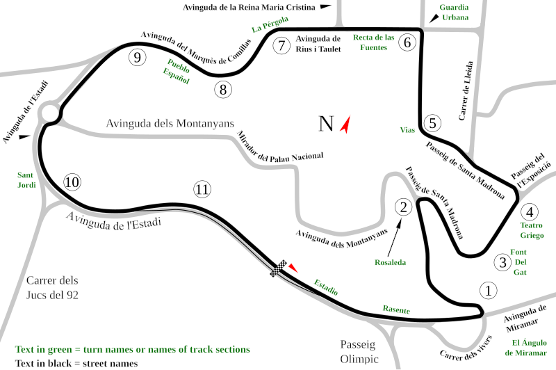
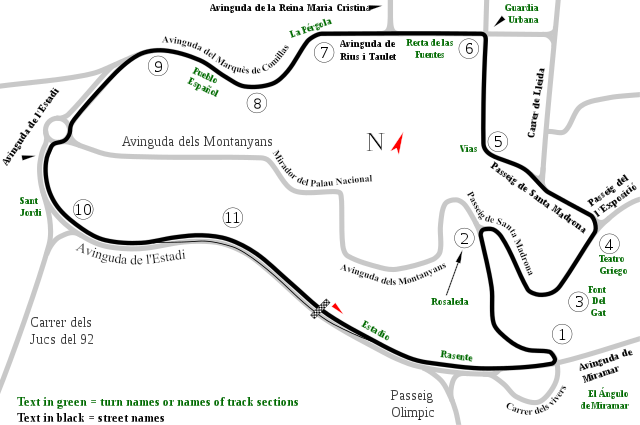
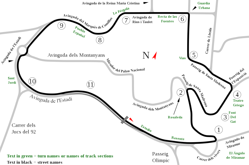
English: Track map of Montjuïc circuit. Gray lines are streets. Green text are either turn names or track section names. Black text (with out the circle) are street names. |
| Datums | |
| Avots | Paša darbs |
| Autors | Will Pittenger |
| Citas versijas |
|

| Camera location | | View this and other nearby images on: OpenStreetMap |
|---|
Licence
| I, the copyright holder of this work, release this work into the public domain. This applies worldwide. In some countries this may not be legally possible; if so: I grant anyone the right to use this work for any purpose, without any conditions, unless such conditions are required by law. |
Faila hronoloģija
Uzklikšķini uz datums/laiks kolonnā esošās saites, lai apskatītos, kā šis fails izskatījās tad.
| Datums/Laiks | Attēls | Izmēri | Dalībnieks | Komentārs | |
|---|---|---|---|---|---|
| tagadējais | 2008. gada 19. jūlijs, plkst. 15.55 | | 1 512 × 1 004 (318 KB) | Will Pittenger | Once again, please use the previous version if you need to edit the file. |
| 2008. gada 19. jūlijs, plkst. 15.54 |  | 1 512 × 1 004 (128 KB) | Will Pittenger | Corrected typos. The text objects that were on paths are back on paths. | |
| 2008. gada 19. jūlijs, plkst. 15.20 |  | 1 512 × 1 004 (318 KB) | Will Pittenger | Mediawiki/RSVG has problems with text on paths. It tends to hide such text objects. This version gets around that bug by converting such objects to paths. If you need to edit the file, please use the previous version. | |
| 2008. gada 19. jūlijs, plkst. 15.17 |  | 1 512 × 1 004 (128 KB) | Will Pittenger | New version has keywords added. | |
| 2008. gada 19. jūlijs, plkst. 14.58 |  | 1 512 × 1 004 (127 KB) | Will Pittenger | This version fixes the document size. | |
| 2008. gada 19. jūlijs, plkst. 14.54 |  | 744 × 1 052 (126 KB) | Will Pittenger | {{Information |Description={{en|1=Track map of w:Montjuïc circuit. Gray lines are streets. Green text are either turn names or track section names. Black text (with out the circle) are street names.}} |Source=Own work by uploader |Author=[[User:W |
Faila lietojums
Šo failu izmanto šajās 2 lapās:
Globālais faila lietojums
Šīs Vikipēdijas izmanto šo failu:
- Izmantojums af.wikipedia.org
- Izmantojums ar.wikipedia.org
- Izmantojums ast.wikipedia.org
- Izmantojums bg.wikipedia.org
- Izmantojums bn.wikipedia.org
- Izmantojums br.wikipedia.org
- Izmantojums ca.wikipedia.org
- Circuit de Montjuïc
- 24 Hores de Montjuïc
- Gran Premi d'Espanya de motociclisme de 1964
- Gran Premi d'Espanya de motociclisme de 1965
- Gran Premi d'Espanya de motociclisme de 1966
- Gran Premi d'Espanya de motociclisme de 1968
- Gran Premi d'Espanya de motociclisme de 1974
- Gran Premi d'Espanya de motociclisme de 1961
- Gran Premi d'Espanya de motociclisme de 1962
- Gran Premi d'Espanya de motociclisme de 1963
- Gran Premi d'Espanya de motociclisme de 1967
- Gran Premi d'Espanya de motociclisme de 1970
- 24 Hores de Montjuïc 1961
- 24 Hores de Montjuïc 1962
- 24 Hores de Montjuïc 1965
- 24 Hores de Montjuïc 1968
- 24 Hores de Montjuïc 1973
- 24 Hores de Montjuïc 1977
- 24 Hores de Montjuïc 1979
- 24 Hores de Montjuïc 1981
- 24 Hores de Montjuïc 1982
- 24 Hores de Montjuïc 1984
- 24 Hores de Montjuïc 1985
- Izmantojums cs.wikipedia.org
- Izmantojums de.wikipedia.org
- Izmantojums en.wikipedia.org
Skatīt šī faila pilno globālo izmantojumu.