
Attēls:Official New York City Subway Map 2013 vc.jpg

Šī priekšskata izmērs: 492 × 599 pikseļi. Citi izmēri: 197 × 240 pikseļi | 394 × 480 pikseļi | 631 × 768 pikseļi | 841 × 1 024 pikseļi | 1 419 × 1 728 pikseļi.
Sākotnējais fails (1 419 × 1 728 pikseļi, faila izmērs: 1,03 MB, MIME tips: image/jpeg)
| Šis fails ir no Vikikrātuves. Tā apraksts no attēla lapas Vikikrātuvē ir parādīts zemāk. Vikikrātuve ir brīvi licencēta failu krātuve. Tu vari tai palīdzēt. |
Kopsavilkums
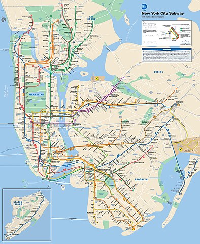
| Apraksts | This is the official map of the New York City Subway as of June 2013 and produced by the Metropolitan Transportation Authority of the State of New York. |
| Datums | |
| Avots |
Official New York City Subway Map
|
| Autors | Metropolitan Transportation Authority of the State of New York |
Licence
Šis fails tiek izplatīts saskaņā ar licences Creative Commons Atsauce 2.0 Vispārējiem noteikumiem.
- Jūs varat brīvi:
- koplietot – kopēt, izplatīt un pārraidīt darbu
- remiksēt – pielāgot darbu
- Saskaņā ar šādiem nosacījumiem:
- atsaucoties – Tev ir jānorāda autors, saite uz licenci un to, vai veiktas kādas izmaiņas. To var darīt jebkādā saprātīgā veidā, bet ne tādā, kas norādītu, ka licencētājs atbalsta tevi vai veidu, kā tu izmanto šo darbu.

|
This work includes material that may be protected as a trademark in some jurisdictions. If you want to use it, you have to ensure that you have the legal right to do so and that you do not infringe any trademark rights. See our general disclaimer. This tag does not indicate the copyright status of the attached work. A normal copyright tag is still required. See Commons:Licensing. |
| This image, originally posted to Flickr, was reviewed on 11 June 2013 by the administrator or reviewer File Upload Bot (Magnus Manske), who confirmed that it was available on Flickr under the stated license on that date. |
Faila hronoloģija
Uzklikšķini uz datums/laiks kolonnā esošās saites, lai apskatītos, kā šis fails izskatījās tad.
| Datums/Laiks | Attēls | Izmēri | Dalībnieks | Komentārs | |
|---|---|---|---|---|---|
| tagadējais | 2020. gada 27. novembris, plkst. 23.56 | | 1 419 × 1 728 (1,03 MB) | Pi.1415926535 | Reverted to version as of 18:22, 11 June 2013 (UTC) per Commons:Deletion requests/File:Official New York City Subway Map vc.jpg |
| 2019. gada 6. novembris, plkst. 05.48 |  | 2 700 × 3 314 (5,34 MB) | Ɱ | One station opened (WTC Cortlandt) | |
| 2019. gada 28. oktobris, plkst. 17.04 |  | 6 003 × 7 258 (9,71 MB) | Ɱ | Did you not read what I wrote? This is not a significant enough derivative to be in copyright. | |
| 2019. gada 28. oktobris, plkst. 10.15 |  | 1 419 × 1 728 (1,03 MB) | Vcohen | Reverted to version as of 21:16, 4 January 2017 (UTC) the license is for the 2013 version | |
| 2019. gada 28. oktobris, plkst. 07.33 |  | 6 003 × 7 258 (9,71 MB) | Ɱ | somehow lost resolution | |
| 2019. gada 28. oktobris, plkst. 07.30 |  | 6 003 × 7 258 (9,71 MB) | Ɱ | Not significant enough expressive changes to qualify as a derivative work of the 2013 copy, only minor alterations. | |
| 2017. gada 5. janvāris, plkst. 00.16 |  | 1 419 × 1 728 (1,03 MB) | Vcohen | the new version does not match the source and license | |
| 2017. gada 2. janvāris, plkst. 08.10 |  | 2 001 × 2 419 (1,32 MB) | Cbuccella | Official MTA subway map as of 2017.01.01. Includes Hudson Yards station and Q Line extension. | |
| 2013. gada 11. jūnijs, plkst. 21.22 |  | 1 419 × 1 728 (1,03 MB) | File Upload Bot (Magnus Manske) | Transferred from Flickr by User:vcohen using flickr2commons |
Faila lietojums
Šo failu neizmanto nevienā lapā.
Globālais faila lietojums
Šīs Vikipēdijas izmanto šo failu:
- Izmantojums az.wikipedia.org
- Izmantojums be.wikipedia.org
- Izmantojums de.wikipedia.org
- Izmantojums en.wikipedia.org
- Izmantojums he.wikipedia.org
- Izmantojums hr.wikipedia.org
- Izmantojums id.wikipedia.org
- Izmantojums it.wikipedia.org
- Izmantojums ja.wikipedia.org
- Izmantojums ko.wikipedia.org
- Izmantojums ru.wikipedia.org
- Izmantojums tl.wikipedia.org
- Izmantojums tr.wikipedia.org
- Izmantojums uk.wikipedia.org
- Izmantojums www.wikidata.org
- Izmantojums zh.wikipedia.org