
Attēls:Partitions of Moldavia.jpg

Šī priekšskata izmērs: 215 × 597 pikseļi. Citi izmēri: 86 × 240 pikseļi | 172 × 480 pikseļi | 665 × 1 848 pikseļi.
Sākotnējais fails (665 × 1 848 pikseļi, faila izmērs: 635 KB, MIME tips: image/jpeg)
| Šis fails ir no Vikikrātuves. Tā apraksts no attēla lapas Vikikrātuvē ir parādīts zemāk. Vikikrātuve ir brīvi licencēta failu krātuve. Tu vari tai palīdzēt. |

|
This historical map image could be re-created using vector graphics as an SVG file. This has several advantages; see Commons:Media for cleanup for more information. If an SVG form of this image is available, please upload it and afterwards replace this template with
{{vector version available|new image name}}.
It is recommended to name the SVG file “Partitions of Moldavia.svg”—then the template Vector version available (or Vva) does not need the new image name parameter. |


Kopsavilkums
| Apraksts |
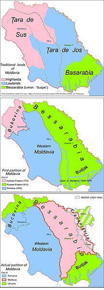
English: Historic map: partitions of Moldavia |
| Datums | |
| Avots | Paša darbs |
| Autors | Aoleuvaidenoi |
Licence
| I, the copyright holder of this work, release this work into the public domain. This applies worldwide. In some countries this may not be legally possible; if so: I grant anyone the right to use this work for any purpose, without any conditions, unless such conditions are required by law. |
Faila hronoloģija
Uzklikšķini uz datums/laiks kolonnā esošās saites, lai apskatītos, kā šis fails izskatījās tad.
| Datums/Laiks | Attēls | Izmēri | Dalībnieks | Komentārs | |
|---|---|---|---|---|---|
| tagadējais | 2019. gada 9. aprīlis, plkst. 12.53 | 665 × 1 848 (635 KB) | Julieta39 | Correct Iași (Яссы) County since the same map. | |
| 2018. gada 5. oktobris, plkst. 14.06 | 665 × 1 848 (634 KB) | Julieta39 | Correct Highlands & Lowlands since Demetrius Cantemir's map restituted by Vladimir Mironescu: see [https://commons.wikimedia.org/wiki/File:Moldova_Stefan_cel_Mare.png] | ||
| 2015. gada 8. maijs, plkst. 21.35 | 665 × 1 848 (605 KB) | Spiridon Ion Cepleanu | Colours | ||
| 2010. gada 30. decembris, plkst. 20.40 | 665 × 1 848 (582 KB) | Aoleuvaidenoi | {{Information |Description={{en|1=Historic map: partitions of Moldavia}} |Source={{own}} |Author=Aoleuvaidenoi |Date=December 30, 2010 |Permission= |other_versions= }} Category:Maps of Moldova |
Faila lietojums
Šo failu izmanto šajās 2 lapās:
Globālais faila lietojums
Šīs Vikipēdijas izmanto šo failu:
- Izmantojums ar.wikipedia.org
- Izmantojums azb.wikipedia.org
- Izmantojums ba.wikipedia.org
- Izmantojums br.wikipedia.org
- Izmantojums bs.wikipedia.org
- Izmantojums de.wikipedia.org
- Izmantojums el.wikipedia.org
- Izmantojums en.wikipedia.org
- Izmantojums es.wikipedia.org
- Izmantojums et.wikipedia.org
- Izmantojums fr.wikipedia.org
- Izmantojums hu.wikipedia.org
- Izmantojums io.wikipedia.org
- Izmantojums it.wikipedia.org
- Izmantojums lt.wikipedia.org
- Izmantojums mk.wikipedia.org
- Izmantojums ms.wikipedia.org
- Izmantojums mt.wikipedia.org
- Izmantojums pl.wikipedia.org
- Izmantojums pnb.wikipedia.org
- Izmantojums pt.wikipedia.org
- Izmantojums rm.wikipedia.org
- Izmantojums ro.wikipedia.org
Skatīt šī faila pilno globālo izmantojumu.